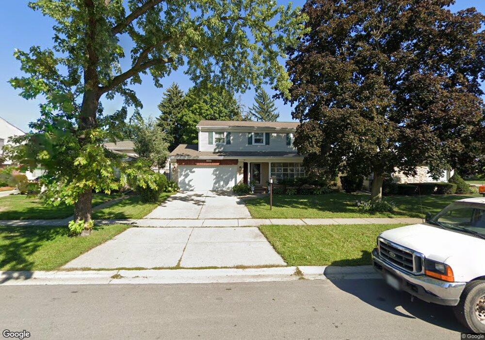
1443 Webster Ln Des Plaines, IL 60018
Estimated Value: $489,623 - $574,000
4
Beds
3
Baths
2,080
Sq Ft
$256/Sq Ft
Est. Value
About This Home
This home is located at 1443 Webster Ln, Des Plaines, IL 60018 and is currently estimated at $531,656, approximately $255 per square foot. 1443 Webster Ln is a home located in Cook County with nearby schools including Forest Elementary School, Algonquin Middle School, and Maine West High School.
Ownership History
Date
Name
Owned For
Owner Type
Purchase Details
Closed on
Aug 12, 1997
Sold by
Cassidy Robert J and Cassidy Phyllis M
Bought by
Nienart Adam Z and Nienart Danuta
Current Estimated Value
Home Financials for this Owner
Home Financials are based on the most recent Mortgage that was taken out on this home.
Original Mortgage
$130,000
Outstanding Balance
$17,116
Interest Rate
7.55%
Estimated Equity
$514,540
Create a Home Valuation Report for This Property
The Home Valuation Report is an in-depth analysis detailing your home's value as well as a comparison with similar homes in the area
Home Values in the Area
Average Home Value in this Area
Purchase History
| Date | Buyer | Sale Price | Title Company |
|---|---|---|---|
| Nienart Adam Z | $136,666 | -- |
Source: Public Records
Mortgage History
| Date | Status | Borrower | Loan Amount |
|---|---|---|---|
| Open | Nienart Adam Z | $130,000 |
Source: Public Records
Tax History
| Year | Tax Paid | Tax Assessment Tax Assessment Total Assessment is a certain percentage of the fair market value that is determined by local assessors to be the total taxable value of land and additions on the property. | Land | Improvement |
|---|---|---|---|---|
| 2025 | $6,610 | $47,000 | $8,492 | $38,508 |
| 2024 | $6,610 | $31,039 | $7,077 | $23,962 |
| 2023 | $7,165 | $34,000 | $7,077 | $26,923 |
| 2022 | $7,165 | $34,000 | $7,077 | $26,923 |
| 2021 | $5,539 | $24,013 | $4,600 | $19,413 |
| 2020 | $5,569 | $24,013 | $4,600 | $19,413 |
| 2019 | $5,600 | $26,981 | $4,600 | $22,381 |
| 2018 | $6,633 | $28,363 | $4,069 | $24,294 |
| 2017 | $6,548 | $28,363 | $4,069 | $24,294 |
| 2016 | $7,837 | $30,701 | $4,069 | $26,632 |
| 2015 | $6,326 | $23,548 | $3,538 | $20,010 |
| 2014 | $6,750 | $25,378 | $3,538 | $21,840 |
| 2013 | $7,109 | $27,264 | $3,538 | $23,726 |
Source: Public Records
Map
Nearby Homes
- 1394 Carol Ln
- 1080 Bogart St
- 815 E Oakton St Unit 311
- 1162 W Grant Dr
- 664 E Oakton St
- 674 E Algonquin Rd
- 1673 Spruce Ave
- 1205 S Wolf Rd
- 505 Forest Ave
- 980 W Grant Dr
- 1122 Alfini Dr
- 1696 S Elm St
- 1596 Oxford Rd
- 1689 S Elm St
- 1645 Illinois St
- 1445 Everett Ave
- 1380 Oakwood Ave Unit 306
- 886 E Thacker St
- 900 Center St Unit 3A
- 905 Center St Unit B208
- 1435 Webster Ln
- 1451 Webster Ln
- 1425 Webster Ln
- 1442 S 2nd Ave
- 1450 S 2nd Ave
- 1434 S 2nd Ave
- 1419 Webster Ln
- 1426 S 2nd Ave
- 1469 Webster Ln
- 1442 Webster Ln
- 1434 Webster Ln
- 1450 Webster Ln
- 1418 S 2nd Ave
- 1426 Webster Ln
- 951 E Forest Ave
- 971 Wicke Ave
- 1458 Webster Ln
- 1418 Webster Ln
- 1477 Webster Ln
- 1466 Webster Ln
Your Personal Tour Guide
Ask me questions while you tour the home.