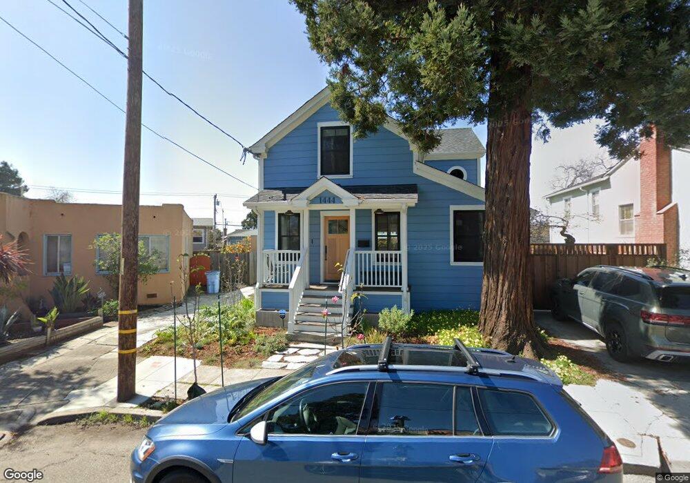
1444 Neilson St Berkeley, CA 94702
West Berkeley NeighborhoodEstimated Value: $1,452,000 - $1,756,000
2
Beds
1
Bath
1,230
Sq Ft
$1,286/Sq Ft
Est. Value
About This Home
This home is located at 1444 Neilson St, Berkeley, CA 94702 and is currently estimated at $1,582,000, approximately $1,286 per square foot. 1444 Neilson St is a home located in Alameda County with nearby schools including Ruth Acty Elementary, Rosa Parks Elementary School, and Berkeley Arts Magnet at Whittier School.
Ownership History
Date
Name
Owned For
Owner Type
Purchase Details
Closed on
May 21, 2015
Sold by
Bautista Leo F and The Mielke Investment Trust
Bought by
Evans Steven and Evans Tierra
Current Estimated Value
Purchase Details
Closed on
Jan 3, 2013
Sold by
Mielke Robert B
Bought by
Bautista Leo F and Mielke Investment Trust
Purchase Details
Closed on
Jun 13, 2007
Sold by
Mielke Robert B
Bought by
Mielke Robert B and The Robert B Mielke 2007 Trust
Create a Home Valuation Report for This Property
The Home Valuation Report is an in-depth analysis detailing your home's value as well as a comparison with similar homes in the area
Home Values in the Area
Average Home Value in this Area
Purchase History
| Date | Buyer | Sale Price | Title Company |
|---|---|---|---|
| Evans Steven | $895,000 | Old Republic Title Company | |
| Bautista Leo F | -- | None Available | |
| Mielke Robert B | -- | None Available | |
| Mielke Robert B | -- | None Available |
Source: Public Records
Tax History
| Year | Tax Paid | Tax Assessment Tax Assessment Total Assessment is a certain percentage of the fair market value that is determined by local assessors to be the total taxable value of land and additions on the property. | Land | Improvement |
|---|---|---|---|---|
| 2025 | $20,647 | $1,354,692 | $322,685 | $1,039,007 |
| 2024 | $20,647 | $1,327,998 | $316,360 | $1,018,638 |
| 2023 | $20,180 | $1,308,826 | $310,157 | $998,669 |
| 2022 | $19,836 | $1,276,163 | $304,076 | $979,087 |
| 2021 | $21,026 | $1,251,008 | $298,115 | $959,893 |
| 2020 | $15,976 | $1,098,929 | $295,060 | $803,869 |
| 2019 | $15,768 | $1,077,387 | $289,276 | $788,111 |
| 2018 | $13,470 | $945,351 | $283,605 | $661,746 |
| 2017 | $13,005 | $926,817 | $278,045 | $648,772 |
| 2016 | $12,671 | $908,648 | $272,594 | $636,054 |
| 2015 | $2,059 | $39,166 | $26,927 | $12,239 |
| 2014 | $1,998 | $38,399 | $26,400 | $11,999 |
Source: Public Records
Map
Nearby Homes
- 1339 Kains Ave
- 1631 Belvedere Ave
- 1368 Rose St
- 1234 Stannage Ave
- 1207 Cornell Ave
- 1322 Virginia St
- 1213 San Pablo Ave
- 1728 Curtis St
- 1127 Key Route Blvd
- 1120 Curtis St
- 1114 Talbot Ave
- 1564 Sacramento St
- 1509 Francis St
- 995 Virginia St
- 921 Jones St
- 1128 Delaware St
- 1261 Hearst Ave
- 1036 Ramona Ave
- 1050 Kains Ave Unit B1(3)
- 1919 Curtis St
- 1440 Neilson St
- 1446 Neilson St
- 1438 Neilson St
- 1455 Curtis St
- 1448 Neilson St
- 1445 Curtis St
- 1449 Curtis St
- 1459 Curtis St
- 1441 Curtis St
- 1436 Neilson St
- 1445 Neilson St
- 1435 Curtis St
- 1461 Curtis St
- 1229 Hopkins St
- 1434 Neilson St
- 1233 Hopkins St
- 1227 Hopkins St
- 1433 Curtis St
- 1482 Northside Ave
- 1463 Curtis St
Your Personal Tour Guide
Ask me questions while you tour the home.