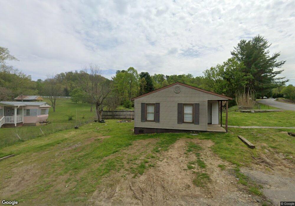
1447 Mae Collins Rd Morristown, TN 37813
Estimated Value: $114,000 - $137,000
--
Bed
1
Bath
804
Sq Ft
$156/Sq Ft
Est. Value
About This Home
This home is located at 1447 Mae Collins Rd, Morristown, TN 37813 and is currently estimated at $125,500, approximately $156 per square foot. 1447 Mae Collins Rd is a home located in Hamblen County with nearby schools including Witt Elementary School, Lincoln Heights Middle School, and Morristown West High School.
Ownership History
Date
Name
Owned For
Owner Type
Purchase Details
Closed on
May 13, 2022
Sold by
Earls Charles D and Bell Cindy M
Bought by
Jpp Holdings Llc
Current Estimated Value
Purchase Details
Closed on
Sep 7, 2004
Bought by
Secretary Of H U D Att Sandy Pavlak
Purchase Details
Closed on
Jul 12, 2004
Bought by
Tennessee H D Agency %First Horizon Home Loan
Purchase Details
Closed on
Sep 17, 1999
Bought by
Mitchell Jeffrey C
Purchase Details
Closed on
Jul 14, 1966
Bought by
Dover Harold and Dover Elaine
Create a Home Valuation Report for This Property
The Home Valuation Report is an in-depth analysis detailing your home's value as well as a comparison with similar homes in the area
Home Values in the Area
Average Home Value in this Area
Purchase History
| Date | Buyer | Sale Price | Title Company |
|---|---|---|---|
| Jpp Holdings Llc | -- | Lakeway Title Services | |
| Secretary Of H U D Att Sandy Pavlak | -- | -- | |
| Tennessee H D Agency %First Horizon Home Loan | $57,500 | -- | |
| Mitchell Jeffrey C | $57,500 | -- | |
| Dover Harold | -- | -- |
Source: Public Records
Tax History Compared to Growth
Tax History
| Year | Tax Paid | Tax Assessment Tax Assessment Total Assessment is a certain percentage of the fair market value that is determined by local assessors to be the total taxable value of land and additions on the property. | Land | Improvement |
|---|---|---|---|---|
| 2024 | $195 | $9,900 | $1,125 | $8,775 |
| 2023 | $195 | $9,900 | $0 | $0 |
| 2022 | $195 | $9,900 | $1,125 | $8,775 |
| 2021 | $195 | $9,900 | $1,125 | $8,775 |
| 2020 | $195 | $9,900 | $1,125 | $8,775 |
| 2019 | $194 | $9,100 | $825 | $8,275 |
| 2018 | $194 | $9,100 | $825 | $8,275 |
| 2017 | $194 | $9,100 | $825 | $8,275 |
| 2016 | $181 | $9,100 | $825 | $8,275 |
| 2015 | $168 | $9,100 | $825 | $8,275 |
| 2014 | -- | $9,100 | $825 | $8,275 |
| 2013 | -- | $9,375 | $0 | $0 |
Source: Public Records
Map
Nearby Homes
- 1418 Mae Collins Rd
- 1160 Statem Gap Rd
- 453 Statem Gap Rd
- 2018 Southwood Cir
- 1049 Greenway Dr
- Darwin Plan at Southwood
- Robie Plan at Southwood
- Elston Plan at Southwood
- Belhaven Plan at Southwood
- Penwell Plan at Southwood
- Cali Plan at Southwood
- 203 Lincoln Ave
- 305-365 Barkley Landing Dr
- 3520 Sublett Rd
- 440 S Fairmont Ave
- 1500 S Davy Crockett Pkwy
- 837 Pauline Ave
- 731 Lennie Ave
- 1621 S Cumberland St
- 323 Pauline Ave
- 2307 Sulphur Springs Rd
- 1441 Mae Collins Rd
- 1442 Mae Collins Rd
- 2343 Sulphur Springs Rd
- 1428 Pine Brooke Rd
- 2368 Sulphur Springs Rd
- 2385 Sulphur Springs Rd
- 2366 Sulphur Springs Rd
- 2264 Junction Ln
- 1418 Pine Brooke Rd
- 2151 Sulphur Springs Rd
- 1480 Pine Brooke Rd
- 2010 Sulphur Springs Rd
- 1400 Pine Brooke Rd
- 1984 Claude Collins Rd
- 1395 Mae Collins Rd
- 2145 Sulphur Springs Rd
- 2528 Sulphur Springs Rd
- 2316 Junction Ln
- 1441 Pine Brooke Rd