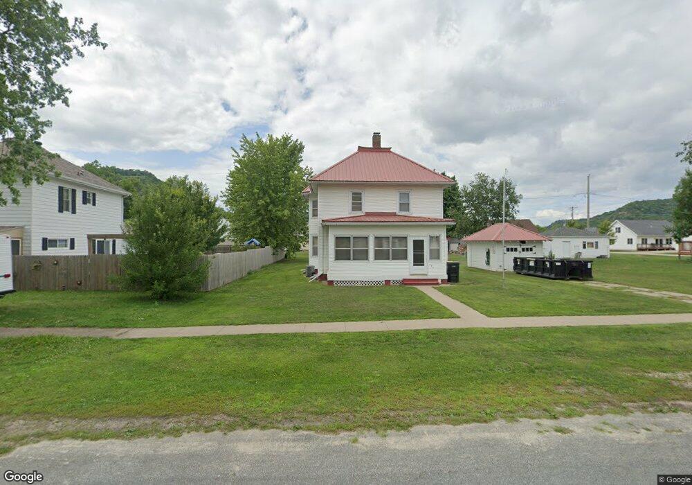
145 2nd St NE New Albin, IA 52160
Estimated Value: $157,000 - $175,000
3
Beds
3
Baths
1,628
Sq Ft
$101/Sq Ft
Est. Value
About This Home
This home is located at 145 2nd St NE, New Albin, IA 52160 and is currently estimated at $164,161, approximately $100 per square foot. 145 2nd St NE is a home with nearby schools including New Albin Elementary School, Lansing Middle School, and Kee High School.
Ownership History
Date
Name
Owned For
Owner Type
Purchase Details
Closed on
Aug 18, 2023
Sold by
Sommermeyer Jon D and Sommermeyer Donald Robert
Bought by
Peterson Dylan J and Hobson Brooke A
Current Estimated Value
Home Financials for this Owner
Home Financials are based on the most recent Mortgage that was taken out on this home.
Original Mortgage
$114,750
Outstanding Balance
$104,458
Interest Rate
6.24%
Mortgage Type
New Conventional
Estimated Equity
$59,703
Create a Home Valuation Report for This Property
The Home Valuation Report is an in-depth analysis detailing your home's value as well as a comparison with similar homes in the area
Home Values in the Area
Average Home Value in this Area
Purchase History
| Date | Buyer | Sale Price | Title Company |
|---|---|---|---|
| Peterson Dylan J | $127,500 | None Listed On Document |
Source: Public Records
Mortgage History
| Date | Status | Borrower | Loan Amount |
|---|---|---|---|
| Open | Peterson Dylan J | $114,750 |
Source: Public Records
Tax History Compared to Growth
Tax History
| Year | Tax Paid | Tax Assessment Tax Assessment Total Assessment is a certain percentage of the fair market value that is determined by local assessors to be the total taxable value of land and additions on the property. | Land | Improvement |
|---|---|---|---|---|
| 2025 | $2,028 | $145,700 | $22,100 | $123,600 |
| 2024 | $2,028 | $134,300 | $18,400 | $115,900 |
| 2023 | $1,958 | $134,300 | $18,400 | $115,900 |
| 2022 | $1,694 | $96,600 | $18,400 | $78,200 |
| 2021 | $1,534 | $96,600 | $18,400 | $78,200 |
| 2020 | $1,534 | $87,700 | $9,200 | $78,500 |
| 2019 | $1,294 | $84,400 | $0 | $0 |
| 2018 | $1,146 | $66,700 | $0 | $0 |
| 2017 | $1,146 | $60,800 | $0 | $0 |
| 2016 | $1,060 | $60,800 | $0 | $0 |
| 2015 | $1,060 | $68,900 | $0 | $0 |
| 2014 | $1,190 | $68,900 | $0 | $0 |
Source: Public Records
Map
Nearby Homes
- 117 Third St SE
- 318 SE 1st St
- 2817 Iowa 26
- Tbd
- E590 Mundsack Rd Unit A
- S5237 Wisconsin 35
- 0 Wisconsin 35
- 15 Scenic Point Dr
- 9642 Wisconsin 35
- 4.1 +/- ACRES Wisconsin 35
- 123 Main St
- 314 Main St
- 625 Ridge St
- E2127 County Road Uu
- S6998 Missel Rd
- 0 Desoto Bluffs Dr Unit 1936123
- 65930 Desoto Bluffs Dr
- 3707 Eckert Ln
- N123 Eckert Ln
- S4354 Curti Rd