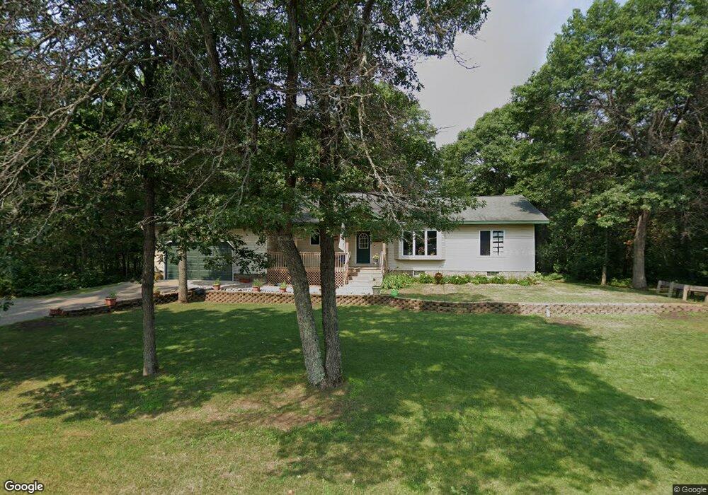
14577 White Pine Dr Baxter, MN 56425
Estimated Value: $413,000 - $504,000
3
Beds
3
Baths
1,896
Sq Ft
$248/Sq Ft
Est. Value
About This Home
This home is located at 14577 White Pine Dr, Baxter, MN 56425 and is currently estimated at $469,496, approximately $247 per square foot. 14577 White Pine Dr is a home located in Crow Wing County with nearby schools including Baxter Elementary School, Forestview Middle School, and Brainerd Senior High School.
Ownership History
Date
Name
Owned For
Owner Type
Purchase Details
Closed on
May 1, 2011
Sold by
Raleigh Peter B and Raleigh Donna M
Bought by
Carr Wyatt L and Abby Smith
Current Estimated Value
Purchase Details
Closed on
Oct 1, 2006
Sold by
Sippi Joseph J and Sippi Elizabeth A
Bought by
Raleigh Peter B and Raleigh Donna M
Purchase Details
Closed on
Nov 1, 2002
Sold by
Wolf Peter and Wolf Shari
Bought by
Sippl Joseph and Sippl Elizabeth
Purchase Details
Closed on
Oct 1, 1995
Sold by
Meyer Kathleen
Bought by
Meininger Rober
Create a Home Valuation Report for This Property
The Home Valuation Report is an in-depth analysis detailing your home's value as well as a comparison with similar homes in the area
Home Values in the Area
Average Home Value in this Area
Purchase History
| Date | Buyer | Sale Price | Title Company |
|---|---|---|---|
| Carr Wyatt L | $189,900 | -- | |
| Raleigh Peter B | $221,100 | -- | |
| Sippl Joseph | $185,900 | -- | |
| Meininger Rober | $5,500 | -- |
Source: Public Records
Tax History
| Year | Tax Paid | Tax Assessment Tax Assessment Total Assessment is a certain percentage of the fair market value that is determined by local assessors to be the total taxable value of land and additions on the property. | Land | Improvement |
|---|---|---|---|---|
| 2025 | $4,716 | $456,700 | $62,800 | $393,900 |
| 2024 | $4,716 | $468,400 | $60,700 | $407,700 |
| 2023 | $4,126 | $429,400 | $57,900 | $371,500 |
| 2022 | $3,818 | $389,400 | $45,000 | $344,400 |
| 2021 | $3,858 | $304,800 | $42,900 | $261,900 |
| 2020 | $3,770 | $299,900 | $46,500 | $253,400 |
| 2019 | $3,472 | $293,000 | $44,200 | $248,800 |
| 2018 | $3,210 | $277,400 | $44,400 | $233,000 |
| 2017 | $2,864 | $259,894 | $41,282 | $218,612 |
| 2016 | $2,896 | $226,100 | $32,300 | $193,800 |
| 2015 | $2,762 | $211,900 | $27,300 | $184,600 |
| 2014 | $1,240 | $194,300 | $20,600 | $173,700 |
Source: Public Records
Map
Nearby Homes
- L4B2 Wildflower Dr
- 14750 Lynwood Dr
- 14729 Wildflower Dr
- 21.8 Acres Minnesota 371
- 23.51 AC Minnesota 371
- Tract C Minnesota 371
- Tract B Minnesota 371
- 16.86 AC Minnesota 371
- Parcel A Minnesota 371
- Tract A Minnesota 371
- 14545 Grand Oaks Dr
- 15537 Edgewood Dr
- 14740 Fairway Dr
- 7010 Woida Rd
- 14943 Hemlock Dr
- TBD Fairview Rd
- 7096 Fairview Rd
- 6552 Austin Rd
- Outlot C Hwy 210
- Outlot A Hwy 210
- 14603 White Pine Dr
- Outlot A Clearwater Rd
- 7252 Clearwater Rd
- B & L2B1 Clearwater Rd
- 14590 White Pine Dr
- L2B1 Clearwater Rd
- Outlot B Clearwater Rd
- 14701 Lynwood Dr
- L2 B1 Clearwater Road Dr
- 14645 Wildflower Dr
- 14660 Lynwood Dr
- 14660 14660 Lynnwood-Drive-
- 14660 Lynwood Dr N
- L2,3,4 B1 Clearwater Rd
- L2 & 3 B1 Clearwater Rd
- A & L1B1 Clearwater Rd
- L3 B1 Clearwater Road Dr
- 14710 Lynwood Dr
- 14719 Lynwood Dr
- 14663 Wildflower Dr
Your Personal Tour Guide
Ask me questions while you tour the home.