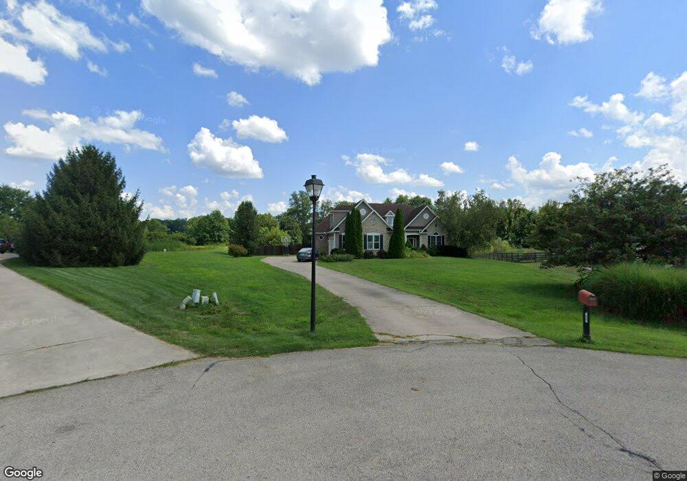
1461 Shawnee Dr Unit Lt 28 Morrow, OH 45152
Estimated Value: $614,000 - $761,000
4
Beds
5
Baths
2,638
Sq Ft
$254/Sq Ft
Est. Value
About This Home
This home is located at 1461 Shawnee Dr Unit Lt 28, Morrow, OH 45152 and is currently estimated at $669,256, approximately $253 per square foot. 1461 Shawnee Dr Unit Lt 28 is a home located in Warren County with nearby schools including Kings Junior High School and Kings High School.
Ownership History
Date
Name
Owned For
Owner Type
Purchase Details
Closed on
Nov 30, 2007
Sold by
Rademacher Phillip A and Rademacher Patti M
Bought by
Stalker Leslie and Stalker Daniel
Current Estimated Value
Home Financials for this Owner
Home Financials are based on the most recent Mortgage that was taken out on this home.
Original Mortgage
$298,000
Outstanding Balance
$190,273
Interest Rate
6.47%
Mortgage Type
Unknown
Estimated Equity
$478,983
Purchase Details
Closed on
Jan 13, 2004
Sold by
Nicely Larry
Bought by
Rademacher Phillip A and Rademacher Patti M
Home Financials for this Owner
Home Financials are based on the most recent Mortgage that was taken out on this home.
Original Mortgage
$322,350
Interest Rate
5.91%
Mortgage Type
Purchase Money Mortgage
Purchase Details
Closed on
Jan 23, 2003
Sold by
Shawhan Assoc Ltd
Bought by
Nicely Larry
Home Financials for this Owner
Home Financials are based on the most recent Mortgage that was taken out on this home.
Original Mortgage
$270,000
Interest Rate
6.13%
Mortgage Type
New Conventional
Create a Home Valuation Report for This Property
The Home Valuation Report is an in-depth analysis detailing your home's value as well as a comparison with similar homes in the area
Home Values in the Area
Average Home Value in this Area
Purchase History
| Date | Buyer | Sale Price | Title Company |
|---|---|---|---|
| Stalker Leslie | $372,500 | Attorney | |
| Rademacher Phillip A | $339,366 | -- | |
| Nicely Larry | $60,000 | -- |
Source: Public Records
Mortgage History
| Date | Status | Borrower | Loan Amount |
|---|---|---|---|
| Open | Stalker Leslie | $298,000 | |
| Previous Owner | Rademacher Phillip A | $322,350 | |
| Previous Owner | Nicely Larry | $270,000 |
Source: Public Records
Tax History Compared to Growth
Tax History
| Year | Tax Paid | Tax Assessment Tax Assessment Total Assessment is a certain percentage of the fair market value that is determined by local assessors to be the total taxable value of land and additions on the property. | Land | Improvement |
|---|---|---|---|---|
| 2024 | $8,914 | $173,390 | $23,620 | $149,770 |
| 2023 | $8,036 | $140,462 | $22,179 | $118,282 |
| 2022 | $7,948 | $140,462 | $22,180 | $118,283 |
| 2021 | $6,656 | $140,462 | $22,180 | $118,283 |
| 2020 | $7,365 | $130,060 | $20,538 | $109,522 |
| 2019 | $7,543 | $130,060 | $20,538 | $109,522 |
| 2018 | $7,477 | $130,060 | $20,538 | $109,522 |
| 2017 | $8,307 | $126,147 | $19,681 | $106,467 |
| 2016 | $8,017 | $126,147 | $19,681 | $106,467 |
| 2015 | $7,263 | $126,147 | $19,681 | $106,467 |
| 2014 | $7,044 | $118,250 | $18,750 | $99,500 |
| 2013 | $7,054 | $124,190 | $19,450 | $104,740 |
Source: Public Records
Map
Nearby Homes
- 1212 Arapaho Dr
- 978 Yarrow Ln
- 905 Garden View Cir
- 952 Lavender Way
- 998 Larkspur Dr
- 986 Larkspur Dr
- 985 Larkspur Dr
- 1017 Garden View Cir
- 3205 Garden View Ct
- 3206 Garden View Cir
- 3224 Garden View Cir
- 3159 Rosemary Ct
- 3180 Sage Ct
- 2146 Shawhan Rd
- 483 Mary Ln
- 2410 Stubbs Mill Rd
- 365 Sunset Dr
- 278 Ilene Ave
- 312 E Pike St
- 5004 Ross Ridge
- 1461 Shawnee Dr
- 1453 Shawnee Dr
- 1435 Shawnee Dr
- 1462 Shawnee Dr
- 1444 Shawnee Dr
- 1407 Shawnee Dr
- 1407 Shawnee Dr Unit Lt 31
- 1434 Arapaho Dr
- 1412 Shawnee Dr
- 1412 Shawnee Dr Unit Lt 24
- 1466 Arapaho Dr Unit Lot
- 1466 Arapaho Dr
- 1402 Arapaho Dr
- 32 Shawhan Trail
- 32 Shawnee Dr
- 32 Shawnee Dr Unit Lt 32
- 1411 Shawhan Rd
- 1399 Shawhan Rd
- 1362 Shawnee Dr
- 1389 Shawhan Rd