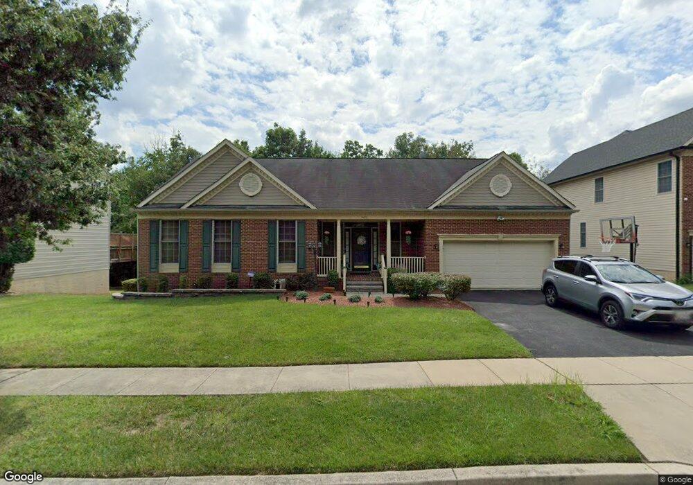
14610 Aylesford Cir Laurel, MD 20707
Estimated Value: $668,000 - $710,000
--
Bed
3
Baths
1,932
Sq Ft
$354/Sq Ft
Est. Value
About This Home
This home is located at 14610 Aylesford Cir, Laurel, MD 20707 and is currently estimated at $683,342, approximately $353 per square foot. 14610 Aylesford Cir is a home located in Prince George's County with nearby schools including Vansville Elementary School, Martin Luther King Jr. Middle School, and Laurel High School.
Ownership History
Date
Name
Owned For
Owner Type
Purchase Details
Closed on
Nov 17, 2005
Sold by
Ritaraquel Llc
Bought by
Harrison Thomas A
Current Estimated Value
Home Financials for this Owner
Home Financials are based on the most recent Mortgage that was taken out on this home.
Original Mortgage
$447,920
Outstanding Balance
$264,931
Interest Rate
7.37%
Mortgage Type
Adjustable Rate Mortgage/ARM
Estimated Equity
$418,411
Purchase Details
Closed on
Oct 7, 2002
Sold by
Ritaraquel Llc
Bought by
Ritaraquel Llc
Purchase Details
Closed on
Feb 27, 2002
Sold by
Gallo Frank and Gallo Cheryl S
Bought by
Ritaraquel Llc
Purchase Details
Closed on
Dec 30, 1996
Sold by
Bear Branch Associates Llc
Bought by
Gallo Frank and Gallo Cheryl S
Create a Home Valuation Report for This Property
The Home Valuation Report is an in-depth analysis detailing your home's value as well as a comparison with similar homes in the area
Home Values in the Area
Average Home Value in this Area
Purchase History
| Date | Buyer | Sale Price | Title Company |
|---|---|---|---|
| Harrison Thomas A | $559,900 | -- | |
| Ritaraquel Llc | -- | -- | |
| Ritaraquel Llc | $316,000 | -- | |
| Gallo Frank | $307,583 | -- |
Source: Public Records
Mortgage History
| Date | Status | Borrower | Loan Amount |
|---|---|---|---|
| Open | Harrison Thomas A | $447,920 |
Source: Public Records
Tax History Compared to Growth
Tax History
| Year | Tax Paid | Tax Assessment Tax Assessment Total Assessment is a certain percentage of the fair market value that is determined by local assessors to be the total taxable value of land and additions on the property. | Land | Improvement |
|---|---|---|---|---|
| 2025 | $10,093 | $562,200 | $187,200 | $375,000 |
| 2024 | $10,093 | $545,833 | $0 | $0 |
| 2023 | $9,733 | $529,467 | $0 | $0 |
| 2022 | $9,348 | $513,100 | $127,200 | $385,900 |
| 2021 | $8,637 | $476,933 | $0 | $0 |
| 2020 | $7,983 | $440,767 | $0 | $0 |
| 2019 | $4,574 | $404,600 | $101,100 | $303,500 |
| 2018 | $7,536 | $384,933 | $0 | $0 |
| 2017 | $7,201 | $365,267 | $0 | $0 |
| 2016 | -- | $345,600 | $0 | $0 |
| 2015 | $6,273 | $341,567 | $0 | $0 |
| 2014 | $6,273 | $337,533 | $0 | $0 |
Source: Public Records
Map
Nearby Homes
- 7808 Aylesford Ln
- 14811 Belle Ami Dr
- 7600 Lotus Ct
- 7709 Killbarron Dr
- 7610 Woodruff Ct
- 7914 Chapel Cove Dr
- 15116 Laurel Oaks Ln
- 8112 Fenwick Ct
- 14201 Oakpointe Dr
- 14206 Oxford Dr
- 15020 Cherrywood Dr
- 7631 S Arbory Ln
- 7902 Bayshore Dr Unit 32
- 7681 E Arbory Ct
- 14059 Vista Dr Unit 141C
- 14229 Bowsprit Ln Unit 501
- 7651 E Arbory Ct
- 14119 Bowsprit Ln Unit 312
- 14018 Vista Dr
- 14226 Yardarm Way Unit 107
- 14612 Aylesford Cir
- 14608 Aylesford Cir
- 14606 Aylesford Cir
- 7812 Aylesford Ln
- 7814 Aylesford Ln
- 7810 Aylesford Ln
- 7914 Aylesford Ln
- 7816 Aylesford Ln
- 14604 Aylesford Cir
- 7906 Aylesford Ln
- 7818 Aylesford Ln
- 7908 Aylesford Ln
- 7806 Aylesford Ln
- 14602 Aylesford Cir
- 14600 Aylesford Cir
- 7904 Aylesford Ln
- 14819 Belle Ami Dr
- 7813 Aylesford Ln
- 7811 Aylesford Ln
- 7815 Aylesford Ln