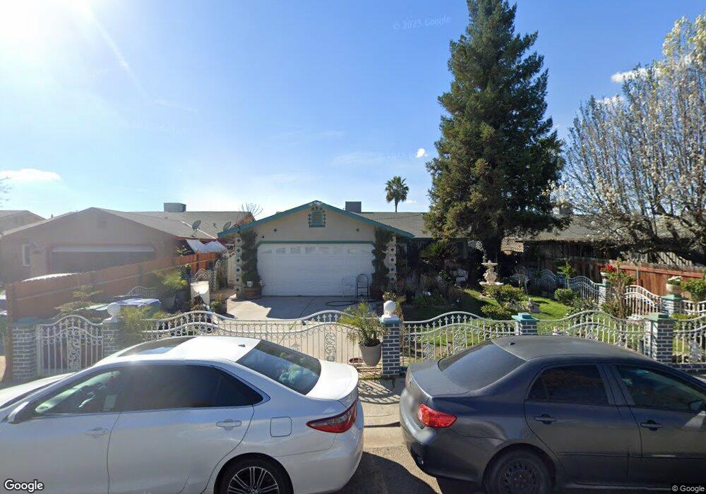
14611 Road 190 Porterville, CA 93257
Estimated Value: $254,000 - $276,519
--
Bed
--
Bath
1,233
Sq Ft
$214/Sq Ft
Est. Value
About This Home
This home is located at 14611 Road 190, Porterville, CA 93257 and is currently estimated at $263,880, approximately $214 per square foot. 14611 Road 190 is a home with nearby schools including Pleasant View Elementary School, Monache High School, and Strathmore High School.
Ownership History
Date
Name
Owned For
Owner Type
Purchase Details
Closed on
Nov 6, 1996
Sold by
Self Help Enterprises
Bought by
Alvarado Jesus and Alvarado Alicia
Current Estimated Value
Home Financials for this Owner
Home Financials are based on the most recent Mortgage that was taken out on this home.
Original Mortgage
$60,100
Outstanding Balance
$5,907
Interest Rate
8.06%
Mortgage Type
USDA
Estimated Equity
$257,973
Create a Home Valuation Report for This Property
The Home Valuation Report is an in-depth analysis detailing your home's value as well as a comparison with similar homes in the area
Home Values in the Area
Average Home Value in this Area
Purchase History
| Date | Buyer | Sale Price | Title Company |
|---|---|---|---|
| Alvarado Jesus | $16,500 | First American Title Ins Co |
Source: Public Records
Mortgage History
| Date | Status | Borrower | Loan Amount |
|---|---|---|---|
| Open | Alvarado Jesus | $60,100 |
Source: Public Records
Tax History Compared to Growth
Tax History
| Year | Tax Paid | Tax Assessment Tax Assessment Total Assessment is a certain percentage of the fair market value that is determined by local assessors to be the total taxable value of land and additions on the property. | Land | Improvement |
|---|---|---|---|---|
| 2025 | $1,085 | $114,218 | $26,874 | $87,344 |
| 2024 | $1,085 | $111,980 | $26,348 | $85,632 |
| 2023 | $1,083 | $109,785 | $25,832 | $83,953 |
| 2022 | $1,038 | $107,633 | $25,326 | $82,307 |
| 2021 | $1,023 | $105,522 | $24,829 | $80,693 |
| 2020 | $1,007 | $104,440 | $24,574 | $79,866 |
| 2019 | $985 | $102,392 | $24,092 | $78,300 |
| 2018 | $965 | $100,385 | $23,620 | $76,765 |
| 2017 | $947 | $98,417 | $23,157 | $75,260 |
| 2016 | $907 | $96,487 | $22,703 | $73,784 |
| 2015 | $871 | $95,038 | $22,362 | $72,676 |
| 2014 | $871 | $93,176 | $21,924 | $71,252 |
Source: Public Records
Map
Nearby Homes
- 14725 Walker Rd
- 0 SW Road 192 Unit# 20
- 0 SW Road 192 Unit#19
- 0 SW Road 192 Unit #21 Unit 232747
- 17771 Avenue 152
- 13250 Road 184
- 13291 Road 184
- 18925 Avenue 168
- 0 Avenue 168 Unit 237962
- 0 Avenue 168 Unit 235558
- 16847 Road 168
- 16870 Cloverdale Rd
- 249 S Westwood St
- 15247 Road 223
- 2280 W Glenn Ave
- 575 N Brandy Way
- 1448 S Westwood Rd
- 2540 W Porter Creek Ave
- 100 S Westwood St Unit 1
- 100 S Westwood St Unit 17
- 14603 Road 190
- 14616 Walker Rd
- 14599 Road 190
- 14629 Road 190
- 14624 Walker Rd
- 14606 Walker Rd
- 14632 Walker Rd
- 14635 190
- 14626 Road 190
- 14588 Walker Rd
- 14588 Walker
- 14596 Walker Rd
- 14642 Walker Rd
- 14583 Road 190
- 14643 Road 190
- 14650 Road 190
- 14580 Walker Rd
- 14654 Walker Rd
- 14636 Road 190
- 14577 Road 190