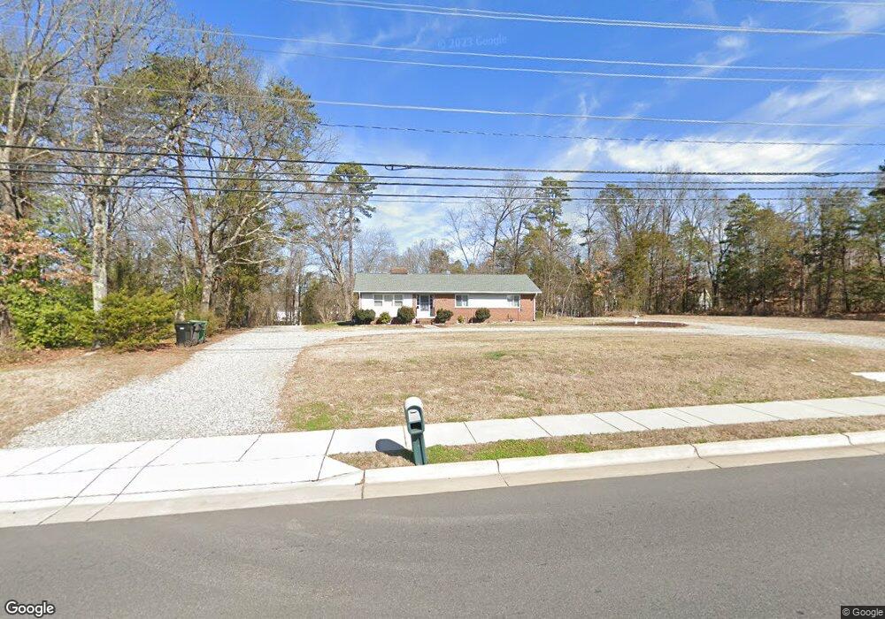
1463 Skeet Club Rd Unit R1 High Point, NC 27265
Bent Tree NeighborhoodEstimated Value: $291,000 - $454,695
3
Beds
2
Baths
1,764
Sq Ft
$200/Sq Ft
Est. Value
About This Home
This home is located at 1463 Skeet Club Rd Unit R1, High Point, NC 27265 and is currently estimated at $353,424, approximately $200 per square foot. 1463 Skeet Club Rd Unit R1 is a home located in Guilford County with nearby schools including Southwest Elementary School, Southwest Guilford Middle School, and Southwest Guilford High School.
Ownership History
Date
Name
Owned For
Owner Type
Purchase Details
Closed on
Jan 31, 2023
Sold by
Carroll Janie T
Bought by
Smith David Wayne and Smith Tonya F
Current Estimated Value
Purchase Details
Closed on
Dec 7, 2015
Sold by
Carroll Janie T and Smith David Wayne
Bought by
Carroll Janie T and Smith David Wayne
Purchase Details
Closed on
Jan 7, 2015
Sold by
Carroll Janie T
Bought by
Smith David Wayne and Smith Tonya F
Purchase Details
Closed on
Dec 30, 1992
Bought by
Carroll Janie T
Create a Home Valuation Report for This Property
The Home Valuation Report is an in-depth analysis detailing your home's value as well as a comparison with similar homes in the area
Home Values in the Area
Average Home Value in this Area
Purchase History
| Date | Buyer | Sale Price | Title Company |
|---|---|---|---|
| Smith David Wayne | -- | -- | |
| Carroll Janie T | -- | None Available | |
| Smith David Wayne | $2,000 | None Available | |
| Carroll Janie T | -- | -- |
Source: Public Records
Tax History Compared to Growth
Tax History
| Year | Tax Paid | Tax Assessment Tax Assessment Total Assessment is a certain percentage of the fair market value that is determined by local assessors to be the total taxable value of land and additions on the property. | Land | Improvement |
|---|---|---|---|---|
| 2025 | $4,654 | $337,700 | $146,500 | $191,200 |
| 2024 | $4,654 | $276,900 | $146,500 | $130,400 |
| 2023 | $4,654 | $276,900 | $146,500 | $130,400 |
| 2022 | $3,733 | $276,900 | $146,500 | $130,400 |
| 2021 | $2,186 | $158,600 | $63,000 | $95,600 |
| 2020 | $2,186 | $158,600 | $63,000 | $95,600 |
| 2019 | $2,186 | $166,400 | $0 | $0 |
| 2018 | $2,282 | $166,400 | $0 | $0 |
| 2017 | $2,282 | $166,400 | $0 | $0 |
| 2016 | $2,202 | $157,000 | $0 | $0 |
| 2015 | $2,214 | $157,000 | $0 | $0 |
| 2014 | $2,251 | $157,000 | $0 | $0 |
Source: Public Records
Map
Nearby Homes
- 3924 Braddock Rd
- 1515 Skeet Club Rd
- 3905 Wynne Brook Ct
- 3650 Single Leaf Ct
- 3007 Maple Branch Dr
- 4103 Quarterstaff Ct
- 4126 Birchgarden Dr
- 3753 Carvette Ct
- 4004 Baywater Point
- Richmond Plan at Williard Place
- 3296 Alyssa Way
- Cameron Plan at Williard Place
- Southport Plan at Williard Place
- Columbia Plan at Williard Place
- Bailey Plan at Williard Place
- 3301 Alyssa Way
- 3525 Covent Oak Ct
- 4218 Pelican St
- 4404 Essex Ct
- 3273 Alyssa Way
- 4207 Braddock Rd
- 4211 Braddock Rd
- 4205 Braddock Rd
- 4201 Braddock Rd
- 4004 Peregrine Ct
- 4215 Braddock Rd
- 4001 Peregrine Ct
- 3232 Sparrowhawk Dr
- 4022 Berkshire Ct
- 3234 Sparrowhawk Dr
- 3230 Sparrowhawk Dr
- 4217 Braddock Rd
- 4019 Berkshire Ct
- 4008 Peregrine Ct
- 3238 Sparrowhawk Dr
- 4105 Braddock Rd
- 4003 Peregrine Ct
- 4020 Berkshire Ct
- 4208 Braddock Rd
- 4010 Peregrine Ct