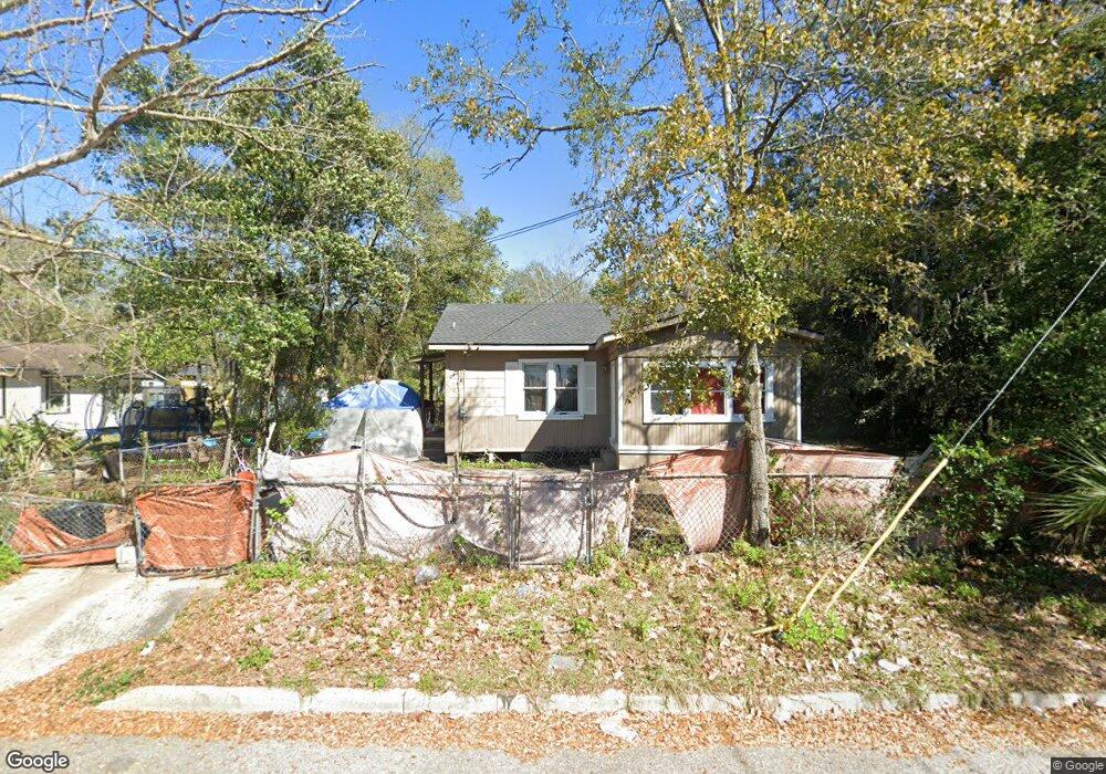
1469 E 9th St Jacksonville, FL 32206
Long Branch/Fairfield NeighborhoodEstimated Value: $74,000 - $90,000
2
Beds
1
Bath
676
Sq Ft
$118/Sq Ft
Est. Value
About This Home
This home is located at 1469 E 9th St, Jacksonville, FL 32206 and is currently estimated at $80,000, approximately $118 per square foot. 1469 E 9th St is a home located in Duval County with nearby schools including Long Branch Elementary School, Matthew W. Gilbert Middle School, and William M. Raines High School.
Ownership History
Date
Name
Owned For
Owner Type
Purchase Details
Closed on
Feb 13, 2023
Sold by
Out Of Love Llc
Bought by
Jax Fund 1 Llc
Current Estimated Value
Purchase Details
Closed on
Jan 27, 2020
Sold by
Gandy Alan
Bought by
Out Of Love Llc
Purchase Details
Closed on
Jul 16, 2015
Sold by
Magnolia Tc2 Reo Llc
Bought by
Gandy Alan
Purchase Details
Closed on
Jan 28, 2015
Sold by
County Of Duval
Bought by
Magnolia Tc 2 Reo Llc
Create a Home Valuation Report for This Property
The Home Valuation Report is an in-depth analysis detailing your home's value as well as a comparison with similar homes in the area
Home Values in the Area
Average Home Value in this Area
Purchase History
| Date | Buyer | Sale Price | Title Company |
|---|---|---|---|
| Jax Fund 1 Llc | $515,000 | Title America Real Estate Clos | |
| Out Of Love Llc | -- | None Available | |
| Gandy Alan | -- | None Available | |
| Magnolia Tc 2 Reo Llc | $9,275 | None Available |
Source: Public Records
Tax History
| Year | Tax Paid | Tax Assessment Tax Assessment Total Assessment is a certain percentage of the fair market value that is determined by local assessors to be the total taxable value of land and additions on the property. | Land | Improvement |
|---|---|---|---|---|
| 2026 | $1,197 | $47,159 | $19,680 | $27,479 |
| 2025 | $1,005 | $47,518 | $19,680 | $27,838 |
| 2024 | $747 | $46,090 | $19,680 | $26,410 |
| 2023 | $747 | $39,810 | $13,120 | $26,690 |
| 2022 | $635 | $31,425 | $10,824 | $20,601 |
| 2021 | $569 | $22,153 | $6,560 | $15,593 |
| 2020 | $505 | $21,639 | $6,560 | $15,079 |
| 2019 | $487 | $20,575 | $6,560 | $14,015 |
| 2018 | $446 | $16,201 | $4,592 | $11,609 |
| 2017 | $425 | $14,659 | $4,264 | $10,395 |
| 2016 | $394 | $11,435 | $0 | $0 |
| 2015 | $388 | $10,898 | $0 | $0 |
| 2014 | $381 | $10,415 | $0 | $0 |
Source: Public Records
Map
Nearby Homes
- 1464 Winthrop St
- 1916 Thelma St
- 1219 E 10th St
- 1148 Dyal St
- 2070 Danese St
- 2147 Brackland St
- 1646 E 14th St
- 1053 Sylvan Ct
- 1117 E 11th St
- 1045 Winthrop St
- 1058 Dyal St
- 1143 E 12th St
- 2119 Louise St
- 1045 E 11th St
- 1361 Milnor St
- 1145 E 14th St
- 1603 E 16th St
- 1221 E 16th St
- 2132 Williams St
- 1315 Franklin St
- 1511 E 9th St
- 1472 Joseph E
- 1472 Joseph St
- 1457 E 9th St
- 1450 Joseph St
- 1920 Bennett St
- 1449 E 9th St
- 1836 Bennett St
- 1444 Joseph St
- 1830 Bennett St
- 1905 Tilden St
- 1469 Joseph St
- 1481 Joseph St
- 1910 Tilden St
- 1826 Bennett St
- 1817 Egner St
- 1941 Bennett St
- 1915 Tilden St
- 1816 Bennett St
- 1504 Winthrop St
Your Personal Tour Guide
Ask me questions while you tour the home.