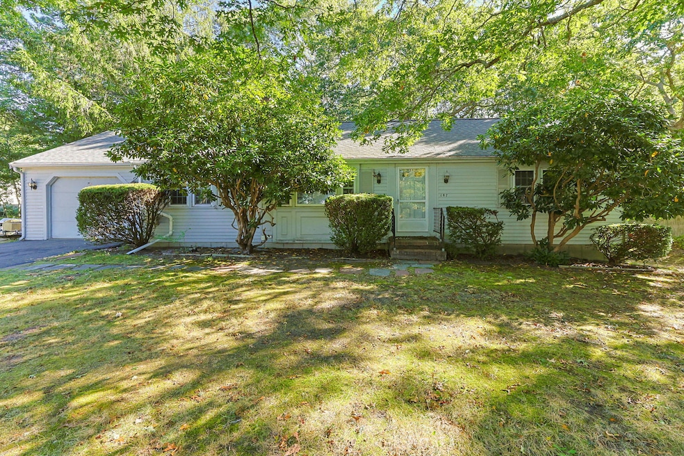


147 Captain Bacon Rd South Yarmouth, MA 02664
South Yarmouth NeighborhoodEstimated payment $3,175/month
Highlights
- Wood Flooring
- Cooling Available
- 1 Car Garage
- No HOA
- Hot Water Heating System
- 1-Story Property
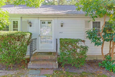
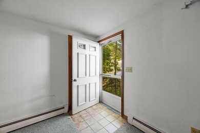
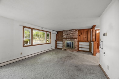
About This Home
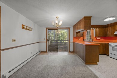
Welcome to your next opportunity! This charming 2-bedroom, 1.5-bath home is brimming with potential and ready for your personal touch. Set on a spacious lot in a well-established neighborhood, this property offers the perfect blend of convenience, value, and versatility. Step inside and discover a warm, inviting layout with two comfortable bedrooms, a full bath, and a bonus room off the half bath-ideal for office, den or creative flex space. The walk-out full basement opens up even more options-finish it to create a family room, gym, or hobby area that perfectly fits your lifestyle. Some updates are already in place, including a newer roof 2019 and energy-efficient mini splits installed in 2020-- so you can focus on cosmetic updates to truly make this home shine. Outside, you'll find a large yard offering room for gardens, play, entertaining, or simply enjoying peaceful outdoor living. Bring your vision, add a little sweat equity, and unlock all the potential this gem has to offer! Make an appointment today!
Listing Agent
William Raveis Real Estate & Home Services License #9085936 Listed on: 10/06/2025

Home Details
Home Type
- Single Family
Est. Annual Taxes
- $3,411
Year Built
- Built in 1974
Lot Details
- 0.35 Acre Lot
Parking
- 1 Car Garage
- Basement Garage
Home Design
- Poured Concrete
- Asphalt Roof
- Shingle Siding
- Clapboard
Interior Spaces
- 1,248 Sq Ft Home
- 1-Story Property
- Basement Fills Entire Space Under The House
Flooring
- Wood
- Carpet
Bedrooms and Bathrooms
- 2 Bedrooms
Utilities
- Cooling Available
- Hot Water Heating System
- Gas Water Heater
- Private Sewer
Community Details
- No Home Owners Association
Listing and Financial Details
- Assessor Parcel Number YARM M:0068 B:00080 L:0000
Map
Home Values in the Area
Average Home Value in this Area
Tax History
| Year | Tax Paid | Tax Assessment Tax Assessment Total Assessment is a certain percentage of the fair market value that is determined by local assessors to be the total taxable value of land and additions on the property. | Land | Improvement |
|---|---|---|---|---|
| 2025 | $3,411 | $481,800 | $181,800 | $300,000 |
| 2024 | $3,450 | $467,500 | $153,700 | $313,800 |
| 2023 | $3,342 | $412,100 | $133,100 | $279,000 |
| 2022 | $3,146 | $342,700 | $120,900 | $221,800 |
| 2021 | $2,951 | $308,700 | $120,900 | $187,800 |
| 2020 | $2,882 | $288,200 | $120,800 | $167,400 |
| 2019 | $2,438 | $263,700 | $120,800 | $142,900 |
| 2018 | $2,529 | $245,800 | $102,900 | $142,900 |
| 2017 | $2,419 | $241,400 | $98,500 | $142,900 |
| 2016 | $2,319 | $232,400 | $89,500 | $142,900 |
| 2015 | $2,203 | $219,400 | $89,500 | $129,900 |
Property History
| Date | Event | Price | List to Sale | Price per Sq Ft |
|---|---|---|---|---|
| 10/23/2025 10/23/25 | Pending | -- | -- | -- |
| 10/06/2025 10/06/25 | For Sale | $549,000 | -- | $440 / Sq Ft |
Purchase History
| Date | Type | Sale Price | Title Company |
|---|---|---|---|
| Deed | $273,500 | -- |
Mortgage History
| Date | Status | Loan Amount | Loan Type |
|---|---|---|---|
| Open | $77,500 | Purchase Money Mortgage |
Source: Cape Cod & Islands Association of REALTORS®
MLS Number: 22505000
APN: YARM-000068-000080
Disclaimer: Certain information contained herein is derived from information provided by parties other than Homes.com. All information provided is deemed reliable, but is not guaranteed to be accurate and should be independently verified.
![]() All data relating to real estate for sale on this page comes from the Broker Reciprocity (BR) of the Cape Cod & Islands Multiple Listing Service, Inc. Detailed information about real estate listings held by brokerage firms other than CC&I Assoc. of REALTORS®, Inc. includes the name of the listing company. Neither the listing company nor CC&I Assoc. of REALTORS®, Inc. shall be responsible for any typographical errors, misinformation, misprints and shall be held totally harmless. The Broker providing this data believes it to be correct, but advises interested parties to confirm any item before relying on it in a purchase decision. All properties are subject to prior sale, changes, or withdrawal. Copyright 2025 © Cape Cod & Islands Multiple Listing Service, Inc. All rights reserved.
All data relating to real estate for sale on this page comes from the Broker Reciprocity (BR) of the Cape Cod & Islands Multiple Listing Service, Inc. Detailed information about real estate listings held by brokerage firms other than CC&I Assoc. of REALTORS®, Inc. includes the name of the listing company. Neither the listing company nor CC&I Assoc. of REALTORS®, Inc. shall be responsible for any typographical errors, misinformation, misprints and shall be held totally harmless. The Broker providing this data believes it to be correct, but advises interested parties to confirm any item before relying on it in a purchase decision. All properties are subject to prior sale, changes, or withdrawal. Copyright 2025 © Cape Cod & Islands Multiple Listing Service, Inc. All rights reserved.