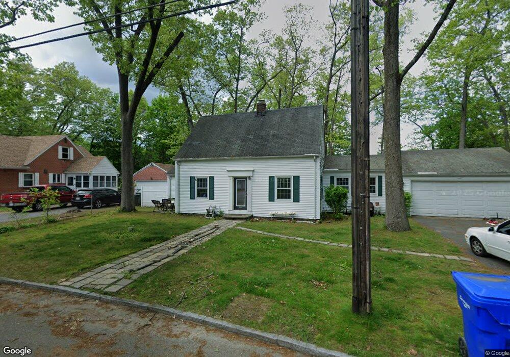
147 Carnavon Cir Springfield, MA 01109
Upper Hill NeighborhoodEstimated Value: $276,000 - $287,000
2
Beds
2
Baths
1,376
Sq Ft
$205/Sq Ft
Est. Value
About This Home
This home is located at 147 Carnavon Cir, Springfield, MA 01109 and is currently estimated at $281,859, approximately $204 per square foot. 147 Carnavon Cir is a home located in Hampden County with nearby schools including Homer Street Elementary School, John J Duggan Middle, and Springfield High School of Science and Technology.
Ownership History
Date
Name
Owned For
Owner Type
Purchase Details
Closed on
Jul 3, 2012
Sold by
Sanders William C
Bought by
Sanders Nathaniel T and Richardson Cynthia M
Current Estimated Value
Purchase Details
Closed on
Oct 8, 1971
Bought by
Sanders Nathaniel T and Richards Cynthia M
Create a Home Valuation Report for This Property
The Home Valuation Report is an in-depth analysis detailing your home's value as well as a comparison with similar homes in the area
Home Values in the Area
Average Home Value in this Area
Purchase History
| Date | Buyer | Sale Price | Title Company |
|---|---|---|---|
| Sanders Nathaniel T | -- | -- | |
| Sanders Nathaniel T | -- | -- | |
| Sanders Nathaniel T | $18,500 | -- |
Source: Public Records
Tax History
| Year | Tax Paid | Tax Assessment Tax Assessment Total Assessment is a certain percentage of the fair market value that is determined by local assessors to be the total taxable value of land and additions on the property. | Land | Improvement |
|---|---|---|---|---|
| 2025 | $4,345 | $277,100 | $41,600 | $235,500 |
| 2024 | $4,233 | $263,600 | $34,700 | $228,900 |
| 2023 | $4,080 | $239,300 | $31,500 | $207,800 |
| 2022 | $3,337 | $177,300 | $29,500 | $147,800 |
| 2021 | $3,128 | $165,500 | $26,800 | $138,700 |
| 2020 | $2,930 | $150,000 | $26,800 | $123,200 |
| 2019 | $2,846 | $144,600 | $26,800 | $117,800 |
| 2018 | $2,877 | $146,200 | $26,800 | $119,400 |
| 2017 | $2,729 | $138,800 | $24,800 | $114,000 |
| 2016 | $2,365 | $120,300 | $24,800 | $95,500 |
| 2015 | $2,109 | $107,200 | $15,500 | $91,700 |
Source: Public Records
Map
Nearby Homes
- 11 Ina St
- 87 Fenwick St
- 111 Marlborough St
- 89 Bristol St
- 135-137 Suffolk St
- 62-64 Bristol St
- 236 Pondview Dr
- 31-33 Suffolk St
- 124-126 Westford Cir
- 0 NS (24) Alden St
- 283 Wilbraham Rd
- 48-50 Dresden St
- 22 Amanda St
- 25 Dresden St
- 44 Amanda St
- 21 Westford Cir
- 54 S Shore Dr
- 19 Westford Ave
- 189 Northampton Ave
- 118 Pilgrim Rd
- 155 Carnavon Cir
- 137 Carnavon Cir
- 3 Bonnyview St
- 154 Carnavon Cir
- 11 Bonnyview St Unit 13
- 150 Carnavon Cir
- 131 Carnavon Cir
- 881 Roosevelt Ave
- 127 Carnarvon Cir
- 889 Roosevelt Ave
- 130 Fenwick St
- 31 Bonnyview St Unit 33
- 867 Roosevelt Ave
- 127 Carnavon Cir
- 20 Strathmore St
- 28 Strathmore St
- 863 Roosevelt Ave
- 37 Bonnyview St Unit 39
- 895 Roosevelt Ave
- 123 Fenwick St
Your Personal Tour Guide
Ask me questions while you tour the home.