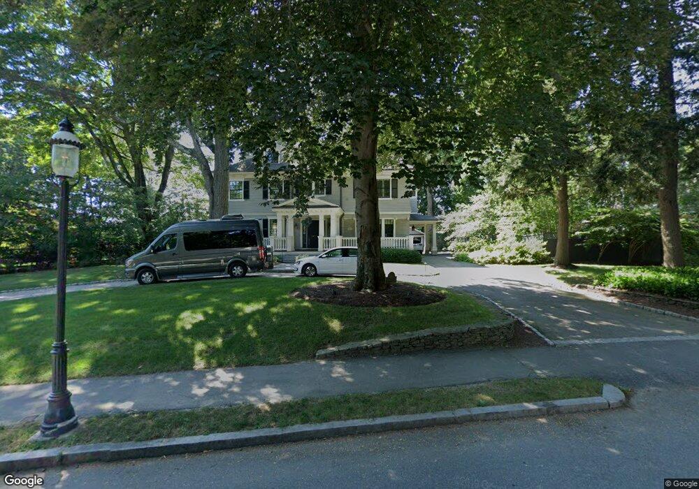
147 Prince St West Newton, MA 02465
West Newton NeighborhoodEstimated Value: $3,843,000 - $4,530,000
6
Beds
6
Baths
5,505
Sq Ft
$774/Sq Ft
Est. Value
About This Home
This home is located at 147 Prince St, West Newton, MA 02465 and is currently estimated at $4,262,079, approximately $774 per square foot. 147 Prince St is a home located in Middlesex County with nearby schools including Peirce Elementary School, F.A. Day Middle School, and Newton North High School.
Ownership History
Date
Name
Owned For
Owner Type
Purchase Details
Closed on
Mar 3, 2022
Sold by
Oran Scott I and Kessler Meryl A
Bought by
Oran Kessler Ft
Current Estimated Value
Purchase Details
Closed on
Jul 11, 2006
Sold by
147 Prince Street Rt and Litwin Frank E
Bought by
Kessler Meryl A and Oran Scott I
Purchase Details
Closed on
Apr 12, 1999
Sold by
Community Ctr School
Bought by
Lafleache Treffle and Brown Melinda J
Home Financials for this Owner
Home Financials are based on the most recent Mortgage that was taken out on this home.
Original Mortgage
$950,000
Interest Rate
6.83%
Mortgage Type
Purchase Money Mortgage
Create a Home Valuation Report for This Property
The Home Valuation Report is an in-depth analysis detailing your home's value as well as a comparison with similar homes in the area
Home Values in the Area
Average Home Value in this Area
Purchase History
| Date | Buyer | Sale Price | Title Company |
|---|---|---|---|
| Oran Kessler Ft | -- | None Available | |
| Kessler Meryl A | -- | -- | |
| 147 Prince Street Rt | -- | -- | |
| Lafleache Treffle | $650,000 | -- |
Source: Public Records
Mortgage History
| Date | Status | Borrower | Loan Amount |
|---|---|---|---|
| Previous Owner | Lafleache Treffle | $950,000 | |
| Previous Owner | Lafleache Treffle | $200,000 | |
| Previous Owner | Lafleache Treffle | $75,000 |
Source: Public Records
Tax History Compared to Growth
Tax History
| Year | Tax Paid | Tax Assessment Tax Assessment Total Assessment is a certain percentage of the fair market value that is determined by local assessors to be the total taxable value of land and additions on the property. | Land | Improvement |
|---|---|---|---|---|
| 2025 | $42,536 | $4,340,400 | $1,601,900 | $2,738,500 |
| 2024 | $41,129 | $4,214,000 | $1,555,200 | $2,658,800 |
| 2023 | $39,905 | $3,919,900 | $1,246,800 | $2,673,100 |
| 2022 | $38,182 | $3,629,500 | $1,154,400 | $2,475,100 |
| 2021 | $36,843 | $3,424,100 | $1,089,100 | $2,335,000 |
| 2020 | $35,748 | $3,424,100 | $1,089,100 | $2,335,000 |
| 2019 | $34,740 | $3,324,400 | $1,057,400 | $2,267,000 |
| 2018 | $33,902 | $3,133,300 | $937,700 | $2,195,600 |
| 2017 | $32,870 | $2,955,900 | $884,600 | $2,071,300 |
| 2016 | $31,437 | $2,762,500 | $826,700 | $1,935,800 |
| 2015 | $29,975 | $2,581,800 | $772,600 | $1,809,200 |
Source: Public Records
Map
Nearby Homes
- 10 Ruane Rd
- 222 Prince St
- 39 Valentine Park
- 40 Sewall St
- 18 Sewall St
- 308 Prince St
- 443 Chestnut St
- 12 Inis Cir
- 36 Troy Ln
- 1230 Commonwealth Ave
- 70 Bigelow Rd
- 79 Chestnut St Unit 2
- 1488 Washington St Unit 1488
- 513 Chestnut St
- 1639 Washington St
- 318 Austin St Unit A
- 0 Duncan Rd Unit 72925240
- 17 Gilbert St
- 51 Bourne St
- 429 Cherry St Unit 11