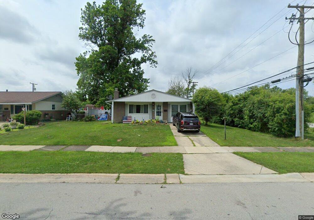
14700 Menard Ave Oak Forest, IL 60452
Estimated Value: $212,000 - $349,000
3
Beds
2
Baths
1,408
Sq Ft
$202/Sq Ft
Est. Value
About This Home
This home is located at 14700 Menard Ave, Oak Forest, IL 60452 and is currently estimated at $285,035, approximately $202 per square foot. 14700 Menard Ave is a home located in Cook County with nearby schools including Kerkstra Elementary School, Jack Hille Middle School, and Oak Forest High School.
Ownership History
Date
Name
Owned For
Owner Type
Purchase Details
Closed on
Oct 23, 2017
Sold by
Stonehouse Joyce and Stonehouse David
Bought by
Larson Nicholas A and Colon Nicole Y
Current Estimated Value
Home Financials for this Owner
Home Financials are based on the most recent Mortgage that was taken out on this home.
Original Mortgage
$116,400
Outstanding Balance
$97,999
Interest Rate
4.12%
Mortgage Type
New Conventional
Estimated Equity
$187,036
Purchase Details
Closed on
Sep 28, 2016
Sold by
Lehning Philip
Bought by
Stonehouse Joyce and Johnson Marilyn
Purchase Details
Closed on
Nov 20, 1998
Sold by
Lehning Philip
Bought by
Lehning Philip and Stonehouse Joyce
Create a Home Valuation Report for This Property
The Home Valuation Report is an in-depth analysis detailing your home's value as well as a comparison with similar homes in the area
Home Values in the Area
Average Home Value in this Area
Purchase History
| Date | Buyer | Sale Price | Title Company |
|---|---|---|---|
| Larson Nicholas A | $120,000 | Burnet Title | |
| Larson Nicholas A | $120,000 | Burnet Title | |
| Stonehouse Joyce | -- | None Available | |
| Lehning Philip | -- | -- |
Source: Public Records
Mortgage History
| Date | Status | Borrower | Loan Amount |
|---|---|---|---|
| Open | Larson Nicholas A | $116,400 | |
| Closed | Larson Nicholas A | $116,400 |
Source: Public Records
Tax History Compared to Growth
Tax History
| Year | Tax Paid | Tax Assessment Tax Assessment Total Assessment is a certain percentage of the fair market value that is determined by local assessors to be the total taxable value of land and additions on the property. | Land | Improvement |
|---|---|---|---|---|
| 2024 | $5,220 | $20,000 | $3,714 | $16,286 |
| 2023 | $5,466 | $20,000 | $3,714 | $16,286 |
| 2022 | $5,466 | $16,439 | $3,302 | $13,137 |
| 2021 | $5,776 | $17,436 | $3,301 | $14,135 |
| 2020 | $5,643 | $17,436 | $3,301 | $14,135 |
| 2019 | $5,185 | $16,302 | $3,095 | $13,207 |
| 2018 | $6,456 | $16,302 | $3,095 | $13,207 |
| 2017 | $5,758 | $17,867 | $3,095 | $14,772 |
| 2016 | $6,238 | $15,181 | $2,888 | $12,293 |
| 2015 | $1,904 | $15,181 | $2,888 | $12,293 |
| 2014 | $1,810 | $15,181 | $2,888 | $12,293 |
| 2013 | $1,661 | $16,477 | $2,888 | $13,589 |
Source: Public Records
Map
Nearby Homes
- 14511 Central Ct Unit M2
- 14525 Walden Ct Unit PH4
- 14515 Central Ct Unit M3
- 14515 Central Ct Unit G3
- 5430 Grange Ave
- 15001 Park Ave
- 15027 Park Ave
- 5813 Midlothian Turnpike
- 14947 Landings Ln
- 15251 Colina Ave
- 15100 Crescent Green Dr
- 5756 Lancaster Dr
- 6233 El Morro Ln
- 5568 Natalie Dr
- 15254 Arroyo Dr
- 16207 Long Ave
- 5340 Crescent Ln Unit C
- 5341 Crescent Ln Unit D
- 14814 Anne Ct
- 14913 Sheila Ct
- 14706 Menard Ave
- 14712 Menard Ave
- 14701 Menard Ave
- 14718 Menard Ave
- 5750 Grange Ave
- 14717 Menard Ave
- 14724 Menard Ave
- 5751 Grange Ave
- 5740 Grange Ave
- 14723 Menard Ave
- 14718 Massasoit Ave
- 14730 Menard Ave
- 5730 Grange Ave
- 14729 Menard Ave
- 14724 Massasoit Ave
- 14736 Menard Ave
- 5720 Grange Ave
- 14730 Massasoit Ave
- 14735 Menard Ave
- 14717 Massasoit Ave