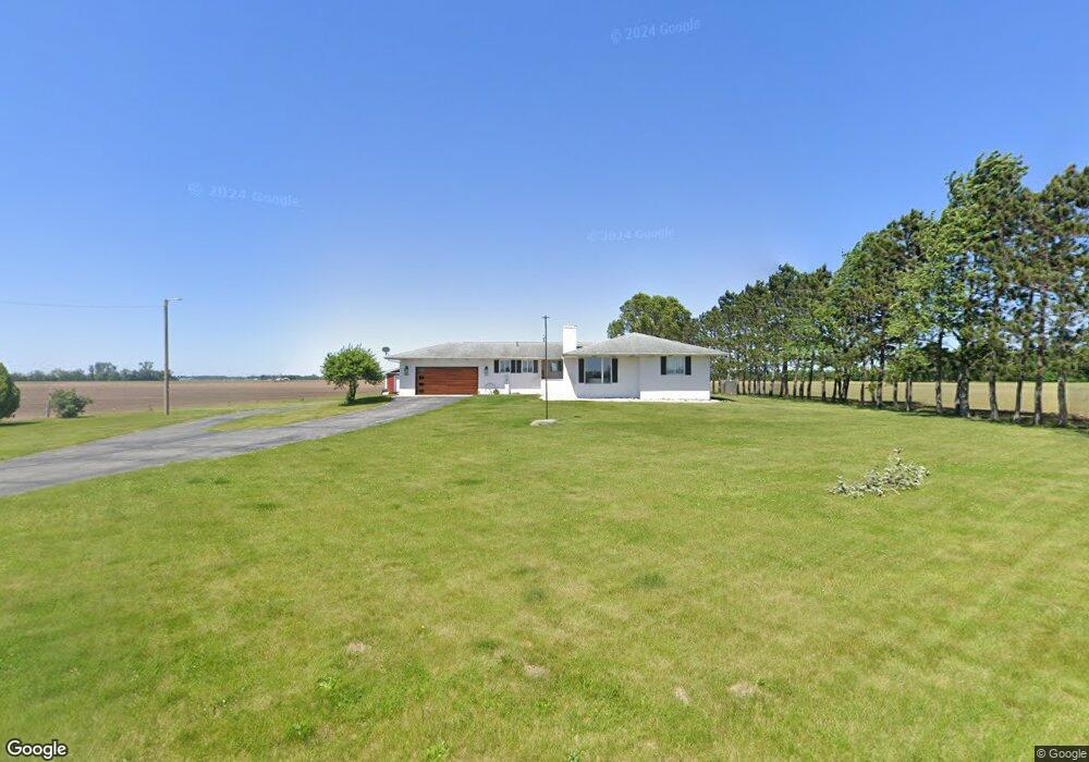
14776 S 700 W Wanatah, IN 46390
Estimated Value: $323,000 - $548,000
3
Beds
2
Baths
2,326
Sq Ft
$168/Sq Ft
Est. Value
About This Home
This home is located at 14776 S 700 W, Wanatah, IN 46390 and is currently estimated at $390,835, approximately $168 per square foot. 14776 S 700 W is a home located in LaPorte County.
Ownership History
Date
Name
Owned For
Owner Type
Purchase Details
Closed on
Dec 20, 2021
Sold by
Ovid W Hunsley Marital Trust
Bought by
Principe Kyle and Principe Cassandra
Current Estimated Value
Home Financials for this Owner
Home Financials are based on the most recent Mortgage that was taken out on this home.
Original Mortgage
$225,000
Outstanding Balance
$206,578
Interest Rate
2.98%
Mortgage Type
New Conventional
Estimated Equity
$184,257
Purchase Details
Closed on
Aug 24, 2015
Sold by
Hunsley Patricia R
Bought by
Hunsley Patricia R and Ovid W Hunsley Living Trust
Create a Home Valuation Report for This Property
The Home Valuation Report is an in-depth analysis detailing your home's value as well as a comparison with similar homes in the area
Home Values in the Area
Average Home Value in this Area
Purchase History
| Date | Buyer | Sale Price | Title Company |
|---|---|---|---|
| Principe Kyle | -- | Meridian Title | |
| Hunsley Patricia R | -- | None Available |
Source: Public Records
Mortgage History
| Date | Status | Borrower | Loan Amount |
|---|---|---|---|
| Open | Principe Kyle | $225,000 |
Source: Public Records
Tax History Compared to Growth
Tax History
| Year | Tax Paid | Tax Assessment Tax Assessment Total Assessment is a certain percentage of the fair market value that is determined by local assessors to be the total taxable value of land and additions on the property. | Land | Improvement |
|---|---|---|---|---|
| 2024 | $1,590 | $243,500 | $46,500 | $197,000 |
| 2022 | $1,720 | $214,800 | $34,300 | $180,500 |
| 2021 | $1,702 | $203,300 | $33,700 | $169,600 |
| 2020 | $1,597 | $203,300 | $33,700 | $169,600 |
| 2019 | $1,529 | $198,000 | $32,000 | $166,000 |
| 2018 | $1,510 | $199,000 | $32,200 | $166,800 |
| 2017 | $1,411 | $195,600 | $32,900 | $162,700 |
| 2016 | $1,279 | $187,000 | $33,200 | $153,800 |
| 2014 | $1,340 | $189,200 | $33,500 | $155,700 |
| 2013 | $1,194 | $171,500 | $32,300 | $139,200 |
Source: Public Records
Map
Nearby Homes
- 6948 W 1700 S
- 0 W Hwy 30 Unit GNR545374
- 114 E Jersey St
- 14501 S 400 W
- 307 N Pennsylvania St
- 6465 W 1100 S
- 305 N Ohio St
- 106 N Illinois St Unit 266
- 104 W Cross St
- 627 Fieldcrest Cir
- 116 Sprunger Dr
- 207 N Washington St
- 105 Earl St
- 627 E 300 S
- 9052 W Saint Road 8
- 17622 S State Road 39
- 601 E Main St
- 9552 S Bigelow Mill Rd
- 201 E Oneida St
- 202 Genesse St