Estimated Value: $196,000 - $232,000
3
Beds
2
Baths
1,420
Sq Ft
$152/Sq Ft
Est. Value
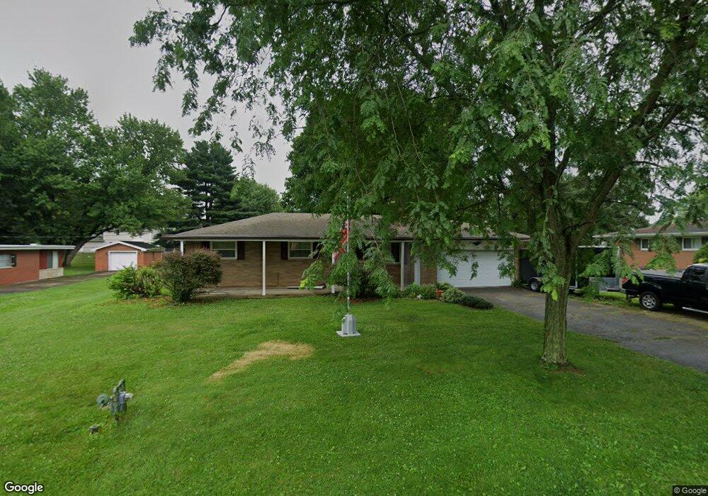
About This Home
This home is located at 148 Robert Ln, Xenia, OH 45385 and is currently estimated at $216,358, approximately $152 per square foot. 148 Robert Ln is a home located in Greene County with nearby schools including Xenia High School, Summit Academy Community School for Alternative Learners - Xenia, and Legacy Christian Academy.
Ownership History
Date
Name
Owned For
Owner Type
Purchase Details
Closed on
Jun 7, 2013
Sold by
Stewart Donald C
Bought by
Crow Paul J
Current Estimated Value
Home Financials for this Owner
Home Financials are based on the most recent Mortgage that was taken out on this home.
Original Mortgage
$103,072
Interest Rate
3.37%
Mortgage Type
FHA
Purchase Details
Closed on
Nov 3, 2006
Sold by
Perry Oliver C and Perry Phyllis A
Bought by
Stewart Donald C
Home Financials for this Owner
Home Financials are based on the most recent Mortgage that was taken out on this home.
Original Mortgage
$142,759
Interest Rate
6.45%
Mortgage Type
FHA
Purchase Details
Closed on
Sep 30, 1998
Sold by
Brown Marvin L and Brown Vivian L
Bought by
Perry Oliver C and Perry Phyllis A
Home Financials for this Owner
Home Financials are based on the most recent Mortgage that was taken out on this home.
Original Mortgage
$86,050
Interest Rate
6.98%
Mortgage Type
VA
Create a Home Valuation Report for This Property
The Home Valuation Report is an in-depth analysis detailing your home's value as well as a comparison with similar homes in the area
Home Values in the Area
Average Home Value in this Area
Purchase History
| Date | Buyer | Sale Price | Title Company |
|---|---|---|---|
| Crow Paul J | $105,000 | None Available | |
| Stewart Donald C | $145,000 | Attorney | |
| Perry Oliver C | $95,000 | -- |
Source: Public Records
Mortgage History
| Date | Status | Borrower | Loan Amount |
|---|---|---|---|
| Previous Owner | Crow Paul J | $103,072 | |
| Previous Owner | Stewart Donald C | $142,759 | |
| Previous Owner | Perry Oliver C | $86,050 |
Source: Public Records
Tax History
| Year | Tax Paid | Tax Assessment Tax Assessment Total Assessment is a certain percentage of the fair market value that is determined by local assessors to be the total taxable value of land and additions on the property. | Land | Improvement |
|---|---|---|---|---|
| 2024 | $2,953 | $61,620 | $11,220 | $50,400 |
| 2023 | $2,927 | $61,620 | $11,220 | $50,400 |
| 2022 | $2,638 | $50,360 | $10,590 | $39,770 |
| 2021 | $2,671 | $50,360 | $10,590 | $39,770 |
| 2020 | $2,565 | $50,360 | $10,590 | $39,770 |
| 2019 | $2,427 | $44,790 | $7,410 | $37,380 |
| 2018 | $2,436 | $44,790 | $7,410 | $37,380 |
| 2017 | $2,341 | $44,790 | $7,410 | $37,380 |
| 2016 | $2,342 | $42,280 | $7,410 | $34,870 |
| 2015 | $2,348 | $42,280 | $7,410 | $34,870 |
| 2014 | $2,253 | $42,280 | $7,410 | $34,870 |
Source: Public Records
Map
Nearby Homes
- 1528 June Dr
- 1351 Omard Dr
- 1777 Kylemore Dr
- 883 Omard Dr
- 1010 Bellbrook Ave
- 305-325 Bellbrook Ave
- 1715 Sioux Dr
- 161 Montana Dr
- 1272 Bellbrook Ave
- 709 N West St
- Harmony Plan at Grandstone Trace
- Newcastle Plan at Grandstone Trace
- Pendleton Plan at Grandstone Trace
- Bellamy Plan at Grandstone Trace
- Chatham Plan at Grandstone Trace
- Holcombe Plan at Grandstone Trace
- 219 Kansas Dr
- 1778 Arapaho Dr
- 1874 Pennsylvania Dr
- 311 W 3rd St
Your Personal Tour Guide
Ask me questions while you tour the home.