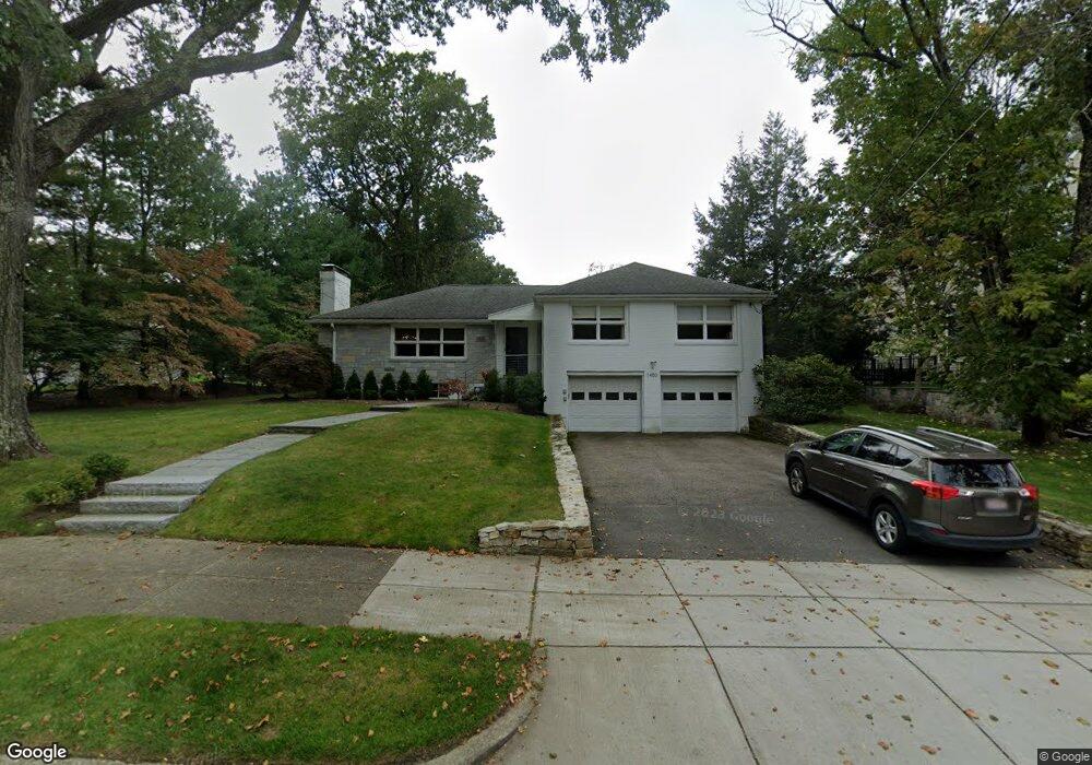
1480 Commonwealth Ave West Newton, MA 02465
West Newton NeighborhoodEstimated Value: $1,618,000 - $1,973,000
3
Beds
3
Baths
2,052
Sq Ft
$859/Sq Ft
Est. Value
About This Home
This home is located at 1480 Commonwealth Ave, West Newton, MA 02465 and is currently estimated at $1,763,365, approximately $859 per square foot. 1480 Commonwealth Ave is a home located in Middlesex County with nearby schools including Peirce Elementary School, F.A. Day Middle School, and Newton North High School.
Ownership History
Date
Name
Owned For
Owner Type
Purchase Details
Closed on
Jun 18, 2015
Sold by
Mann Janis N
Bought by
Janis N Mann Ft and Mann Janis N
Current Estimated Value
Purchase Details
Closed on
Mar 2, 2010
Sold by
Est Mann Jerold C and Mann Janis N
Bought by
Mann Janis N
Create a Home Valuation Report for This Property
The Home Valuation Report is an in-depth analysis detailing your home's value as well as a comparison with similar homes in the area
Home Values in the Area
Average Home Value in this Area
Purchase History
| Date | Buyer | Sale Price | Title Company |
|---|---|---|---|
| Janis N Mann Ft | -- | -- | |
| Mann Janis N | -- | -- |
Source: Public Records
Tax History Compared to Growth
Tax History
| Year | Tax Paid | Tax Assessment Tax Assessment Total Assessment is a certain percentage of the fair market value that is determined by local assessors to be the total taxable value of land and additions on the property. | Land | Improvement |
|---|---|---|---|---|
| 2025 | $14,486 | $1,478,200 | $1,210,100 | $268,100 |
| 2024 | $14,007 | $1,435,100 | $1,174,900 | $260,200 |
| 2023 | $13,164 | $1,293,100 | $917,400 | $375,700 |
| 2022 | $12,596 | $1,197,300 | $849,400 | $347,900 |
| 2021 | $12,153 | $1,129,500 | $801,300 | $328,200 |
| 2020 | $11,792 | $1,129,500 | $801,300 | $328,200 |
| 2019 | $11,459 | $1,096,600 | $778,000 | $318,600 |
| 2018 | $10,957 | $1,012,700 | $701,500 | $311,200 |
| 2017 | $10,624 | $955,400 | $661,800 | $293,600 |
| 2016 | $10,161 | $892,900 | $618,500 | $274,400 |
| 2015 | -- | $834,500 | $578,000 | $256,500 |
Source: Public Records
Map
Nearby Homes
- 10 Ruane Rd
- 279 Chestnut St
- 222 Prince St
- 443 Chestnut St
- 68 Mignon Rd
- 39 Valentine Park
- 18 Sewall St
- 479 Chestnut St
- 308 Prince St
- 36 Troy Ln
- 513 Chestnut St
- 1230 Commonwealth Ave
- 46 Ellis Rd
- 115 Windsor Rd
- 12 Inis Cir
- 1639 Washington St
- 70 Bigelow Rd
- 29 Montclair Rd
- 1488 Washington St Unit 1488
- 79 Chestnut St Unit 2
- 1488 Commonwealth Ave
- 32 Elizabeth Cir
- 1466 Commonwealth Ave
- 1496 Commonwealth Ave
- 1481 Commonwealth Ave
- 20 Elizabeth Cir
- 197 Fuller St
- 1489 Commonwealth Ave
- 82 Exeter St
- 63 Dartmouth St
- 69 Dartmouth St
- 29 Elizabeth Cir
- 0 Elizabeth Cir
- 88 Exeter St
- 35 Dartmouth St
- 78 Exeter St
- 56 Exeter St
- 75 Dartmouth St
- 19 Dartmouth St
- 100 Exeter St