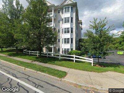
1481 Phillips Rd Unit 1106 New Bedford, MA 02745
Pine Hill Acres NeighborhoodEstimated Value: $313,000 - $358,000
2
Beds
2
Baths
1,042
Sq Ft
$314/Sq Ft
Est. Value
About This Home
This home is located at 1481 Phillips Rd Unit 1106, New Bedford, MA 02745 and is currently estimated at $326,788, approximately $313 per square foot. 1481 Phillips Rd Unit 1106 is a home located in Bristol County with nearby schools including Casimir Pulaski Elementary School, Normandin Middle School, and New Bedford High School.
Ownership History
Date
Name
Owned For
Owner Type
Purchase Details
Closed on
Jun 23, 2019
Sold by
Fawcett Suzanne
Bought by
Fawcett Suzanne and Fawcett-Sepulveda Alison
Current Estimated Value
Purchase Details
Closed on
Dec 30, 2016
Sold by
Thorpe Peter and Thorpe Jainis
Bought by
Fawcett Suzanne
Purchase Details
Closed on
Mar 28, 2008
Sold by
Schooner Cove Corp
Bought by
Thorpe Jainis and Thorpe Peter
Home Financials for this Owner
Home Financials are based on the most recent Mortgage that was taken out on this home.
Original Mortgage
$216,000
Interest Rate
5.76%
Mortgage Type
Purchase Money Mortgage
Create a Home Valuation Report for This Property
The Home Valuation Report is an in-depth analysis detailing your home's value as well as a comparison with similar homes in the area
Home Values in the Area
Average Home Value in this Area
Purchase History
| Date | Buyer | Sale Price | Title Company |
|---|---|---|---|
| Fawcett Suzanne | -- | -- | |
| Fawcett Suzanne | $205,000 | -- | |
| Thorpe Jainis | $228,000 | -- |
Source: Public Records
Mortgage History
| Date | Status | Borrower | Loan Amount |
|---|---|---|---|
| Previous Owner | Thorpe Jainis | $216,000 |
Source: Public Records
Tax History Compared to Growth
Tax History
| Year | Tax Paid | Tax Assessment Tax Assessment Total Assessment is a certain percentage of the fair market value that is determined by local assessors to be the total taxable value of land and additions on the property. | Land | Improvement |
|---|---|---|---|---|
| 2024 | $3,259 | $271,600 | $0 | $271,600 |
| 2023 | $3,305 | $231,300 | $0 | $231,300 |
| 2022 | $3,177 | $221,500 | $0 | $221,500 |
| 2021 | $3,177 | $203,800 | $0 | $203,800 |
| 2020 | $3,453 | $213,700 | $0 | $213,700 |
| 2019 | $3,330 | $202,200 | $0 | $202,200 |
| 2018 | $3,165 | $190,300 | $0 | $190,300 |
| 2017 | $3,261 | $195,400 | $0 | $195,400 |
| 2016 | $3,067 | $186,000 | $0 | $186,000 |
| 2015 | $2,926 | $186,000 | $0 | $186,000 |
| 2014 | $3,055 | $201,500 | $0 | $201,500 |
Source: Public Records
Map
Nearby Homes
- 16 Holly Tree Ln
- 1310 Phillips Rd
- 1261 Church St Unit 70
- 1261 Church St Unit 46
- 1261 Church St Unit 53
- 1251 Church St Unit 7
- 1251 Church St Unit 10
- 1216 Church St Unit 15
- 60 Avery St
- 3299 Acushnet Ave Unit 23
- 145 Heritage Dr
- 3388A Acushnet Ave
- 939 Lucy St
- 1023 Bowles St
- 2094 Phillips Rd Unit 29
- 8 Rounseville St
- 2100 Phillips Rd Unit 38
- 1068 Victoria St Unit 3
- 1143 Tacoma St
- 11 Hill Rd
- 1481 Phillips Rd Unit 1304
- 1481 Phillips Rd Unit 1303
- 1481 Phillips Rd Unit 1302
- 1481 Phillips Rd Unit 1301
- 1481 Phillips Rd Unit 1208
- 1481 Phillips Rd Unit 1207
- 1481 Phillips Rd Unit 1206
- 1481 Phillips Rd Unit 1205
- 1481 Phillips Rd Unit 1204
- 1481 Phillips Rd Unit 1203
- 1481 Phillips Rd Unit 1201
- 1481 Phillips Rd Unit 1408
- 1481 Phillips Rd Unit 1108
- 1481 Phillips Rd Unit 1407
- 1481 Phillips Rd Unit 1107
- 1481 Phillips Rd Unit 1406
- 1481 Phillips Rd Unit 1106
- 1481 Phillips Rd Unit 1405
- 1481 Phillips Rd Unit 1105
- 1481 Phillips Rd Unit 1404