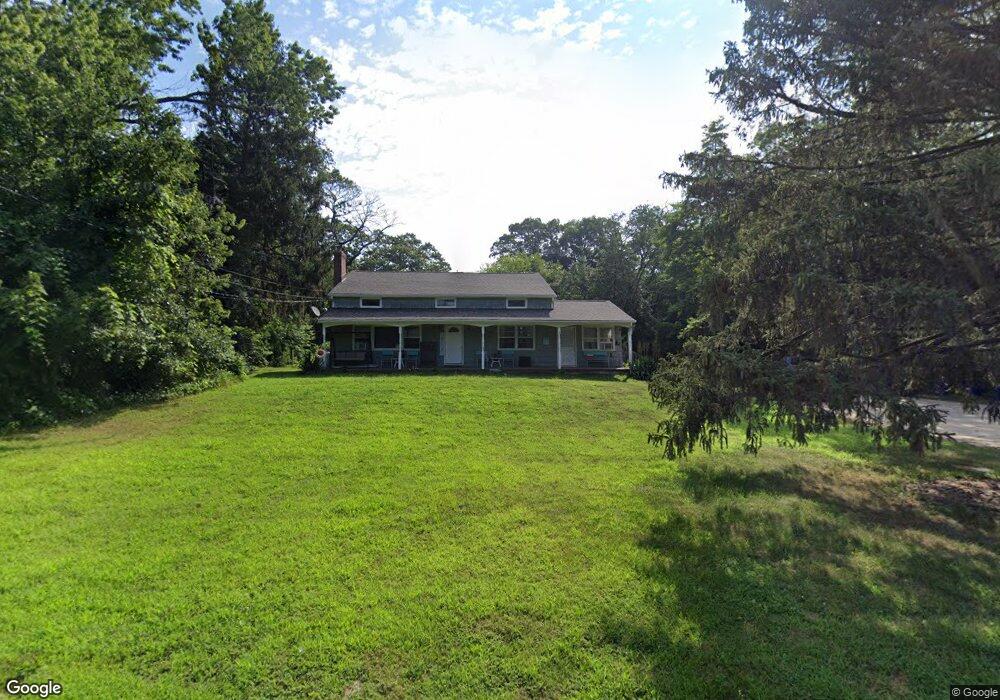
1481 Route 9 Toms River, NJ 08755
Estimated Value: $597,000 - $795,734
3
Beds
2
Baths
4,020
Sq Ft
$184/Sq Ft
Est. Value
About This Home
This home is located at 1481 Route 9, Toms River, NJ 08755 and is currently estimated at $741,684, approximately $184 per square foot. 1481 Route 9 is a home located in Ocean County with nearby schools including Ocean County Christian Academy.
Ownership History
Date
Name
Owned For
Owner Type
Purchase Details
Closed on
Mar 26, 2010
Sold by
Hsbc Bank Usa National Association
Bought by
Sanzaro Joseph L and Kacsur Angela M
Current Estimated Value
Home Financials for this Owner
Home Financials are based on the most recent Mortgage that was taken out on this home.
Original Mortgage
$200,000
Interest Rate
4.82%
Mortgage Type
Purchase Money Mortgage
Purchase Details
Closed on
Sep 14, 2009
Sold by
Cuzzi Leonard
Bought by
Hsbc Bank Usa National Association
Purchase Details
Closed on
May 31, 2005
Sold by
Johnson Robert L and Johnson Debrah P
Bought by
Cuzzi Leonard
Home Financials for this Owner
Home Financials are based on the most recent Mortgage that was taken out on this home.
Original Mortgage
$340,000
Interest Rate
8.25%
Mortgage Type
Fannie Mae Freddie Mac
Create a Home Valuation Report for This Property
The Home Valuation Report is an in-depth analysis detailing your home's value as well as a comparison with similar homes in the area
Home Values in the Area
Average Home Value in this Area
Purchase History
| Date | Buyer | Sale Price | Title Company |
|---|---|---|---|
| Sanzaro Joseph L | $224,900 | New Jersey Title Ins Co | |
| Hsbc Bank Usa National Association | -- | None Available | |
| Cuzzi Leonard | $425,000 | Fidelity National Title Insu |
Source: Public Records
Mortgage History
| Date | Status | Borrower | Loan Amount |
|---|---|---|---|
| Previous Owner | Sanzaro Joseph L | $200,000 | |
| Previous Owner | Cuzzi Leonard | $340,000 | |
| Closed | Cuzzi Leonard | $63,750 |
Source: Public Records
Tax History Compared to Growth
Tax History
| Year | Tax Paid | Tax Assessment Tax Assessment Total Assessment is a certain percentage of the fair market value that is determined by local assessors to be the total taxable value of land and additions on the property. | Land | Improvement |
|---|---|---|---|---|
| 2025 | $7,186 | $394,400 | $202,000 | $192,400 |
| 2024 | $6,827 | $394,400 | $202,000 | $192,400 |
| 2023 | $6,579 | $394,400 | $202,000 | $192,400 |
| 2022 | $6,579 | $394,400 | $202,000 | $192,400 |
| 2021 | $7,899 | $316,200 | $176,000 | $140,200 |
| 2020 | $7,864 | $316,200 | $176,000 | $140,200 |
| 2019 | $7,522 | $316,200 | $176,000 | $140,200 |
| 2018 | $7,447 | $316,200 | $176,000 | $140,200 |
| 2017 | $7,396 | $316,200 | $176,000 | $140,200 |
| 2016 | $7,222 | $316,200 | $176,000 | $140,200 |
| 2015 | $6,963 | $316,200 | $176,000 | $140,200 |
| 2014 | $6,618 | $316,200 | $176,000 | $140,200 |
Source: Public Records
Map
Nearby Homes
- 1579 Route 9
- 1599 Route 9
- 7 Webster Rd
- 25 Monroe Ave
- 109 Kristjan Ct
- 51 Clayton Ave
- 64 Monroe Ave
- 49 Green Dr
- 28 Cheddar Pink Cove
- 46 Sunset Ave
- 1216 Fox Hollow Dr
- 33 Sunflower Ln
- 94 Rolling Hills Ct
- 61 Golden Glow Circus
- 30 Swain Ave
- 100 Wicklow Ct
- 1232 Steeplechase Ct
- 74 Fox Glove Run
- 23 Wall Cress Ct
- 27 Coral Bell Hollow
- 1481 Lakewood Rd
- 1471 Route 9
- 1471 Lakewood Rd
- 1472 Route 9
- 1472 Route 9 Unit to 1482
- 1472 Lakewood Rd
- 1482 Route 9
- 1456 Lakewood Rd
- 1492 Route 9
- 1492 Lakewood Rd
- 1492 Lakewood Rd
- 14 Monroe Ave
- 10 Webster Rd
- 16 Monroe Ave
- 14 Webster Rd
- 1504 Route 9 Unit 1506
- 1454 Lakewood Rd
- 1454 U S 9
- 20 Monroe Ave
- 1504 Lakewood Rd Unit 1506