Estimated Value: $263,498 - $305,000
3
Beds
2
Baths
1,644
Sq Ft
$178/Sq Ft
Est. Value
About This Home
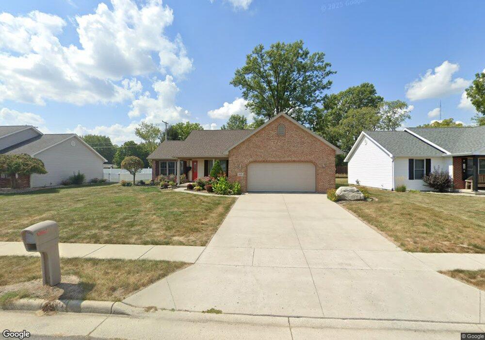
This home is located at 1485 Cessna Ave, Lima, OH 45807 and is currently estimated at $291,875, approximately $177 per square foot. 1485 Cessna Ave is a home located in Allen County with nearby schools including Elida Elementary School, Elida Middle School, and Elida High School.
Ownership History
Date
Name
Owned For
Owner Type
Purchase Details
Closed on
Dec 24, 2007
Sold by
Long James M and Long Eleanor M
Bought by
Dutton James L and Dutton Patricia A
Current Estimated Value
Home Financials for this Owner
Home Financials are based on the most recent Mortgage that was taken out on this home.
Original Mortgage
$375,127
Outstanding Balance
$170,281
Interest Rate
6.27%
Mortgage Type
Purchase Money Mortgage
Estimated Equity
$121,594
Purchase Details
Closed on
Jan 21, 2003
Sold by
Good David W
Bought by
Dutton James L and Dutton Patricia A
Create a Home Valuation Report for This Property
The Home Valuation Report is an in-depth analysis detailing your home's value as well as a comparison with similar homes in the area
Purchase History
| Date | Buyer | Sale Price | Title Company |
|---|---|---|---|
| Dutton James L | $267,100 | Attorney | |
| Dutton James L | $135,000 | -- |
Source: Public Records
Mortgage History
| Date | Status | Borrower | Loan Amount |
|---|---|---|---|
| Open | Dutton James L | $375,127 |
Source: Public Records
Tax History
| Year | Tax Paid | Tax Assessment Tax Assessment Total Assessment is a certain percentage of the fair market value that is determined by local assessors to be the total taxable value of land and additions on the property. | Land | Improvement |
|---|---|---|---|---|
| 2024 | $3,467 | $89,260 | $15,510 | $73,750 |
| 2023 | $2,715 | $64,230 | $11,170 | $53,060 |
| 2022 | $2,790 | $64,230 | $11,170 | $53,060 |
| 2021 | $2,787 | $64,230 | $11,170 | $53,060 |
| 2020 | $2,538 | $55,760 | $12,990 | $42,770 |
| 2019 | $2,538 | $55,760 | $12,990 | $42,770 |
| 2018 | $2,363 | $55,760 | $12,990 | $42,770 |
| 2017 | $2,189 | $50,200 | $12,990 | $37,210 |
| 2016 | $2,182 | $50,200 | $12,990 | $37,210 |
| 2015 | $2,209 | $50,200 | $12,990 | $37,210 |
| 2014 | $2,303 | $51,030 | $12,880 | $38,150 |
| 2013 | $2,068 | $51,030 | $12,880 | $38,150 |
Source: Public Records
Map
Nearby Homes
- 00 Allentown Rd
- 3721 Comanche
- 3619 Comanche Dr
- 3624 Comanche Dr
- 1558 Chancellor Dr
- 3660 Comanche Dr
- 3790 Comanche Dr
- 3055 Freyer Rd
- 1393 N Stevick Rd
- 3953 Willow Oak Trail
- 174 Bridle Trail
- 000 N Stevick Rd
- 0000 N Stevick Rd
- 224 Buckingham Dr
- 272 Deer Run
- 0000 Baty Rd
- 1641 Whitehall Dr
- N/A Eastown Rd N
- 37 Beaumont Place
- 2940 Koop Rd
Your Personal Tour Guide
Ask me questions while you tour the home.