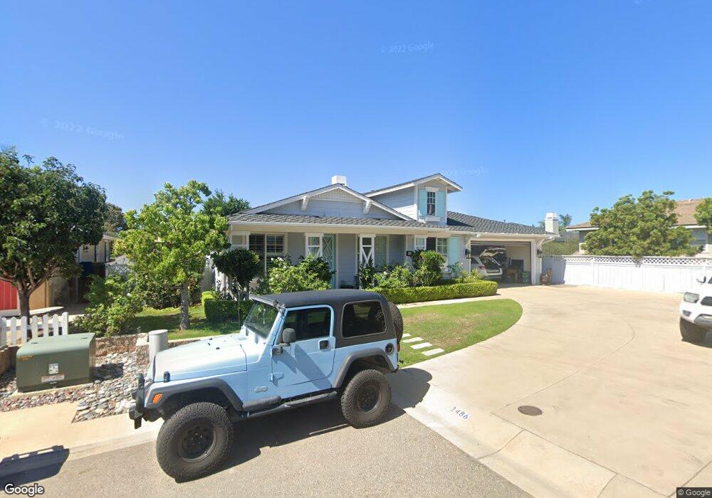
1486 Bottle Tree Ln Encinitas, CA 92024
Leucadia NeighborhoodEstimated Value: $2,338,096 - $2,826,000
3
Beds
2
Baths
2,261
Sq Ft
$1,144/Sq Ft
Est. Value
About This Home
This home is located at 1486 Bottle Tree Ln, Encinitas, CA 92024 and is currently estimated at $2,587,524, approximately $1,144 per square foot. 1486 Bottle Tree Ln is a home located in San Diego County with nearby schools including Capri Elementary School, Diegueno Middle School, and La Costa Canyon High School.
Ownership History
Date
Name
Owned For
Owner Type
Purchase Details
Closed on
Feb 26, 2013
Sold by
Yang Robert M and Yang Angie P
Bought by
Yang Robert M and Yang Angie P
Current Estimated Value
Purchase Details
Closed on
May 15, 2002
Sold by
Greystone Homes Inc
Bought by
Yang Robert M and Yang Angie P
Home Financials for this Owner
Home Financials are based on the most recent Mortgage that was taken out on this home.
Original Mortgage
$230,000
Outstanding Balance
$95,821
Interest Rate
6.74%
Mortgage Type
Unknown
Estimated Equity
$2,491,703
Create a Home Valuation Report for This Property
The Home Valuation Report is an in-depth analysis detailing your home's value as well as a comparison with similar homes in the area
Home Values in the Area
Average Home Value in this Area
Purchase History
| Date | Buyer | Sale Price | Title Company |
|---|---|---|---|
| Yang Robert M | -- | None Available | |
| Yang Robert M | $538,000 | North American Title Company |
Source: Public Records
Mortgage History
| Date | Status | Borrower | Loan Amount |
|---|---|---|---|
| Open | Yang Robert M | $230,000 |
Source: Public Records
Tax History
| Year | Tax Paid | Tax Assessment Tax Assessment Total Assessment is a certain percentage of the fair market value that is determined by local assessors to be the total taxable value of land and additions on the property. | Land | Improvement |
|---|---|---|---|---|
| 2025 | $8,764 | $794,765 | $295,451 | $499,314 |
| 2024 | $8,764 | $779,182 | $289,658 | $489,524 |
| 2023 | $8,515 | $763,905 | $283,979 | $479,926 |
| 2022 | $8,311 | $748,927 | $278,411 | $470,516 |
| 2021 | $8,173 | $734,243 | $272,952 | $461,291 |
| 2020 | $8,040 | $726,716 | $270,154 | $456,562 |
| 2019 | $7,879 | $712,467 | $264,857 | $447,610 |
| 2018 | $7,728 | $698,498 | $259,664 | $438,834 |
| 2017 | $191 | $684,803 | $254,573 | $430,230 |
| 2016 | $7,356 | $671,377 | $249,582 | $421,795 |
| 2015 | $7,225 | $661,294 | $245,834 | $415,460 |
| 2014 | $7,061 | $648,341 | $241,019 | $407,322 |
Source: Public Records
Map
Nearby Homes
- 265 Sanford St
- 273 Hillcrest Dr
- 1549 N Vulcan Ave Unit 3
- 1549 N Vulcan Ave Unit 36
- 1524 N Coast Highway 101
- 1624 N Coast Hwy 101 Unit 3
- 1624 N Coast Highway 101 Unit 2
- 1624 N Coast Highway 101 Unit 45
- 1624 N Coast Highway 101 Unit 6
- 419 Parkwood Ln
- 162 Jupiter St
- 418 Parkwood Ln
- 1475 Eolus Ave
- 1680 N Coast Highway 101 Unit 30
- 1715 Kennington Rd
- 1460 Orpheus Ave
- 251 E Glaucus St
- 1735 Tattenham Rd
- 1502 Christine Place Unit 1
- 149 W Glaucus St Unit D
- 1478 Bottle Tree Ln
- 225 Rain Tree Dr
- 237 Rain Tree Dr
- 1485 Bottle Tree Ln
- 245 Rain Tree Dr
- 1472 Bottle Tree Ln
- 1482 Coral Berry Ln
- 1488 Coral Berry Ln
- 1479 Bottle Tree Ln
- 220 Sanford St
- 1496 Coral Berry Ln
- 1473 Bottle Tree Ln
- 257 Rain Tree Dr
- 208 Sanford St
- 273 Rain Tree Dr
- 238 Rain Tree Dr
- 226 Rain Tree Dr
- 0 Sanford St Unit 5.6 210010586
- 0 Sanford St Unit 210019535
- 0 Sanford St Unit 5.6 210013367
Your Personal Tour Guide
Ask me questions while you tour the home.