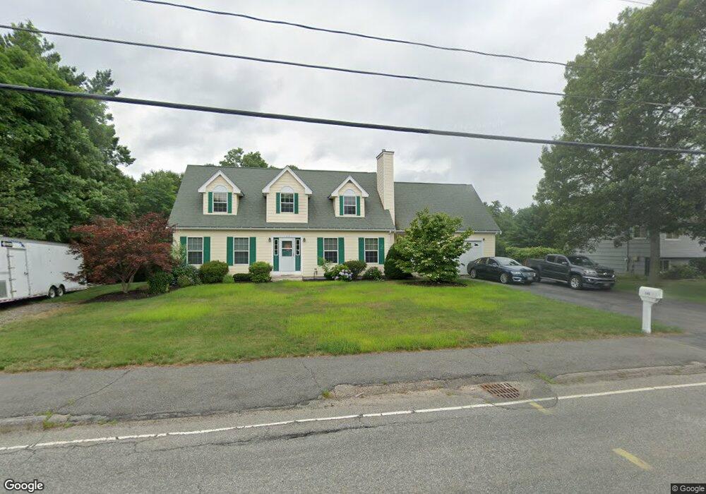
149 Chemung St Stoughton, MA 02072
Estimated Value: $707,000 - $793,450
3
Beds
3
Baths
1,958
Sq Ft
$379/Sq Ft
Est. Value
About This Home
This home is located at 149 Chemung St, Stoughton, MA 02072 and is currently estimated at $741,363, approximately $378 per square foot. 149 Chemung St is a home located in Norfolk County with nearby schools including Helen Hansen Elementary School, Dr. Robert G. O'Donnell Middle School, and Stoughton High School.
Ownership History
Date
Name
Owned For
Owner Type
Purchase Details
Closed on
May 22, 2019
Sold by
Lee Eleanor M and Lee Edward J
Bought by
Lee Ft and Lee
Current Estimated Value
Purchase Details
Closed on
Jul 28, 1977
Bought by
Lee Edward J and Lee Eleanor M
Create a Home Valuation Report for This Property
The Home Valuation Report is an in-depth analysis detailing your home's value as well as a comparison with similar homes in the area
Home Values in the Area
Average Home Value in this Area
Purchase History
| Date | Buyer | Sale Price | Title Company |
|---|---|---|---|
| Lee Ft | -- | -- | |
| Lee Ft | -- | -- | |
| Lee Ft | -- | -- | |
| Lee Edward J | -- | -- |
Source: Public Records
Mortgage History
| Date | Status | Borrower | Loan Amount |
|---|---|---|---|
| Previous Owner | Lee Edward J | $50,000 | |
| Previous Owner | Lee Edward J | $80,000 | |
| Previous Owner | Lee Edward J | $45,000 |
Source: Public Records
Tax History Compared to Growth
Tax History
| Year | Tax Paid | Tax Assessment Tax Assessment Total Assessment is a certain percentage of the fair market value that is determined by local assessors to be the total taxable value of land and additions on the property. | Land | Improvement |
|---|---|---|---|---|
| 2025 | $7,939 | $641,300 | $231,100 | $410,200 |
| 2024 | $7,721 | $606,500 | $210,600 | $395,900 |
| 2023 | $7,522 | $555,100 | $195,700 | $359,400 |
| 2022 | $7,218 | $500,900 | $178,900 | $322,000 |
| 2021 | $7,040 | $466,200 | $162,200 | $304,000 |
| 2020 | $6,858 | $460,600 | $156,600 | $304,000 |
| 2019 | $6,877 | $448,300 | $156,600 | $291,700 |
| 2018 | $6,333 | $427,600 | $149,100 | $278,500 |
| 2017 | $5,668 | $391,200 | $141,600 | $249,600 |
| 2016 | $5,596 | $373,800 | $130,500 | $243,300 |
| 2015 | $5,522 | $365,000 | $123,000 | $242,000 |
| 2014 | $5,421 | $344,400 | $111,800 | $232,600 |
Source: Public Records
Map
Nearby Homes
- 115 Joanne Rd
- 20 Sparrow Rd
- 15 Sparrow Rd
- 11 Springwood Ave
- 343 West St
- 32 Marys Way
- 2040 Central St
- 12 Eastwood Rd
- 23 Millfarm Rd
- 103 Kim Terrace Unit A
- 90 Charles Cir
- 3 Donald Rd
- 172 Wilshire Dr
- 74 Ethyl Way
- 35 Patricia Dr
- 17 Patricia Dr
- 111 Ethyl Way Unit E
- 8 Patricia Dr
- 16 Deerfield Rd
- 16 Jessica Dr Unit E