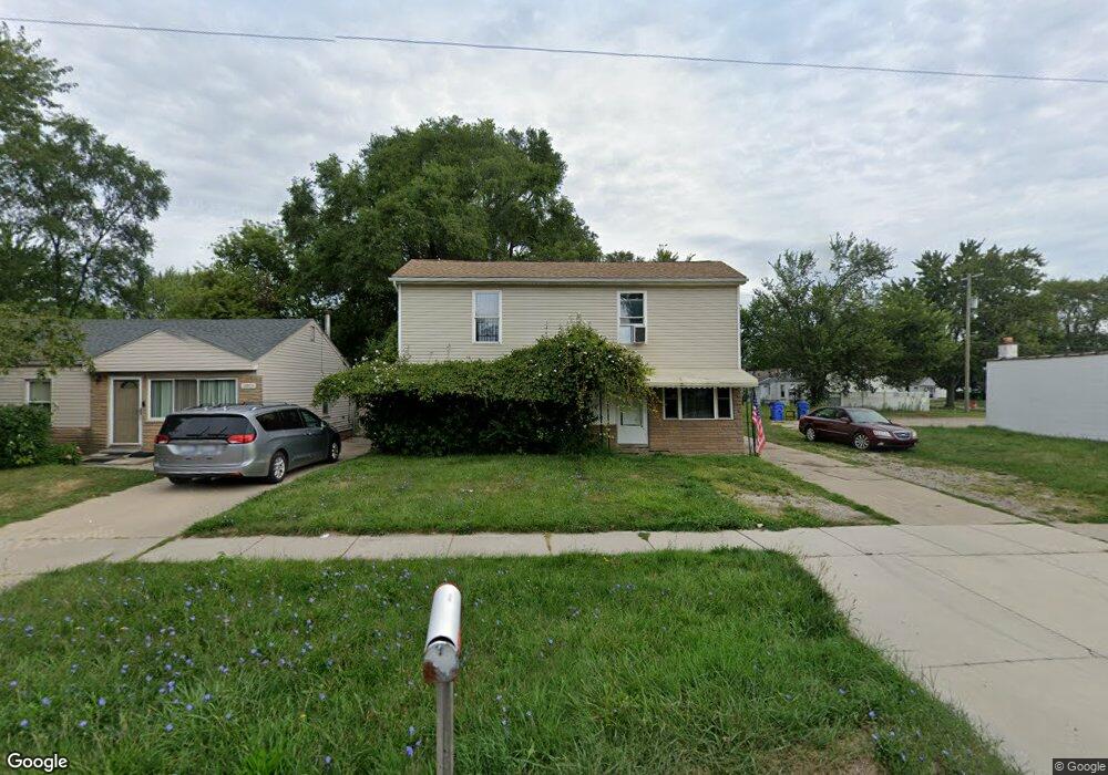
14911 E 10 Mile Rd Warren, MI 48089
Southeast Warren NeighborhoodEstimated Value: $145,000 - $183,000
3
Beds
2
Baths
1,397
Sq Ft
$115/Sq Ft
Est. Value
About This Home
This home is located at 14911 E 10 Mile Rd, Warren, MI 48089 and is currently estimated at $159,983, approximately $114 per square foot. 14911 E 10 Mile Rd is a home located in Macomb County with nearby schools including Warren Woods Tower High School.
Ownership History
Date
Name
Owned For
Owner Type
Purchase Details
Closed on
Jul 24, 2024
Sold by
Murray Joseph P
Bought by
Hamo Yousef and Hamo Sean
Current Estimated Value
Purchase Details
Closed on
May 24, 2005
Sold by
The Chase Manhattan Bank
Bought by
Murray Joseph P
Purchase Details
Closed on
May 17, 2005
Sold by
Credit Based Asset Servicing & Securitiz
Bought by
The Chase Manhattan Bank and Credit Based Asset Servicing & Securitiz
Create a Home Valuation Report for This Property
The Home Valuation Report is an in-depth analysis detailing your home's value as well as a comparison with similar homes in the area
Home Values in the Area
Average Home Value in this Area
Purchase History
| Date | Buyer | Sale Price | Title Company |
|---|---|---|---|
| Hamo Yousef | -- | None Listed On Document | |
| Hamo Yousef | -- | None Listed On Document | |
| Murray Joseph P | $75,000 | Sterling Title Agency | |
| The Chase Manhattan Bank | -- | Sterling Title Agency |
Source: Public Records
Tax History
| Year | Tax Paid | Tax Assessment Tax Assessment Total Assessment is a certain percentage of the fair market value that is determined by local assessors to be the total taxable value of land and additions on the property. | Land | Improvement |
|---|---|---|---|---|
| 2025 | $5,120 | $71,160 | $0 | $0 |
| 2024 | $25 | $74,100 | $0 | $0 |
| 2023 | $2,349 | $67,190 | $0 | $0 |
| 2022 | $2,227 | $52,020 | $0 | $0 |
| 2021 | $2,203 | $47,700 | $0 | $0 |
| 2020 | $2,133 | $43,910 | $0 | $0 |
| 2019 | $2,061 | $42,940 | $0 | $0 |
| 2018 | $2,068 | $37,090 | $0 | $0 |
| 2017 | $1,978 | $36,850 | $4,330 | $32,520 |
| 2016 | $1,965 | $36,850 | $0 | $0 |
| 2015 | -- | $31,680 | $0 | $0 |
| 2012 | -- | $28,730 | $0 | $0 |
Source: Public Records
Map
Nearby Homes
- 25184 Tecla Ave
- 25241 Rosenbusch Blvd
- 25156 Fortuna St
- 25540 Tecla Ave
- 14670 Shirley Ave
- 25152 Leach St
- 24606 Berry Ave
- 24602 Berry Ave
- 14936 Alberta Ave
- 25815 Firwood Ave
- 25769 Village Ln Unit 18
- 24523 Hayes Ave
- 14921 Eleanor Ave
- 24845 Grove Ave
- 25883 Village Ln Unit 9
- 24500 Hayes Ave
- 24831 Cottage Ln
- 25031 Fern St
- 24624 Melody Rd
- 25672 Wiseman St
- 14903 Ten Mile
- 14903 E 10 Mile Rd
- 14893 E 10 Mile Rd
- 25106 Tecla Ave
- 25107 Rosenbusch Blvd
- 25112 Tecla Ave Unit Bldg-Unit
- 25112 Tecla Ave
- 25115 Rosenbusch Blvd
- 25118 Tecla Ave
- 25123 Rosenbusch Blvd
- 14912 E 10 Mile Rd
- 14908 E 10 Mile Rd
- 14922 E 10 Mile Rd
- 25124 Tecla Ave
- 14926 E 10 Mile Rd
- 14926 E 10 Mile Rd Unit ID1032312P
- 14926 E 10 Mile Rd
- 14926 E 10 Mile Rd Unit ID1032309P
- 25131 Rosenbusch Blvd
- 25105 Tecla Ave
Your Personal Tour Guide
Ask me questions while you tour the home.