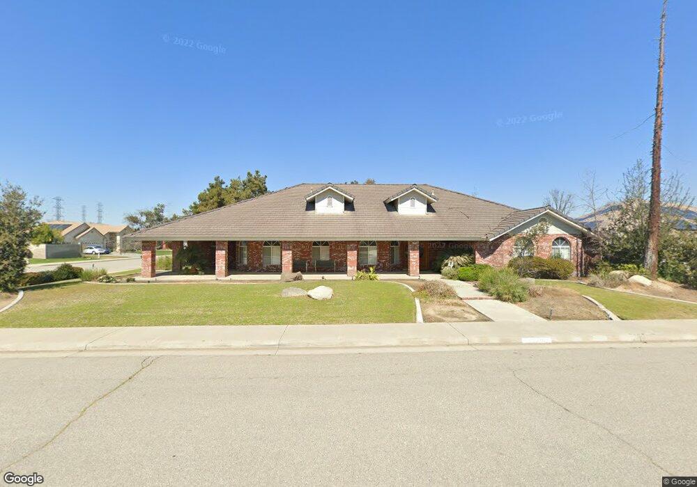
14916 David Ct Bakersfield, CA 93314
Estimated Value: $640,719 - $853,000
5
Beds
3
Baths
3,188
Sq Ft
$225/Sq Ft
Est. Value
About This Home
This home is located at 14916 David Ct, Bakersfield, CA 93314 and is currently estimated at $718,180, approximately $225 per square foot. 14916 David Ct is a home located in Kern County with nearby schools including Independence Elementary School, Freedom Middle School, and Frontier High School.
Ownership History
Date
Name
Owned For
Owner Type
Purchase Details
Closed on
May 16, 2017
Sold by
Artz Michael Steven
Bought by
Artz Michael and The Michael Artz Living Trust
Current Estimated Value
Purchase Details
Closed on
Mar 20, 2015
Sold by
Artz Michael Steven
Bought by
Artz Michael Steven
Home Financials for this Owner
Home Financials are based on the most recent Mortgage that was taken out on this home.
Original Mortgage
$205,725
Outstanding Balance
$157,390
Interest Rate
3.65%
Mortgage Type
New Conventional
Estimated Equity
$560,790
Purchase Details
Closed on
Aug 2, 2013
Sold by
Artz Cheryl Kay
Bought by
Artz Michael Steven
Purchase Details
Closed on
Feb 28, 1994
Sold by
Renfrow Inc
Bought by
Artz Michael Steven and Artz Cheryl Kay
Home Financials for this Owner
Home Financials are based on the most recent Mortgage that was taken out on this home.
Original Mortgage
$251,000
Interest Rate
7.09%
Create a Home Valuation Report for This Property
The Home Valuation Report is an in-depth analysis detailing your home's value as well as a comparison with similar homes in the area
Home Values in the Area
Average Home Value in this Area
Purchase History
| Date | Buyer | Sale Price | Title Company |
|---|---|---|---|
| Artz Michael | -- | None Available | |
| Artz Michael Steven | -- | Tsi Title Co Of Ca Inc | |
| Artz Michael Steven | -- | None Available | |
| Artz Michael Steven | $279,000 | World Title Co |
Source: Public Records
Mortgage History
| Date | Status | Borrower | Loan Amount |
|---|---|---|---|
| Open | Artz Michael Steven | $205,725 | |
| Closed | Artz Michael Steven | $251,000 |
Source: Public Records
Tax History
| Year | Tax Paid | Tax Assessment Tax Assessment Total Assessment is a certain percentage of the fair market value that is determined by local assessors to be the total taxable value of land and additions on the property. | Land | Improvement |
|---|---|---|---|---|
| 2025 | $6,659 | $474,183 | $76,467 | $397,716 |
| 2024 | $6,508 | $464,886 | $74,968 | $389,918 |
| 2023 | $6,508 | $455,772 | $73,499 | $382,273 |
| 2022 | $6,379 | $446,836 | $72,058 | $374,778 |
| 2021 | $6,228 | $438,076 | $70,646 | $367,430 |
| 2020 | $6,128 | $433,585 | $69,922 | $363,663 |
| 2019 | $6,024 | $433,585 | $69,922 | $363,663 |
| 2018 | $5,873 | $416,750 | $67,207 | $349,543 |
| 2017 | $5,698 | $408,580 | $65,890 | $342,690 |
| 2016 | $5,323 | $400,570 | $64,599 | $335,971 |
| 2015 | $5,246 | $394,554 | $63,629 | $330,925 |
| 2014 | $4,651 | $342,000 | $86,000 | $256,000 |
Source: Public Records
Map
Nearby Homes
- 14854 Tribute Way
- 15100 Dobbs Ave
- 14614 Tribute Way
- 14912 Henderson Ave
- 15417 Lila Rose Ct
- 14918 Thunder Valley Rd
- 15014 Thunder Valley Rd
- 15503 Marty Ave
- 2537 Ollie Ct Unit 1
- 15801 Susan Eileen Ave Unit 1
- 2425 Ollie Ct
- 15413 Carparzo Dr
- 14035 Rosedale Hwy Unit 72
- 14035 Rosedale Hwy Unit 66
- 14035 Rosedale Hwy Unit 93
- 14035 Rosedale Hwy Unit 134
- 14035 Rosedale Hwy Unit 108
- 14035 Rosedale Hwy Unit 87
- 14306 Westdale Dr
- 14508 Harvest Crest Ave
Your Personal Tour Guide
Ask me questions while you tour the home.