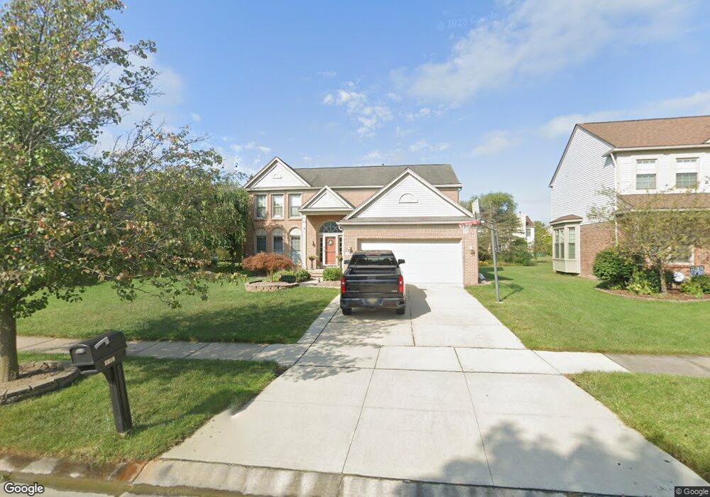
1492 Glengarry Blvd Canton, MI 48188
Estimated Value: $527,000 - $600,000
About This Home
This home is located at 1492 Glengarry Blvd, Canton, MI 48188 and is currently estimated at $568,440, approximately $215 per square foot. 1492 Glengarry Blvd is a home located in Wayne County with nearby schools including Bentley Elementary School, Canton High School, and Plymouth High School.
Ownership History
We collect this data history from publicly available records. To have your information removed, we recommend requesting removal directly through your county’s website.
Purchase Details
Purchase Details
Purchase Details
Purchase Details
Home Values in the Area
Average Home Value in this Area
Purchase History
We collect this data history from publicly available records. To have your information removed, we recommend requesting removal directly through your county’s website.
| Date | Buyer | Sale Price | Title Company |
|---|---|---|---|
| -- | None Available | ||
| $237,766 | None Available | ||
| $297,000 | None Available | ||
| $298,500 | -- |
Tax History
We collect this data history from publicly available records. To have your information removed, we recommend requesting removal directly through your county’s website.
| Year | Tax Paid | Tax Assessment Tax Assessment Total Assessment is a certain percentage of the fair market value that is determined by local assessors to be the total taxable value of land and additions on the property. | Land | Improvement |
|---|---|---|---|---|
| 2025 | $3,186 | $262,600 | $0 | $0 |
| 2024 | $3,096 | $241,600 | $0 | $0 |
| 2023 | $2,951 | $217,900 | $0 | $0 |
| 2022 | $6,399 | $194,400 | $0 | $0 |
| 2021 | $6,207 | $189,200 | $0 | $0 |
| 2020 | $6,131 | $183,800 | $0 | $0 |
| 2019 | $6,017 | $167,940 | $0 | $0 |
| 2018 | $2,508 | $159,590 | $0 | $0 |
| 2017 | $6,075 | $155,600 | $0 | $0 |
| 2016 | $5,467 | $151,400 | $0 | $0 |
| 2015 | $13,782 | $145,430 | $0 | $0 |
| 2013 | $13,445 | $140,500 | $0 | $0 |
| 2010 | -- | $134,320 | $52,620 | $81,700 |
Map
- 1675 S Sheldon Rd
- 2210 Woodmont Dr W
- 45088 Danbury Rd
- 345 Canton Center Rd
- 2481 Woodmont Dr E
- 1752 Thistle Dr
- 2053 Brookfield St
- 1774 Thistle Dr
- 1891 Vine Way Dr Unit 33
- 1921 Vine Way Dr Unit 36
- 1921 Vine Way Dr Unit 41
- 1632 Bennington Ct Unit 1632
- 1831 N Arbor Way Dr Unit 16
- 1951 N Arbor
- 1849 Wentworth Ct
- 45498 Muirfield Dr
- 2131 Vine Way Dr Unit 97
- 379 Cherry Orchard Rd Unit 105
- 44125 Michigan Ave
- 0000 Inkster Rd
- 1510 Glengarry Blvd
- 1470 Glengarry Blvd
- 1497 Kensington Dr
- 1538 Glengarry Blvd
- 1461 Kensington Dr
- 1448 Glengarry Blvd
- 1509 Kensington Dr
- 1443 Kensington Dr
- 1562 Glengarry Blvd
- 1424 Glengarry Blvd
- 1493 Glengarry Blvd
- 1563 Kensington Dr
- 1471 Glengarry Blvd
- 1427 Kensington Dr
- 1535 Glengarry Blvd
- KENSINGTON DR Kensington Dr
- 1449 Glengarry Blvd
- 1584 Glengarry Blvd
- 1402 Glengarry Blvd
- 1409 Kensington Dr
Ask me questions while you tour the home.