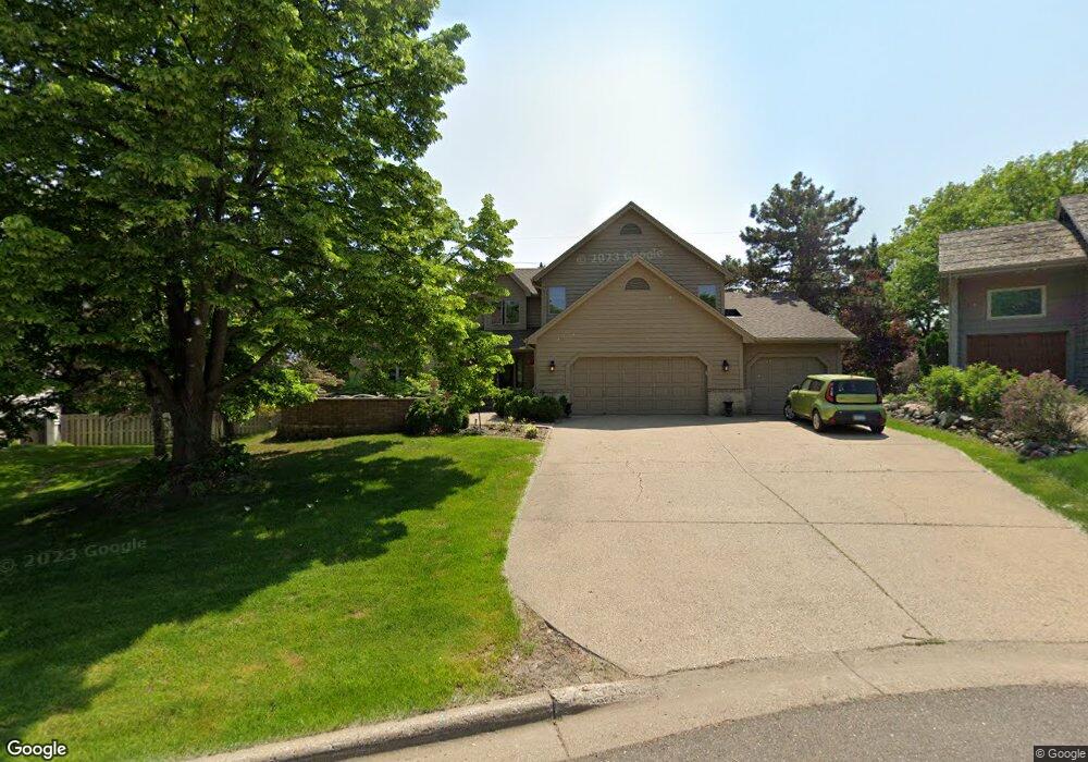
14928 Summit Oaks Cir Burnsville, MN 55337
Estimated Value: $728,829 - $783,000
5
Beds
5
Baths
3,400
Sq Ft
$223/Sq Ft
Est. Value
About This Home
This home is located at 14928 Summit Oaks Cir, Burnsville, MN 55337 and is currently estimated at $759,207, approximately $223 per square foot. 14928 Summit Oaks Cir is a home located in Dakota County with nearby schools including Echo Park Elementary School of Leadership, Engineering & Technology, Valley Middle School, and Apple Valley Senior High School.
Ownership History
Date
Name
Owned For
Owner Type
Purchase Details
Closed on
Jul 7, 2007
Sold by
Evans Melton J and Evans Karen B
Bought by
Wilson Teresa G
Current Estimated Value
Purchase Details
Closed on
Nov 1, 2001
Sold by
Alsadi Teressa G and Alsadi Husam
Bought by
Evans Melton J and Evans Karen E
Purchase Details
Closed on
Sep 1, 2000
Sold by
Wilson Kermit H and Wilson Lavonne E
Bought by
Alsadi Tereasa
Create a Home Valuation Report for This Property
The Home Valuation Report is an in-depth analysis detailing your home's value as well as a comparison with similar homes in the area
Home Values in the Area
Average Home Value in this Area
Purchase History
| Date | Buyer | Sale Price | Title Company |
|---|---|---|---|
| Wilson Teresa G | $495,000 | -- | |
| Evans Melton J | $453,500 | -- | |
| Alsadi Tereasa | $300,000 | -- |
Source: Public Records
Mortgage History
| Date | Status | Borrower | Loan Amount |
|---|---|---|---|
| Closed | Alsadi Tereasa | -- |
Source: Public Records
Tax History Compared to Growth
Tax History
| Year | Tax Paid | Tax Assessment Tax Assessment Total Assessment is a certain percentage of the fair market value that is determined by local assessors to be the total taxable value of land and additions on the property. | Land | Improvement |
|---|---|---|---|---|
| 2024 | $8,196 | $690,500 | $190,700 | $499,800 |
| 2023 | $8,196 | $661,000 | $190,800 | $470,200 |
| 2022 | $5,896 | $596,600 | $165,000 | $431,600 |
| 2021 | $5,902 | $492,600 | $143,500 | $349,100 |
| 2020 | $6,132 | $483,600 | $136,700 | $346,900 |
| 2019 | $5,452 | $489,400 | $130,200 | $359,200 |
| 2018 | $5,482 | $452,400 | $124,000 | $328,400 |
| 2017 | $5,542 | $445,600 | $118,000 | $327,600 |
| 2016 | $5,819 | $424,200 | $112,400 | $311,800 |
| 2015 | $5,502 | $441,100 | $109,100 | $332,000 |
| 2014 | -- | $427,800 | $107,100 | $320,700 |
| 2013 | -- | $407,044 | $97,966 | $309,078 |
Source: Public Records
Map
Nearby Homes
- 1516 Rushmore Dr
- 14709 White Oak Dr
- 1312 Summit Oaks Dr
- 148 Spruce Dr
- 1101 Lavon Ln
- 249 Elm Dr
- 801 Southcross Dr E
- 1012 Crystal Lake Rd E
- 441 Walnut Ln
- 1023 E 145th St
- 14659 Sherwood Place
- 712 E 151st St
- 8681 144th Street Ct
- 14231 E 143rd Ln
- 14350 Hickory Way
- 892 Redwell Ln
- 15020 Tyacke Dr
- 14764 Oak Run Ln
- 15505 Logarto Ln
- 15931 Hyland Pointe Ct
- 14924 Summit Oaks Cir
- 14932 Summit Oaks Cir
- 14920 Summit Oaks Cir
- 14912 Summit Oaks Cir
- 14916 Summit Oaks Cir
- 1558 County Road 42 E
- 1724 Rushmore Dr
- 1720 Rushmore Dr
- 1540 Parson Hill Dr
- 1530 Parson Hill Dr
- 14908 Summit Oaks Dr
- 14921 White Oak Dr
- 1728 Rushmore Dr
- 1532 Parson Hill Dr
- 1716 Rushmore Dr
- 1708 Rushmore Dr
- 14904 Summit Oaks Dr
- 14917 White Oak Dr
- 1732 Rushmore Dr
- 15000 Sunrise Ln