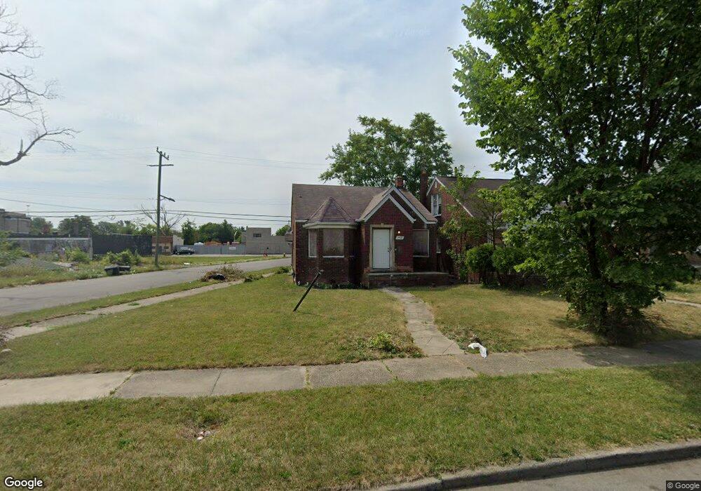
14960 Evanston St Detroit, MI 48224
Outer Drive-Hayes NeighborhoodEstimated Value: $66,000 - $82,000
--
Bed
1
Bath
929
Sq Ft
$76/Sq Ft
Est. Value
About This Home
This home is located at 14960 Evanston St, Detroit, MI 48224 and is currently estimated at $70,983, approximately $76 per square foot. 14960 Evanston St is a home located in Wayne County with nearby schools including Wayne Elementary School, Edward 'Duke' Ellington Conservatory of Music and Art, and Charles L. Spain Elementary-Middle School.
Ownership History
Date
Name
Owned For
Owner Type
Purchase Details
Closed on
Jul 12, 2021
Sold by
Detroit Land Bank Authority
Bought by
Lesley Carl
Current Estimated Value
Purchase Details
Closed on
Dec 5, 2019
Sold by
County Of Wayne
Bought by
Detroit Land Bank Authority
Purchase Details
Closed on
Sep 10, 2007
Sold by
Mcintosh Cecil
Bought by
Ransom Jonathan P
Purchase Details
Closed on
Feb 10, 2006
Sold by
Mortgage Electronic Registration Systems
Bought by
The Bank Of New York
Purchase Details
Closed on
Feb 1, 2006
Sold by
Reed Danielle
Bought by
Mortgage Electronic Registration Systems
Create a Home Valuation Report for This Property
The Home Valuation Report is an in-depth analysis detailing your home's value as well as a comparison with similar homes in the area
Home Values in the Area
Average Home Value in this Area
Purchase History
| Date | Buyer | Sale Price | Title Company |
|---|---|---|---|
| Lesley Carl | $1,100 | None Available | |
| Detroit Land Bank Authority | -- | None Available | |
| Ransom Jonathan P | $55,000 | Clearly Title | |
| The Bank Of New York | -- | None Available | |
| Mortgage Electronic Registration Systems | $46,750 | None Available |
Source: Public Records
Tax History Compared to Growth
Tax History
| Year | Tax Paid | Tax Assessment Tax Assessment Total Assessment is a certain percentage of the fair market value that is determined by local assessors to be the total taxable value of land and additions on the property. | Land | Improvement |
|---|---|---|---|---|
| 2025 | $235 | $16,000 | $0 | $0 |
| 2024 | $235 | $13,800 | $0 | $0 |
| 2023 | $347 | $2,300 | $0 | $0 |
| 2022 | $389 | $1,700 | $0 | $0 |
| 2021 | $599 | $0 | $0 | $0 |
| 2020 | $341 | $1,300 | $0 | $0 |
| 2019 | $340 | $1,200 | $0 | $0 |
| 2018 | $325 | $1,100 | $0 | $0 |
| 2017 | $21 | $1,100 | $0 | $0 |
| 2016 | $578 | $800 | $0 | $0 |
| 2015 | $79 | $800 | $0 | $0 |
| 2013 | $1,193 | $11,934 | $0 | $0 |
| 2010 | -- | $17,496 | $710 | $16,786 |
Source: Public Records
Map
Nearby Homes
- 9131 Wayburn St
- 9154 Wayburn St
- 9204 Wayburn St
- 15231 Evanston St
- 5903 Lakepointe St
- 9214 Hayes St
- 10793 E Outer Dr
- 9509 Lakepointe St
- 9500 Lakepointe St
- 9437 Beaconsfield St
- 5808 Lakepointe St
- 5777 Lakepointe St
- 9709 Lakepointe St
- 14480 Wade St
- 5747 Lakepointe St
- 9737 Lakepointe St
- 5759 Barham St
- 5968 Chalmers St
- 5960 Chalmers St
- 9833 Berkshire St
- 14950 Evanston St Unit Bldg-Unit
- 14950 Evanston St
- 14944 Evanston St
- 15000 Evanston St
- 14936 Evanston St
- 14930 Evanston St
- 15010 Evanston St
- 14955 Evanston St
- 14949 Evanston St
- 14943 Evanston St
- 14924 Evanston St
- 15016 Evanston St
- 14935 Evanston St
- 14927 Evanston St
- 15005 Evanston St
- 14916 Evanston St
- 15024 Evanston St
- 14921 Evanston St
- 15011 Evanston St
- 14929 Harper Ave