Estimated Value: $172,000 - $183,000
3
Beds
1
Bath
1,560
Sq Ft
$114/Sq Ft
Est. Value
About This Home
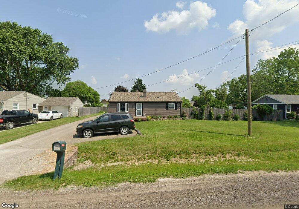
This home is located at 1498 Mark St, Flint, MI 48507 and is currently estimated at $177,258, approximately $113 per square foot. 1498 Mark St is a home located in Genesee County with nearby schools including Carman-Ainsworth High School.
Ownership History
Date
Name
Owned For
Owner Type
Purchase Details
Closed on
Dec 6, 2016
Sold by
Phoenix Capital Xxxv Llc
Bought by
Welch James and Welch Ronada
Current Estimated Value
Purchase Details
Closed on
Apr 26, 2011
Sold by
Phoenix Capital Xxxv Llc
Bought by
Welch Jamse and Welch Ronda
Home Financials for this Owner
Home Financials are based on the most recent Mortgage that was taken out on this home.
Original Mortgage
$23,000
Interest Rate
4.88%
Mortgage Type
New Conventional
Purchase Details
Closed on
Feb 3, 2011
Sold by
Hsbc Bank Usa Na
Bought by
E Phoeix Capital Xxxv Llc
Purchase Details
Closed on
Feb 24, 2010
Sold by
Irwin Jay L and Irwin Patricia J
Bought by
Hsbc Bank Usa Na
Create a Home Valuation Report for This Property
The Home Valuation Report is an in-depth analysis detailing your home's value as well as a comparison with similar homes in the area
Home Values in the Area
Average Home Value in this Area
Purchase History
| Date | Buyer | Sale Price | Title Company |
|---|---|---|---|
| Welch James | $23,000 | Lake Michigan Resource Title | |
| Welch Jamse | -- | Garrow Title | |
| E Phoeix Capital Xxxv Llc | $15,454 | None Available | |
| Hsbc Bank Usa Na | $133,806 | None Available |
Source: Public Records
Mortgage History
| Date | Status | Borrower | Loan Amount |
|---|---|---|---|
| Previous Owner | Welch Jamse | $23,000 |
Source: Public Records
Tax History
| Year | Tax Paid | Tax Assessment Tax Assessment Total Assessment is a certain percentage of the fair market value that is determined by local assessors to be the total taxable value of land and additions on the property. | Land | Improvement |
|---|---|---|---|---|
| 2025 | $1,777 | $88,700 | $0 | $0 |
| 2024 | $895 | $85,100 | $0 | $0 |
| 2023 | $854 | $70,900 | $0 | $0 |
| 2022 | $786 | $52,900 | $0 | $0 |
| 2021 | $1,569 | $47,100 | $0 | $0 |
| 2020 | $767 | $40,600 | $0 | $0 |
| 2019 | $756 | $36,700 | $0 | $0 |
| 2018 | $1,468 | $33,900 | $0 | $0 |
| 2017 | $1,400 | $33,900 | $0 | $0 |
| 2016 | $1,466 | $33,300 | $0 | $0 |
| 2015 | $1,271 | $33,100 | $0 | $0 |
| 2014 | $754 | $31,800 | $0 | $0 |
| 2012 | -- | $37,500 | $37,500 | $0 |
Source: Public Records
Map
Nearby Homes
- G4203 van Slyke Rd
- 1489 Maria St
- 4139 Moulton Dr
- 1508 W Bristol Rd
- 1151 Bristol Rd
- 2077 Kingswood Dr
- 1408 Williamsburg Rd
- 2029 Gerard St
- 1446 Stephens Ave
- 4462 Westmont Dr
- 4444 Carmanwood Dr
- 1119 W Bergin Ave
- 1203 Pickwick Place
- 1121 W Boatfield Ave
- 1111 W Mclean Ave
- 1097 W Buder Ave
- 1085 W Parkwood Ave
- 1111 Trotwood Ln
- 4460 Bristolwood Dr
- 1247 Catalina Dr
Your Personal Tour Guide
Ask me questions while you tour the home.