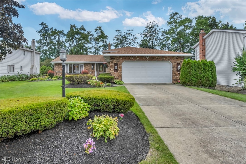
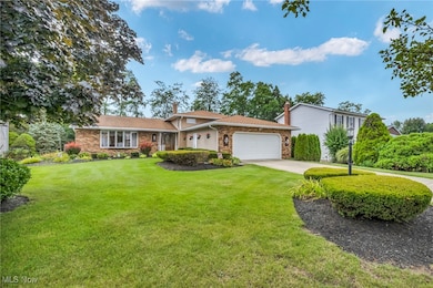
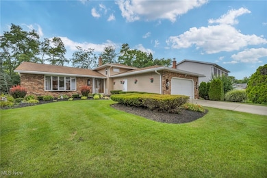
14985 Camden Cir Strongsville, OH 44136
Estimated payment $2,450/month
Highlights
- Clubhouse
- Deck
- Granite Countertops
- Strongsville High School Rated A-
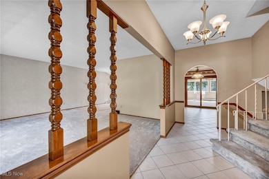
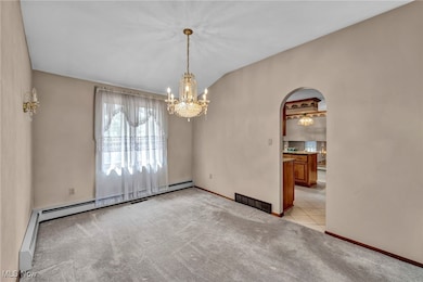
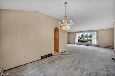
- Vaulted Ceiling
- Community Pool
About This Home
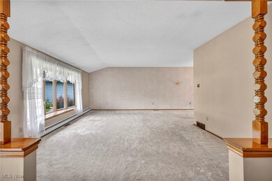
Welcome to this stunning extended split-level home in Strongsville's highly sought after Chandler Commons, offering over 3,000 sq. ft. of beautifully maintained living space, this 4-bedroom, 3 bath residence blends elegance, comfort and functionality. Step inside to a flowing floor plan that showcases a formal living and dining room, a cozy family room with fireplace, and a chef's kitchen with Amish built cabinetry and full appliance package. The four-season room with vaulted ceilings floods the home with natural light and opens to a sprawling deck and resort style landscaping, creating an entertainers dream. Upstairs, three spacious bedrooms provide ample storage, while the finished basement adds versatility. Pride of ownership shines through-this home has been meticulously cared for by its original owners. Outside, enjoy immaculate country club like grounds, and an extra-deep garage for all your needs. The community offers a pool, pavilion, tennis/pickleball, playgrounds, and more, with shopping, dining and SouthPark Mall just minutes away. Move-in ready and perfectly located
Listing Agent
Gentile Real Estate LLC Brokerage Email: multimillerteam@gmail.com, 440-552-6101 License #2013000338 Listed on: 10/20/2025
Home Details
Home Type
- Single Family
Est. Annual Taxes
- $5,014
Year Built
- Built in 1979
HOA Fees
- $40 Monthly HOA Fees
Parking
- 2 Car Attached Garage
Home Design
- Split Level Home
- Brick Exterior Construction
- Fiberglass Roof
- Asphalt Roof
- Vinyl Siding
Interior Spaces
- 2-Story Property
- Vaulted Ceiling
- Ceiling Fan
- Family Room with Fireplace
- Fire and Smoke Detector
- Finished Basement
Kitchen
- Eat-In Kitchen
- Range
- Microwave
- Dishwasher
- Granite Countertops
Bedrooms and Bathrooms
- 4 Bedrooms
- Walk-In Closet
- 3 Full Bathrooms
Laundry
- Dryer
- Washer
Utilities
- Central Air
- Baseboard Heating
Additional Features
- Deck
- 0.27 Acre Lot
Listing and Financial Details
- Assessor Parcel Number 399-23-035
Community Details
Overview
- Association fees include management, common area maintenance, recreation facilities
- Chandler Commons Association
- Chandler Commons Ph I & 02 Subdivision
Amenities
- Common Area
- Clubhouse
Recreation
- Tennis Courts
- Community Playground
- Community Pool
- Park
Map
Home Values in the Area
Average Home Value in this Area
Tax History
| Year | Tax Paid | Tax Assessment Tax Assessment Total Assessment is a certain percentage of the fair market value that is determined by local assessors to be the total taxable value of land and additions on the property. | Land | Improvement |
|---|---|---|---|---|
| 2024 | $5,014 | $116,585 | $22,015 | $94,570 |
| 2023 | $4,982 | $88,730 | $21,700 | $67,030 |
| 2022 | $4,972 | $88,730 | $21,700 | $67,030 |
| 2021 | $4,932 | $88,730 | $21,700 | $67,030 |
| 2020 | $4,460 | $72,730 | $17,780 | $54,950 |
| 2019 | $4,329 | $207,800 | $50,800 | $157,000 |
| 2018 | $3,929 | $72,730 | $17,780 | $54,950 |
| 2017 | $3,829 | $66,470 | $12,810 | $53,660 |
| 2016 | $3,798 | $66,470 | $12,810 | $53,660 |
| 2015 | $3,852 | $66,470 | $12,810 | $53,660 |
| 2014 | $3,852 | $66,470 | $12,810 | $53,660 |
Property History
| Date | Event | Price | List to Sale | Price per Sq Ft |
|---|---|---|---|---|
| 10/20/2025 10/20/25 | For Sale | $379,900 | -- | $120 / Sq Ft |
Purchase History
| Date | Type | Sale Price | Title Company |
|---|---|---|---|
| Deed | $89,900 | -- | |
| Deed | -- | -- | |
| Deed | -- | -- |
Source: MLS Now
MLS Number: 5166157
APN: 399-23-035
Disclaimer: Certain information contained herein is derived from information provided by parties other than Homes.com. All information provided is deemed reliable, but is not guaranteed to be accurate and should be independently verified.
![]() IDX information is provided exclusively for personal, non-commercial use, and may not be used for any purpose other than to identify prospective properties consumers may be interested in purchasing. Information is deemed reliable but not guaranteed.
IDX information is provided exclusively for personal, non-commercial use, and may not be used for any purpose other than to identify prospective properties consumers may be interested in purchasing. Information is deemed reliable but not guaranteed.
- 15188 Trails Landing
- 19694 Benbow Rd
- 19740 Benbow Rd
- 19813 Cross Trail S
- 15604-REAR Boston Rd
- 18229 Howe Rd
- 14292 Bent Tree Ct
- 16216 Acacia Dr
- 3550 Boston Rd
- 3087 Junior Pkwy
- 17130 Golden Star Dr
- 17567 Howe Rd
- 108 Clearwater Dr
- 2887 Nancy Cir
- 17159 Turkey Meadow Ln
- 3113 Briarcliff Dr
- 3243 Broadleaf Way
- 17682 Drake Rd
- 3941 Skyview Dr
- 17024 Bear Creek Ln
- 14292 Trenton Ave
- 17251 Howe Rd
- 17073 Drake Rd
- 17159 Turkey Meadow Ln
- 16982 Bob White Cir
- 88 Fox Hollow Ln
- 4100-4110 Skyview Dr
- 15100 Howe Rd
- 14829 Lenox Dr Unit Lenox
- 252 Cider Mill Ln
- 16323 Chatman Dr
- 14400 Howe Rd
- 4257 N Shire Ln
- 20082 Drake Rd Unit 20082
- 12601 Walnut Hill Dr
- 12445 Deer Creek Dr
- 13290 Spruce Run Dr
- 19229 Pierce Dr Unit ID1061255P
- 13000 Hampton Club Dr
- 18572 Royalton Rd
