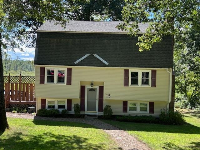
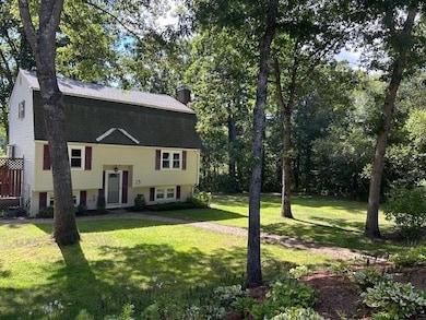
15 Alan Cir Londonderry, NH 03053
Estimated payment $3,663/month
Highlights
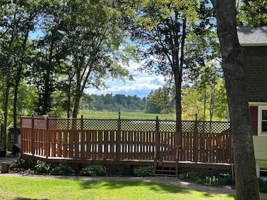
- Deck
- Wood Flooring
- Accessible Full Bathroom
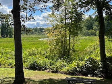
- Wooded Lot
- Main Floor Bedroom
- Hard or Low Nap Flooring
About This Home
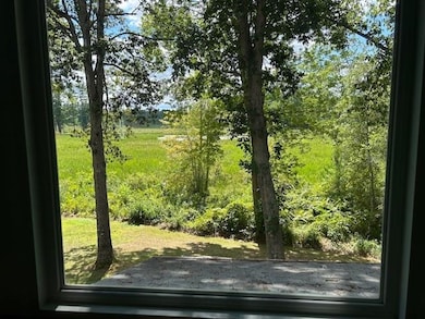
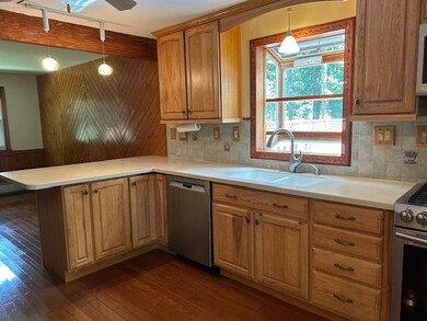
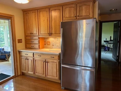
MOTIVATED SELLER will respond to all REASONABLE offers! SPECIAL FINANCING available. This house comes with a REDUCED RATE as low as 5.125% (APR 5.412%) as of 10/13/2025 through List & LockTM. This is a seller paid rate-buydown that reduces the buyer’s interest rate and monthly payment. Terms apply, see disclosures for more information. Nature lovers and anyone who enjoys a relaxing atmosphere take note. Your own personal retreat. 4BR, 2 full bath home ready for immediate occupancy. Updated kitchen with SS appliances. Access to 3 season room with spectacular view of conservation land. Living room with pellet stove. Hardwood in kitchen, living and dining rooms. 1st floor bedroom with access to full bath. 2nd floor has an additional 3 bedrooms with access to a 3/4 bath. Need more space? Large heated, finished space in basement with a 2nd pellet stove. Walkout out to rear, private yard. For summer enjoyment, there's a large round above ground pool. 2 sheds. Generator switch, 200amp electrical. EZ commute to major routes, schools and shopping. 3 bedroom septic. Quick close possible
Home Details
Home Type
- Single Family
Est. Annual Taxes
- $8,715
Year Built
- Built in 1977
Lot Details
- 1 Acre Lot
- Level Lot
- Irrigation Equipment
- Wooded Lot
- Property is zoned AR-1
Parking
- Paved Parking
Home Design
- Split Foyer
- Gambrel Roof
- Concrete Foundation
- Vinyl Siding
Interior Spaces
- Property has 3 Levels
- Ceiling Fan
- Family Room
- Dining Room
- Washer and Dryer Hookup
Kitchen
- Microwave
- Dishwasher
Flooring
- Wood
- Carpet
- Tile
Bedrooms and Bathrooms
- 4 Bedrooms
- Main Floor Bedroom
Basement
- Basement Fills Entire Space Under The House
- Interior Basement Entry
Accessible Home Design
- Accessible Full Bathroom
- Hard or Low Nap Flooring
Outdoor Features
- Deck
- Shed
Schools
- Matthew Thornton Elementary School
- Londonderry Middle School
- Londonderry Senior High School
Utilities
- Hot Water Heating System
- Generator Hookup
- Cable TV Available
Listing and Financial Details
- Legal Lot and Block 20 / 009
- Assessor Parcel Number 005
Map
Home Values in the Area
Average Home Value in this Area
Tax History
| Year | Tax Paid | Tax Assessment Tax Assessment Total Assessment is a certain percentage of the fair market value that is determined by local assessors to be the total taxable value of land and additions on the property. | Land | Improvement |
|---|---|---|---|---|
| 2024 | $7,536 | $466,900 | $199,900 | $267,000 |
| 2023 | $7,307 | $466,900 | $199,900 | $267,000 |
| 2022 | $7,104 | $384,400 | $149,800 | $234,600 |
| 2021 | $7,065 | $384,400 | $149,800 | $234,600 |
| 2020 | $6,220 | $309,300 | $112,400 | $196,900 |
| 2019 | $5,997 | $309,300 | $112,400 | $196,900 |
| 2018 | $5,777 | $265,000 | $93,700 | $171,300 |
| 2017 | $5,727 | $265,000 | $93,700 | $171,300 |
| 2016 | $5,698 | $265,000 | $93,700 | $171,300 |
| 2015 | $5,570 | $265,000 | $93,700 | $171,300 |
| 2014 | $5,589 | $265,000 | $93,700 | $171,300 |
| 2011 | -- | $267,900 | $93,700 | $174,200 |
Property History
| Date | Event | Price | List to Sale | Price per Sq Ft |
|---|---|---|---|---|
| 10/14/2025 10/14/25 | Price Changed | $559,999 | 0.0% | $269 / Sq Ft |
| 10/13/2025 10/13/25 | Price Changed | $559,900 | -2.6% | $269 / Sq Ft |
| 09/29/2025 09/29/25 | Price Changed | $575,000 | -2.5% | $276 / Sq Ft |
| 09/21/2025 09/21/25 | Price Changed | $589,900 | +0.2% | $283 / Sq Ft |
| 09/20/2025 09/20/25 | Price Changed | $589,000 | -1.7% | $283 / Sq Ft |
| 09/06/2025 09/06/25 | Price Changed | $599,000 | -1.8% | $288 / Sq Ft |
| 08/22/2025 08/22/25 | For Sale | $610,000 | -- | $293 / Sq Ft |
Purchase History
| Date | Type | Sale Price | Title Company |
|---|---|---|---|
| Warranty Deed | $119,000 | -- |
Mortgage History
| Date | Status | Loan Amount | Loan Type |
|---|---|---|---|
| Open | $201,500 | Stand Alone Refi Refinance Of Original Loan | |
| Closed | $227,000 | Unknown | |
| Closed | $236,800 | Unknown | |
| Closed | $70,000 | Unknown |
Source: PrimeMLS
MLS Number: 5057842
APN: LOND-000005-000000-000009-000020
Disclaimer: Certain information contained herein is derived from information provided by parties other than Homes.com. All information provided is deemed reliable, but is not guaranteed to be accurate and should be independently verified.
![]() Copyright 2025 PrimeMLS, Inc. All rights reserved. This information is deemed reliable, but not guaranteed. The data relating to real estate displayed on this display comes in part from the IDX Program of PrimeMLS. The information being provided is for consumers’ personal, non-commercial use and may not be used for any purpose other than to identify prospective properties consumers may be interested in purchasing.
Copyright 2025 PrimeMLS, Inc. All rights reserved. This information is deemed reliable, but not guaranteed. The data relating to real estate displayed on this display comes in part from the IDX Program of PrimeMLS. The information being provided is for consumers’ personal, non-commercial use and may not be used for any purpose other than to identify prospective properties consumers may be interested in purchasing.
- 20 Locke Mill Dr
- 4 Quincy Rd
- 4 Quincy Rd Unit A
- 19 Dixon Dr
- 13 Moose Hollow Rd
- 10 Jason Dr
- 4 Sunset Dr Unit A
- 12 Wiley Hill Rd
- 30 Windsor Dr Unit 9
- 35 Windsor Dr Unit 5
- 6 Wiley Hill Rd
- 3 Chandler Dr
- 7 Chamberlin Dr
- 88 High Range Rd
- 90 High Range Rd
- 4 Bayberry Ln
- 4 Delphi Way
- 1 Delphi Way
- 1 Delphi Way Unit 10
- 22 Cardinal Ln
- 27 Nesenkeag Dr
- 6 Dutch Dr
- 255 Derry Rd
- 23 Lawson Farm Rd
- 77 E Ridge Rd
- 246 Daniel Webster Hwy
- 360 Daniel Webster Hwy
- 2 Executive Park Dr
- 19A Loop Rd
- 540 Charles Bancroft Hwy Unit 4Belg
- 1 Vanderbilt Dr
- 10 Center St
- 4 Twin Bridge Rd
- 124 Mammoth Rd
- 3 Gilbert Dr
- 5 Pioneer Way
- 1 Innovation Way
- 1 Innovation Way Unit 103
- 3 Maple Ridge Dr Unit 221
- 2 Maple Ridge Dr Unit 28
