
Seller's Agent in 2025
Brackett Janis Group
Engel & Volkers By the Sea
(781) 608-7202
14 in this area
43 Total Sales


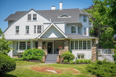

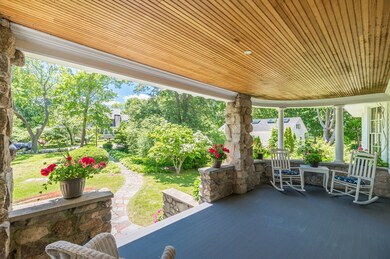

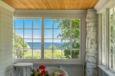
Discover the timeless elegance of 15 Brier Road - a cherished turn-of-the-century jewel perched above Gloucester’s coveted “Back Shore.” Across from Bass Rocks Golf and Tennis and a stone’s throw from Good Harbor Beach, the location is spectacular. As you arrive, salt air and the rhythm of the tides welcome you. The stately residence commands sweeping Atlantic views and brims with character—from soaring ceilings and graceful archways to an original butler’s pantry that whispers of its storied past. The richly wood-paneled pub room recalls the echoes of bygone celebrations and cherished traditions, quickly becoming a favorite among guests. A flowing, open layout offers generous space for both intimate moments and grand entertaining, while the upper-level retreat—framed by dramatic ocean vistas—invites quiet reflection. This is a home where historic charm, refined elegance, and the ever-present pulse of the sea combine to create an unforgettable coastal haven.
Last Agent to Sell the Property
Engel & Volkers By the Sea Listed on: 06/25/2025
| Date | Type | Sale Price | Title Company |
|---|---|---|---|
| Quit Claim Deed | $2,400,000 | -- | |
| Quit Claim Deed | $2,400,000 | -- | |
| Quit Claim Deed | -- | -- | |
| Quit Claim Deed | -- | -- | |
| Deed | -- | -- |
| Date | Status | Loan Amount | Loan Type |
|---|---|---|---|
| Previous Owner | $158,000 | No Value Available |
| Date | Event | Price | List to Sale | Price per Sq Ft |
|---|---|---|---|---|
| 08/26/2025 08/26/25 | Sold | $2,400,000 | 0.0% | $467 / Sq Ft |
| 07/03/2025 07/03/25 | Pending | -- | -- | -- |
| 06/25/2025 06/25/25 | For Sale | $2,400,000 | -- | $467 / Sq Ft |
| Year | Tax Paid | Tax Assessment Tax Assessment Total Assessment is a certain percentage of the fair market value that is determined by local assessors to be the total taxable value of land and additions on the property. | Land | Improvement |
|---|---|---|---|---|
| 2025 | $14,723 | $1,514,700 | $733,100 | $781,600 |
| 2024 | $14,396 | $1,479,500 | $697,900 | $781,600 |
| 2023 | $13,551 | $1,279,600 | $595,900 | $683,700 |
| 2022 | $13,122 | $1,118,700 | $519,000 | $599,700 |
| 2021 | $12,660 | $1,017,700 | $471,200 | $546,500 |
| 2020 | $12,769 | $1,035,600 | $471,200 | $564,400 |
| 2019 | $12,349 | $973,100 | $449,300 | $523,800 |
| 2018 | $12,656 | $978,800 | $438,400 | $540,400 |
| 2017 | $12,260 | $929,500 | $416,800 | $512,700 |
| 2016 | $11,887 | $873,400 | $398,900 | $474,500 |
| 2015 | $11,489 | $841,700 | $403,300 | $438,400 |
Seller's Agent in 2025
Brackett Janis Group
Engel & Volkers By the Sea
(781) 608-7202
14 in this area
43 Total Sales
Buyer's Agent in 2025
Beth Jacobs
Coldwell Banker Realty - Marblehead
(781) 820-9957
1 in this area
21 Total Sales
Source: MLS Property Information Network (MLS PIN)
MLS Number: 73396608
APN: GLOU-000070-000022
Disclaimer: Certain information contained herein is derived from information provided by parties other than Homes.com. All information provided is deemed reliable, but is not guaranteed to be accurate and should be independently verified.
![]() The property listing data and information, or the Images, set forth herein were provided to MLS Property Information Network, Inc. from third party sources, including sellers, lessors and public records, and were compiled by MLS Property Information Network, Inc. The property listing data and information, and the Images, are for the personal, non-commercial use of consumers having a good faith interest in purchasing or leasing listed properties of the type displayed to them and may not be used for any purpose other than to identify prospective properties which such consumers may have a good faith interest in purchasing or leasing. MLS Property Information Network, Inc. and its subscribers disclaim any and all representations and warranties as to the accuracy of the property listing data and information, or as to the accuracy of any of the Images, set forth herein.
The property listing data and information, or the Images, set forth herein were provided to MLS Property Information Network, Inc. from third party sources, including sellers, lessors and public records, and were compiled by MLS Property Information Network, Inc. The property listing data and information, and the Images, are for the personal, non-commercial use of consumers having a good faith interest in purchasing or leasing listed properties of the type displayed to them and may not be used for any purpose other than to identify prospective properties which such consumers may have a good faith interest in purchasing or leasing. MLS Property Information Network, Inc. and its subscribers disclaim any and all representations and warranties as to the accuracy of the property listing data and information, or as to the accuracy of any of the Images, set forth herein.
Ask me questions while you tour the home.