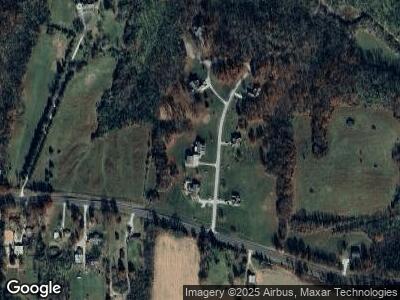
15 Brushy Ridge Ln Winfield, MO 63389
Estimated Value: $396,000 - $630,000
3
Beds
4
Baths
2,242
Sq Ft
$242/Sq Ft
Est. Value
About This Home
This home is located at 15 Brushy Ridge Ln, Winfield, MO 63389 and is currently estimated at $541,487, approximately $241 per square foot. 15 Brushy Ridge Ln is a home located in Lincoln County with nearby schools including Winfield Primary School, Winfield Intermediate School, and Winfield Middle School.
Ownership History
Date
Name
Owned For
Owner Type
Purchase Details
Closed on
Aug 13, 2011
Sold by
National Residential Nominee Services In
Bought by
Funke William B and Funke Kathryn S
Current Estimated Value
Home Financials for this Owner
Home Financials are based on the most recent Mortgage that was taken out on this home.
Original Mortgage
$206,400
Interest Rate
3.59%
Mortgage Type
New Conventional
Create a Home Valuation Report for This Property
The Home Valuation Report is an in-depth analysis detailing your home's value as well as a comparison with similar homes in the area
Home Values in the Area
Average Home Value in this Area
Purchase History
| Date | Buyer | Sale Price | Title Company |
|---|---|---|---|
| Funke William B | -- | None Available |
Source: Public Records
Mortgage History
| Date | Status | Borrower | Loan Amount |
|---|---|---|---|
| Open | Funke William B | $233,000 | |
| Closed | Funke William B | $235,350 | |
| Closed | Funke William B | $40,000 | |
| Previous Owner | Funke William B | $206,400 | |
| Previous Owner | Raby Greg | $239,347 | |
| Previous Owner | Raby Gregory A | $247,000 | |
| Previous Owner | Raby Gregory A | $320,000 | |
| Previous Owner | Raby Gregory A | $261,600 | |
| Previous Owner | Raby Gregory A | $32,700 | |
| Previous Owner | Raby Gregory A | $36,000 |
Source: Public Records
Tax History Compared to Growth
Tax History
| Year | Tax Paid | Tax Assessment Tax Assessment Total Assessment is a certain percentage of the fair market value that is determined by local assessors to be the total taxable value of land and additions on the property. | Land | Improvement |
|---|---|---|---|---|
| 2024 | $3,969 | $69,304 | $6,017 | $63,287 |
| 2023 | $3,987 | $69,304 | $6,017 | $63,287 |
| 2022 | $3,781 | $66,203 | $6,017 | $60,186 |
| 2021 | $3,801 | $348,440 | $0 | $0 |
| 2020 | $3,272 | $308,360 | $0 | $0 |
| 2019 | $3,276 | $308,360 | $0 | $0 |
| 2018 | $3,358 | $59,242 | $0 | $0 |
| 2017 | $3,369 | $59,242 | $0 | $0 |
| 2016 | $2,876 | $49,426 | $0 | $0 |
| 2015 | $2,604 | $49,426 | $0 | $0 |
| 2014 | -- | $44,977 | $0 | $0 |
| 2013 | -- | $44,977 | $0 | $0 |
Source: Public Records
Map
Nearby Homes
- 46 Goldeneye Ct
- 2603 E Highway 47
- 0 Kitson Rd
- 321 Kitson Rd
- 121 Canyon Creek Cir
- 0 E Hwy 47 Unit MAR24073616
- 0 E Hwy 47 Unit MAR24048236
- 61 Red Ridge Dr
- 65 Brookview Ln
- 0 Brevator Rd
- 0 21 3 + - Acres Brevator Rd
- 199 Dozer Dr
- 220 Kitson Rd
- 535 W Walnut St
- 91 N Chantilly Rd
- 348 Fourbush Ct
- 219 2nd St
- 706 Highway Y
- 113 Linder Ln
- 27 Myrtle Dr
- 15 Brushy Ridge Ln
- 20 Brushy Ridge Ln
- 5 Brushy Ridge Ln
- 10 Brushy Ridge Ln
- 4 Brushy Ridge Ct
- 30 Brushy Ridge Ln
- 6 Brushy Ridge 3ac Lot 6 Unit 3AC
- 0Lot 6 Brushy Ridge Ct
- 0 Brushy Ridge Unit 18010638
- 0 Brushy Ridge Unit 18082294
- 8 Brushy Ridge Ct
- 8 Brushy Ridge Ct
- 3060 E Highway 47
- 0 E Hwy 47 Unit 23056108
- 0 E Hwy 47 Unit 23056105
- 0 E Hwy 47 Unit 23056110
- 0 E Hwy 47 Unit 22069450
- 7 Brushy Ridge Ct
- 7 Brushy Ridge Ct
- 3044 E Highway 47
