Estimated Value: $625,000 - $759,000
4
Beds
3
Baths
1,742
Sq Ft
$385/Sq Ft
Est. Value
About This Home
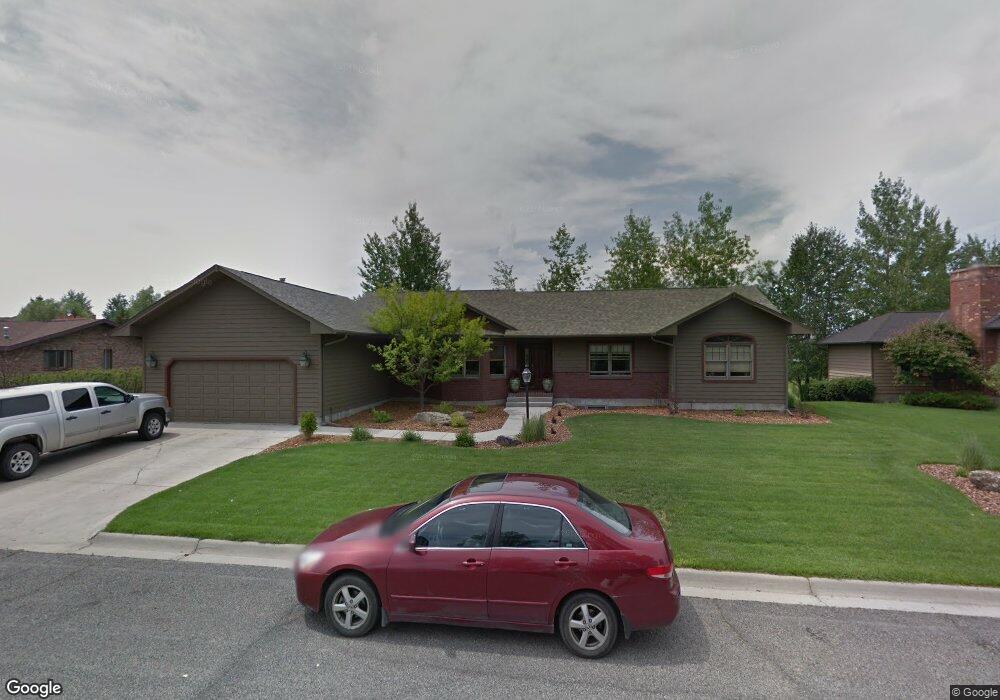
This home is located at 15 Burning Tree Ln, Butte, MT 59701 and is currently estimated at $670,612, approximately $384 per square foot. 15 Burning Tree Ln is a home located in Silver Bow County with nearby schools including Hillcrest Elementary School, East Middle School, and Butte High School.
Ownership History
Date
Name
Owned For
Owner Type
Purchase Details
Closed on
Jul 15, 2025
Sold by
Manson Daniel D and Manson Kristen L
Bought by
Loushin Bryan J and Loushin Jessica L
Current Estimated Value
Home Financials for this Owner
Home Financials are based on the most recent Mortgage that was taken out on this home.
Original Mortgage
$160,000
Outstanding Balance
$158,900
Interest Rate
6.03%
Mortgage Type
New Conventional
Estimated Equity
$511,712
Create a Home Valuation Report for This Property
The Home Valuation Report is an in-depth analysis detailing your home's value as well as a comparison with similar homes in the area
Purchase History
| Date | Buyer | Sale Price | Title Company |
|---|---|---|---|
| Loushin Bryan J | -- | None Listed On Document |
Source: Public Records
Mortgage History
| Date | Status | Borrower | Loan Amount |
|---|---|---|---|
| Open | Loushin Bryan J | $160,000 |
Source: Public Records
Tax History
| Year | Tax Paid | Tax Assessment Tax Assessment Total Assessment is a certain percentage of the fair market value that is determined by local assessors to be the total taxable value of land and additions on the property. | Land | Improvement |
|---|---|---|---|---|
| 2025 | $4,946 | $663,400 | $0 | $0 |
| 2024 | $5,137 | $533,900 | $0 | $0 |
| 2023 | $5,266 | $533,900 | $0 | $0 |
| 2022 | $4,669 | $378,500 | $0 | $0 |
| 2021 | $4,214 | $378,500 | $0 | $0 |
| 2020 | $4,616 | $351,500 | $0 | $0 |
| 2019 | $4,618 | $351,500 | $0 | $0 |
| 2018 | $3,889 | $295,100 | $0 | $0 |
| 2017 | $2,994 | $295,100 | $0 | $0 |
| 2016 | $3,660 | $299,800 | $0 | $0 |
| 2015 | $3,183 | $299,800 | $0 | $0 |
| 2014 | $3,607 | $157,516 | $0 | $0 |
Source: Public Records
Map
Nearby Homes
- 40 N Lake Dr
- 222 Aspen Loop
- 3002 Meadowlark Ln
- 3120 Keokuk St
- 17 Earth Ln
- 2740 Wharton St
- 100 Star Ln
- 3313 Monroe Ave
- 105 Country Club Ln
- 1830 Holmes Ave
- 3320 Paxson Ave
- 2922 E Edwards
- Tbd Harrison Ave
- 2821 Edwards St
- 3440 Burlington St
- 104 Rocky Mountain Ln
- 3001 Busch St
- 1839 Longfellow St
- 13 Bittersweet Dr
- 3101 Paxson Ave
- 21 Burning Tree Ln
- 13 Burning Tree Ln
- 85 Burning Tree Ln
- 87 Burning Tree Ln
- 83 Burning Tree Ln
- 5 Burning Tree Ln
- 25 Burning Tree Ln
- 6 Burning Tree Ln
- 99 Burning Tree Ln
- 20 Burning Tree Ln
- TBD Burning Tree Ln
- 2711 Burke Ln
- 79 Burning Tree Ln
- 84 Burning Tree Ln
- 30 Burning Tree Ln
- 2 Burning Tree Ln
- 35 Burning Tree Ln
- 82 Burning Tree Ln
- 2929 Burke Ln
- 91 Burning Tree Ln
Your Personal Tour Guide
Ask me questions while you tour the home.