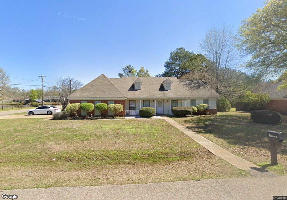
15 Butternut Dr Columbus, MS 39705
Estimated Value: $218,000 - $262,000
3
Beds
2
Baths
1,811
Sq Ft
$135/Sq Ft
Est. Value
About This Home
This home is located at 15 Butternut Dr, Columbus, MS 39705 and is currently estimated at $243,697, approximately $134 per square foot. 15 Butternut Dr is a home located in Lowndes County.
Ownership History
Date
Name
Owned For
Owner Type
Purchase Details
Closed on
Oct 2, 2025
Sold by
Thomas Rebekah Theresa and Green Matthew Bruce
Bought by
Ribac Eric G and Ribac Tomekia
Current Estimated Value
Home Financials for this Owner
Home Financials are based on the most recent Mortgage that was taken out on this home.
Original Mortgage
$268,476
Outstanding Balance
$268,233
Interest Rate
6.5%
Mortgage Type
VA
Estimated Equity
-$24,536
Purchase Details
Closed on
May 11, 2022
Sold by
Duhart Donna M
Bought by
Green Matthew Bruce and Thomas Rebeicah Theresa
Purchase Details
Closed on
Dec 30, 2021
Sold by
Duhart Donna M
Bought by
Duhart Donna M
Create a Home Valuation Report for This Property
The Home Valuation Report is an in-depth analysis detailing your home's value as well as a comparison with similar homes in the area
Purchase History
| Date | Buyer | Sale Price | Title Company |
|---|---|---|---|
| Ribac Eric G | -- | None Listed On Document | |
| Green Matthew Bruce | -- | None Listed On Document | |
| Duhart Donna M | -- | None Listed On Document |
Source: Public Records
Mortgage History
| Date | Status | Borrower | Loan Amount |
|---|---|---|---|
| Open | Ribac Eric G | $268,476 |
Source: Public Records
Tax History
| Year | Tax Paid | Tax Assessment Tax Assessment Total Assessment is a certain percentage of the fair market value that is determined by local assessors to be the total taxable value of land and additions on the property. | Land | Improvement |
|---|---|---|---|---|
| 2025 | $2,014 | $20,582 | $0 | $0 |
| 2024 | $1,997 | $20,582 | $0 | $0 |
| 2023 | $1,786 | $18,482 | $0 | $0 |
| 2022 | $1,787 | $18,482 | $0 | $0 |
| 2021 | $1,721 | $18,482 | $0 | $0 |
| 2020 | $1,627 | $18,482 | $0 | $0 |
| 2019 | $1,652 | $18,311 | $0 | $0 |
| 2018 | $1,652 | $18,215 | $0 | $0 |
| 2017 | $1,580 | $18,215 | $0 | $0 |
| 2016 | $1,580 | $18,215 | $0 | $0 |
| 2015 | $1,631 | $18,812 | $0 | $0 |
| 2014 | $1,631 | $18,812 | $0 | $0 |
Source: Public Records
Map
Nearby Homes
- 226 Green Hollow Cir
- 6904 Highway 45 N
- 145 Brownlee Dr
- 0 Rd Unit 25-1952
- 0 N Frontage Rd Unit 26-145
- 0 N Frontage Rd Unit 25-2336
- 0 N Frontage Rd Unit 26-50
- 0 N Frontage Rd Unit 4135306
- 1372 Mike Parra Rd
- 0 Downs Rd
- 240 Shrinewood Dr
- 134 S Perkins Rd
- 4613 Ridge Rd
- 119 Joel Dr
- 1204 S South Perkins Rd
- 29 Regent Ln
- 0 Mississippi 373
- 45 Greenleaf Ln
- 81 Azalea Trail
- 469 Dogwood Blvd
- 37 Butternut Dr
- 16 N Butternut Dr
- 10 Butternut Dr
- 34 Butternut Dr
- 55 Butternut Dr
- 15 N Butternut Dr
- 52 Butternut Dr
- 36 N Butternut Dr
- 73 Butternut Dr
- 35 N Butternut Dr
- 259 Oakdale Dr
- 15 Chestnut Dr
- 37 Chestnut Dr
- 268 Green Hollow Cir
- 70 Butternut Dr
- 54 N Butternut Dr
- 16 N Chestnut Dr
- 55 Chestnut Dr
- 264 Green Hollow Cir
- 53 N Butternut Dr
Your Personal Tour Guide
Ask me questions while you tour the home.