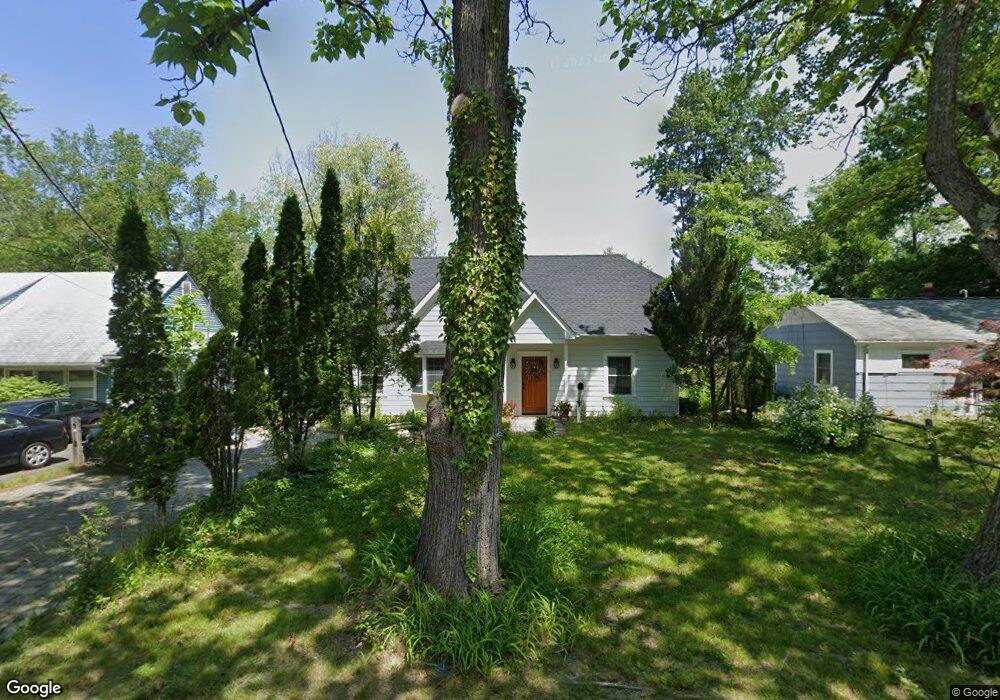
15 Charnwood Rd New Providence, NJ 07974
Estimated Value: $550,328 - $652,000
--
Bed
--
Bath
988
Sq Ft
$607/Sq Ft
Est. Value
About This Home
This home is located at 15 Charnwood Rd, New Providence, NJ 07974 and is currently estimated at $599,332, approximately $606 per square foot. 15 Charnwood Rd is a home located in Union County with nearby schools including New Providence High School and The Academy of Our Lady of Peace.
Ownership History
Date
Name
Owned For
Owner Type
Purchase Details
Closed on
Aug 21, 1995
Sold by
Bristol Oaks Lp
Bought by
Grobert Alan T and Grobert Marisol R
Current Estimated Value
Purchase Details
Closed on
Jun 6, 1994
Sold by
Citicorp Mtg Inc
Bought by
Bristol Oaks Lp
Purchase Details
Closed on
Apr 15, 1994
Sold by
Froehlich Ralph
Bought by
Citicorp Mtg Inc
Create a Home Valuation Report for This Property
The Home Valuation Report is an in-depth analysis detailing your home's value as well as a comparison with similar homes in the area
Home Values in the Area
Average Home Value in this Area
Purchase History
| Date | Buyer | Sale Price | Title Company |
|---|---|---|---|
| Grobert Alan T | $147,000 | Lawyers Title Insurance Corp | |
| Bristol Oaks Lp | $90,776 | -- | |
| Citicorp Mtg Inc | $55,000 | -- |
Source: Public Records
Tax History Compared to Growth
Tax History
| Year | Tax Paid | Tax Assessment Tax Assessment Total Assessment is a certain percentage of the fair market value that is determined by local assessors to be the total taxable value of land and additions on the property. | Land | Improvement |
|---|---|---|---|---|
| 2025 | $9,725 | $188,400 | $104,200 | $84,200 |
| 2024 | $9,433 | $188,400 | $104,200 | $84,200 |
| 2023 | $9,433 | $188,400 | $104,200 | $84,200 |
| 2022 | $7,590 | $153,700 | $104,200 | $49,500 |
| 2021 | $7,534 | $153,700 | $104,200 | $49,500 |
| 2020 | $7,531 | $153,700 | $104,200 | $49,500 |
| 2019 | $7,485 | $153,700 | $104,200 | $49,500 |
| 2018 | $7,447 | $153,700 | $104,200 | $49,500 |
| 2017 | $7,325 | $153,700 | $104,200 | $49,500 |
| 2016 | $7,222 | $153,700 | $104,200 | $49,500 |
| 2015 | $7,122 | $153,700 | $104,200 | $49,500 |
| 2014 | $7,015 | $153,700 | $104,200 | $49,500 |
Source: Public Records
Map
Nearby Homes
- 32 Charnwood Rd
- 29 Walton Ave
- 14 Holmes Oval
- 1200 Springfield Ave Unit 1B
- 100 Commonwealth Ave
- 5 Kincaid Ln
- 36 Terrace Rd
- 16 Terrace Rd
- 197 Elkwood Ave
- 131 van Houton Ave
- 567 River Rd
- 20 High St
- 32 Marion Ave
- 16 Riverbend Ct
- 45 Runnymede Rd
- 34 Grant Ave
- 54 Badgley Dr
- 19 Slope Dr
- 282 South St
- 283 Riveredge Dr