Estimated Value: $908,230 - $950,000
4
Beds
3
Baths
2,454
Sq Ft
$376/Sq Ft
Est. Value
About This Home
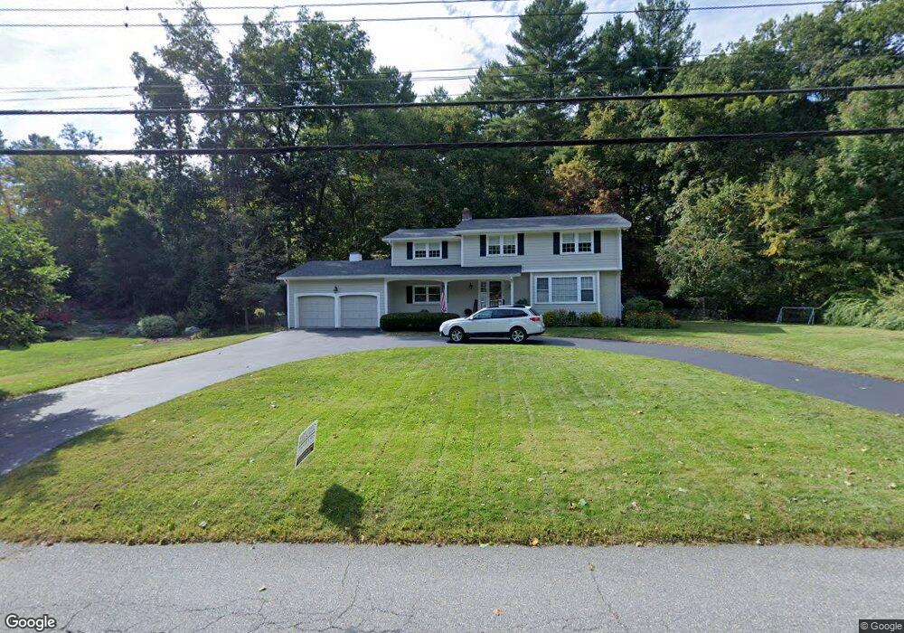
This home is located at 15 Duggan Rd, Acton, MA 01720 and is currently estimated at $922,808, approximately $376 per square foot. 15 Duggan Rd is a home located in Middlesex County with nearby schools including Acton-Boxborough Regional High School.
Ownership History
Date
Name
Owned For
Owner Type
Purchase Details
Closed on
Jun 30, 2003
Sold by
Drakeley Obrie Erin and Brien Stephen O
Bought by
Mcmahon Michelle A and Mcmahon Paul B
Current Estimated Value
Home Financials for this Owner
Home Financials are based on the most recent Mortgage that was taken out on this home.
Original Mortgage
$322,700
Interest Rate
5.53%
Mortgage Type
Purchase Money Mortgage
Purchase Details
Closed on
Feb 26, 1999
Sold by
Rendish Mimi A and Rendish Michael J
Bought by
Obrien Erin D and Obrien Stephen
Home Financials for this Owner
Home Financials are based on the most recent Mortgage that was taken out on this home.
Original Mortgage
$230,000
Interest Rate
6.78%
Mortgage Type
Purchase Money Mortgage
Create a Home Valuation Report for This Property
The Home Valuation Report is an in-depth analysis detailing your home's value as well as a comparison with similar homes in the area
Home Values in the Area
Average Home Value in this Area
Purchase History
| Date | Buyer | Sale Price | Title Company |
|---|---|---|---|
| Mcmahon Michelle A | $494,300 | -- | |
| Obrien Erin D | $290,000 | -- |
Source: Public Records
Mortgage History
| Date | Status | Borrower | Loan Amount |
|---|---|---|---|
| Open | Obrien Erin D | $314,000 | |
| Closed | Obrien Erin D | $318,000 | |
| Closed | Mcmahon Michelle A | $322,700 | |
| Previous Owner | Obrien Erin D | $230,000 |
Source: Public Records
Tax History Compared to Growth
Tax History
| Year | Tax Paid | Tax Assessment Tax Assessment Total Assessment is a certain percentage of the fair market value that is determined by local assessors to be the total taxable value of land and additions on the property. | Land | Improvement |
|---|---|---|---|---|
| 2025 | $13,269 | $773,700 | $314,200 | $459,500 |
| 2024 | $12,409 | $744,400 | $314,200 | $430,200 |
| 2023 | $12,095 | $688,800 | $285,700 | $403,100 |
| 2022 | $11,440 | $588,200 | $248,200 | $340,000 |
| 2021 | $11,163 | $551,800 | $229,800 | $322,000 |
| 2020 | $10,530 | $547,300 | $229,800 | $317,500 |
| 2019 | $10,231 | $528,200 | $229,800 | $298,400 |
| 2018 | $10,052 | $518,700 | $229,800 | $288,900 |
| 2017 | $9,797 | $514,000 | $229,800 | $284,200 |
| 2016 | $9,613 | $499,900 | $229,800 | $270,100 |
| 2015 | $9,068 | $476,000 | $229,800 | $246,200 |
| 2014 | $8,791 | $452,000 | $229,800 | $222,200 |
Source: Public Records
Map
Nearby Homes
- 12 Olde Lantern Rd
- 3 Heather Hill Rd
- 30 Paul Revere Rd
- 90 Willow St Unit 1
- 92 Willow St Unit 3
- 92 Willow St Unit 2
- 89 Windsor Ave
- 4,7,8 Crestwood Ln
- 285 Central St Unit 285
- 68 Macintosh Ln
- 96 Cedarwood Rd
- 134 Russet Ln
- 5 Elm St Unit 1
- 9 Elm St Unit 1
- 220 Red Acre Rd
- 207 Boxboro Rd
- 19 Railroad St Unit C2
- 169 Main St
- 131 Main St
- 129 Main St Unit 129