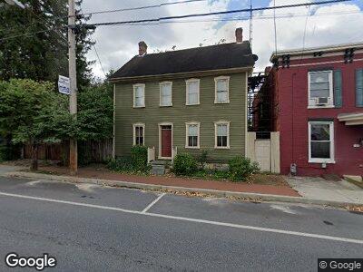
15 E Baltimore St Funkstown, MD 21734
Estimated Value: $190,218 - $290,000
--
Bed
--
Bath
2,010
Sq Ft
$128/Sq Ft
Est. Value
About This Home
This home is located at 15 E Baltimore St, Funkstown, MD 21734 and is currently estimated at $257,305, approximately $128 per square foot. 15 E Baltimore St is a home located in Washington County with nearby schools including Ruth Ann Monroe Primary School, Eastern Elementary School, and E. Russell Hicks Middle School.
Ownership History
Date
Name
Owned For
Owner Type
Purchase Details
Closed on
Apr 19, 2000
Sold by
Kline Donald J and Kline Angela M
Bought by
Kline Donald J
Current Estimated Value
Purchase Details
Closed on
Jun 5, 1984
Sold by
Meacham Thomas Jonathan
Bought by
Kline Donald J and Kline Angela M
Home Financials for this Owner
Home Financials are based on the most recent Mortgage that was taken out on this home.
Original Mortgage
$52,900
Interest Rate
14.29%
Create a Home Valuation Report for This Property
The Home Valuation Report is an in-depth analysis detailing your home's value as well as a comparison with similar homes in the area
Home Values in the Area
Average Home Value in this Area
Purchase History
| Date | Buyer | Sale Price | Title Company |
|---|---|---|---|
| Kline Donald J | -- | -- | |
| Kline Donald J | $61,500 | -- |
Source: Public Records
Mortgage History
| Date | Status | Borrower | Loan Amount |
|---|---|---|---|
| Open | Kline Donald J | $160,000 | |
| Closed | Kline Donald J | $128,000 | |
| Previous Owner | Kline Donald J | $52,900 |
Source: Public Records
Tax History Compared to Growth
Tax History
| Year | Tax Paid | Tax Assessment Tax Assessment Total Assessment is a certain percentage of the fair market value that is determined by local assessors to be the total taxable value of land and additions on the property. | Land | Improvement |
|---|---|---|---|---|
| 2024 | $1,069 | $117,300 | $55,100 | $62,200 |
| 2023 | $997 | $116,067 | $0 | $0 |
| 2022 | $873 | $114,833 | $0 | $0 |
| 2021 | $1,057 | $113,600 | $55,100 | $58,500 |
| 2020 | $18 | $113,600 | $55,100 | $58,500 |
| 2019 | $1,088 | $113,600 | $55,100 | $58,500 |
| 2018 | $1,115 | $119,300 | $62,600 | $56,700 |
| 2017 | $1,099 | $118,400 | $0 | $0 |
| 2016 | -- | $117,500 | $0 | $0 |
| 2015 | $1,157 | $116,600 | $0 | $0 |
| 2014 | $1,157 | $116,600 | $0 | $0 |
Source: Public Records
Map
Nearby Homes
- 77 N High St
- 105 E Maple St
- 100 S High St
- 300 S Antietam St
- 0 Old National Pike Unit MDWA2028976
- 1217 Frederick St
- 6 Charlotte St
- 61 Herman Gaver Place
- 27 Charlotte St
- 701 Beaver Creek Rd
- 705 Beaver Creek Rd
- 655 Knightsbridge Dr
- 349 Winding Oak Dr
- 202 Winding Oak Dr
- 1222 S Pointe Dr
- 0 Kenly Ave
- 1619 Dual Hwy
- 147 Buttercup Dr
- 648 650 E Wilson Blvd
- 1006 302 Brinker Dr
- 15 E Baltimore St
- 13 E Baltimore St
- 13 E Baltimore St
- 11 E Baltimore St
- 7 Baltimore St E
- 43 Baltimore 43-45 St E
- 21 Baltimore St E
- 7 E Baltimore St
- 16 Baltimore St E
- 16 E Baltimore St
- 19 Baltimore St
- 16 E Baltimore St
- 14 E Baltimore St
- 14 E Baltimore St
- 5 E Baltimore St
- 8 E Baltimore St
- 8 Baltimore Street -10 E
- 4 E Baltimore St
- 27 Baltimore St E
- 6 E Baltimore St