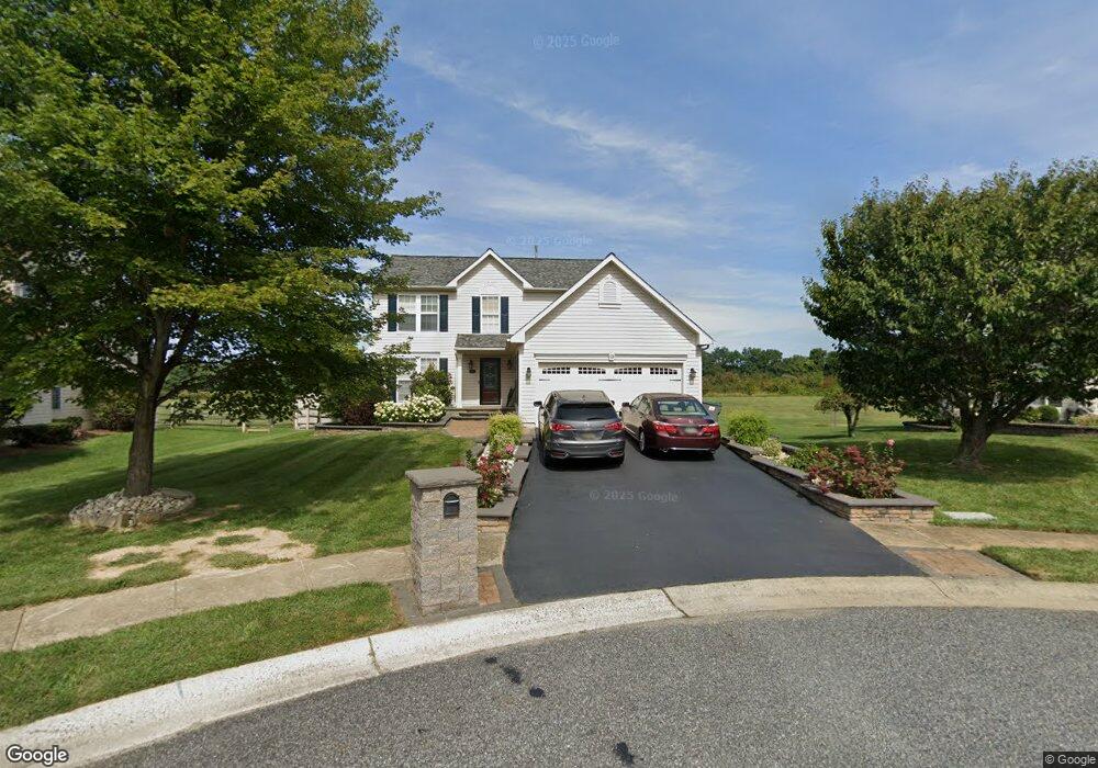
15 E Lexton Rd New Castle, DE 19720
Estimated Value: $422,981 - $477,000
4
Beds
3
Baths
1,944
Sq Ft
$232/Sq Ft
Est. Value
About This Home
This home is located at 15 E Lexton Rd, New Castle, DE 19720 and is currently estimated at $450,495, approximately $231 per square foot. 15 E Lexton Rd is a home located in New Castle County with nearby schools including Southern Elementary School, Gunning Bedford Middle School, and Fairwinds Christian School.
Ownership History
Date
Name
Owned For
Owner Type
Purchase Details
Closed on
May 31, 2007
Sold by
Patrick Karl and Patrick Michelle
Bought by
Ajiroba Mosunmola A
Current Estimated Value
Home Financials for this Owner
Home Financials are based on the most recent Mortgage that was taken out on this home.
Original Mortgage
$264,000
Outstanding Balance
$161,977
Interest Rate
6.24%
Mortgage Type
Purchase Money Mortgage
Estimated Equity
$288,518
Purchase Details
Closed on
May 27, 2005
Sold by
Garrett Deloyd D and Garrett Dorothy L
Bought by
Patrick Karl and Patrick Michelle
Home Financials for this Owner
Home Financials are based on the most recent Mortgage that was taken out on this home.
Original Mortgage
$270,300
Interest Rate
8.5%
Mortgage Type
Fannie Mae Freddie Mac
Create a Home Valuation Report for This Property
The Home Valuation Report is an in-depth analysis detailing your home's value as well as a comparison with similar homes in the area
Home Values in the Area
Average Home Value in this Area
Purchase History
| Date | Buyer | Sale Price | Title Company |
|---|---|---|---|
| Ajiroba Mosunmola A | $330,000 | Transnation Title Ins Co | |
| Patrick Karl | $318,000 | -- |
Source: Public Records
Mortgage History
| Date | Status | Borrower | Loan Amount |
|---|---|---|---|
| Open | Ajiroba Mosunmola A | $264,000 | |
| Previous Owner | Patrick Karl | $270,300 |
Source: Public Records
Tax History
| Year | Tax Paid | Tax Assessment Tax Assessment Total Assessment is a certain percentage of the fair market value that is determined by local assessors to be the total taxable value of land and additions on the property. | Land | Improvement |
|---|---|---|---|---|
| 2024 | $2,597 | $74,800 | $11,000 | $63,800 |
| 2023 | $2,365 | $74,800 | $11,000 | $63,800 |
| 2022 | $2,460 | $74,800 | $11,000 | $63,800 |
| 2021 | $2,457 | $74,800 | $11,000 | $63,800 |
| 2020 | $2,466 | $74,800 | $11,000 | $63,800 |
| 2019 | $2,757 | $74,800 | $11,000 | $63,800 |
| 2018 | $2,425 | $74,800 | $11,000 | $63,800 |
| 2017 | $2,271 | $74,800 | $11,000 | $63,800 |
| 2016 | $2,025 | $74,800 | $11,000 | $63,800 |
| 2015 | $2,028 | $74,800 | $11,000 | $63,800 |
| 2014 | $1,720 | $74,800 | $11,000 | $63,800 |
Source: Public Records
Map
Nearby Homes
- 5 Liborio Ln
- 46 Liborio Ln
- 217 Southerland Dr
- 338 Schafer Blvd
- 203 Shorewind Rd
- 734 Pulaski Hwy Unit 17
- 250 Appleby Rd
- 719 Cardinal Ave
- 120 Channing Dr
- 203 Channing Dr
- 10 Candlewick Ct
- 422 Calburn Ct
- 1049 Old Forge Rd
- 205 Stonebridge Blvd
- 21 Andover Ct
- 513 Stonebridge Blvd
- 21 Charles Dr
- 213 Highland Blvd Unit 44
- 85 Mackenzie Ct
- 105 Layton Dr
- 13 E Lexton Rd
- 17 E Lexton Rd
- 19 E Lexton Rd
- 11 E Lexton Rd
- 16 E Lexton Rd
- 20 E Lexton Rd
- 10 E Lexton Rd
- 18 E Lexton Rd
- 9 E Lexton Rd
- 181 Malcolm Forest Rd
- 183 Malcolm Forest Rd
- 179 Malcolm Forest Rd
- 6 E Lexton Rd
- 185 Malcolm Forest Rd
- 177 Malcolm Forest Rd
- 7 E Lexton Rd
- 187 Malcolm Forest Rd
- 175 Malcolm Forest Rd
- 4 E Lexton Rd
- 10 E Weatherly Rd
Your Personal Tour Guide
Ask me questions while you tour the home.