
15 Ericsson St Worcester, MA 01606
Greendale NeighborhoodEstimated payment $4,597/month
Highlights
- Property is near public transit and schools
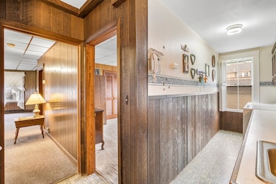
- Bathtub
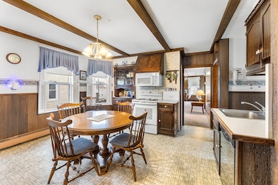
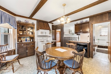
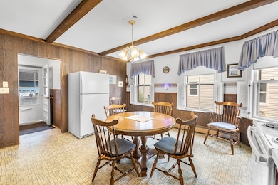
- Combination Dining and Living Room
- Wood Flooring
- Crown Molding
- Baseboard Heating
About This Home
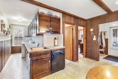
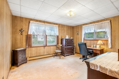
This property offers not only off-street parking but a 3-bay garage with workshop space, a sure premium amenity in Worcester. Each floor has 2 bedrooms with the potential for a 3rd bedroom. 1 full bath and in-unit laundry on each floor. Well maintained 3-family property demonstrates true pride of ownership. Family owned and occupied for nearly 70 years; this property is a commuter's dream. Located in desirable Greendale neighborhood close to major highways, universities, restaurants and shopping! Come see the custom cabinetry and woodwork throughout! Abundant storage in full basement and walk-up attic. House roof less than 10 yrs old, garage roof also newer. First floor is available for owner occupant, enjoy property ownership with rental income to help pay the mortgage. Great investor opportunity in desired area of Worcester.
Property Details
Home Type
- Multi-Family
Est. Annual Taxes
- $9,051
Year Built
- Built in 1920
Parking
- 3 Car Garage
- Driveway
- 6 Open Parking Spaces
- Off-Street Parking
Home Design
- Stone Foundation
Interior Spaces
- 3,780 Sq Ft Home
- Property has 1 Level
- Crown Molding
- Combination Dining and Living Room
- Unfinished Basement
- Basement Fills Entire Space Under The House
Kitchen
- Range
- Dishwasher
Flooring
- Wood
- Carpet
- Vinyl
Bedrooms and Bathrooms
- 6 Bedrooms
- 3 Full Bathrooms
- Bathtub
Utilities
- Window Unit Cooling System
- Heating System Uses Natural Gas
- Baseboard Heating
Additional Features
- 6,693 Sq Ft Lot
- Property is near public transit and schools
Community Details
- 3 Units
- Net Operating Income $45,600
Listing and Financial Details
- Rent includes unit 2(water), unit 3(water)
- Assessor Parcel Number M:12 B:002 L:00030,1773799
Map
Home Values in the Area
Average Home Value in this Area
Tax History
| Year | Tax Paid | Tax Assessment Tax Assessment Total Assessment is a certain percentage of the fair market value that is determined by local assessors to be the total taxable value of land and additions on the property. | Land | Improvement |
|---|---|---|---|---|
| 2025 | $9,051 | $686,200 | $114,600 | $571,600 |
| 2024 | $8,403 | $611,100 | $114,600 | $496,500 |
| 2023 | $8,055 | $561,700 | $99,600 | $462,100 |
| 2022 | $7,051 | $463,600 | $79,700 | $383,900 |
| 2021 | $6,519 | $400,400 | $63,700 | $336,700 |
| 2020 | $4,872 | $286,600 | $63,800 | $222,800 |
| 2019 | $4,878 | $271,000 | $57,300 | $213,700 |
| 2018 | $4,814 | $254,600 | $57,300 | $197,300 |
| 2017 | $4,569 | $237,700 | $57,300 | $180,400 |
| 2016 | $4,349 | $211,000 | $42,200 | $168,800 |
| 2015 | $4,235 | $211,000 | $42,200 | $168,800 |
| 2014 | $4,123 | $211,000 | $42,200 | $168,800 |
Property History
| Date | Event | Price | List to Sale | Price per Sq Ft |
|---|---|---|---|---|
| 11/24/2025 11/24/25 | Pending | -- | -- | -- |
| 09/26/2025 09/26/25 | For Sale | $740,000 | -- | $196 / Sq Ft |
Purchase History
| Date | Type | Sale Price | Title Company |
|---|---|---|---|
| Quit Claim Deed | -- | None Available | |
| Quit Claim Deed | -- | None Available |
Source: MLS Property Information Network (MLS PIN)
MLS Number: 73436427
APN: WORC-000012-000002-000030
Disclaimer: Certain information contained herein is derived from information provided by parties other than Homes.com. All information provided is deemed reliable, but is not guaranteed to be accurate and should be independently verified.
![]() The property listing data and information, or the Images, set forth herein were provided to MLS Property Information Network, Inc. from third party sources, including sellers, lessors and public records, and were compiled by MLS Property Information Network, Inc. The property listing data and information, and the Images, are for the personal, non-commercial use of consumers having a good faith interest in purchasing or leasing listed properties of the type displayed to them and may not be used for any purpose other than to identify prospective properties which such consumers may have a good faith interest in purchasing or leasing. MLS Property Information Network, Inc. and its subscribers disclaim any and all representations and warranties as to the accuracy of the property listing data and information, or as to the accuracy of any of the Images, set forth herein.
The property listing data and information, or the Images, set forth herein were provided to MLS Property Information Network, Inc. from third party sources, including sellers, lessors and public records, and were compiled by MLS Property Information Network, Inc. The property listing data and information, and the Images, are for the personal, non-commercial use of consumers having a good faith interest in purchasing or leasing listed properties of the type displayed to them and may not be used for any purpose other than to identify prospective properties which such consumers may have a good faith interest in purchasing or leasing. MLS Property Information Network, Inc. and its subscribers disclaim any and all representations and warranties as to the accuracy of the property listing data and information, or as to the accuracy of any of the Images, set forth herein.
