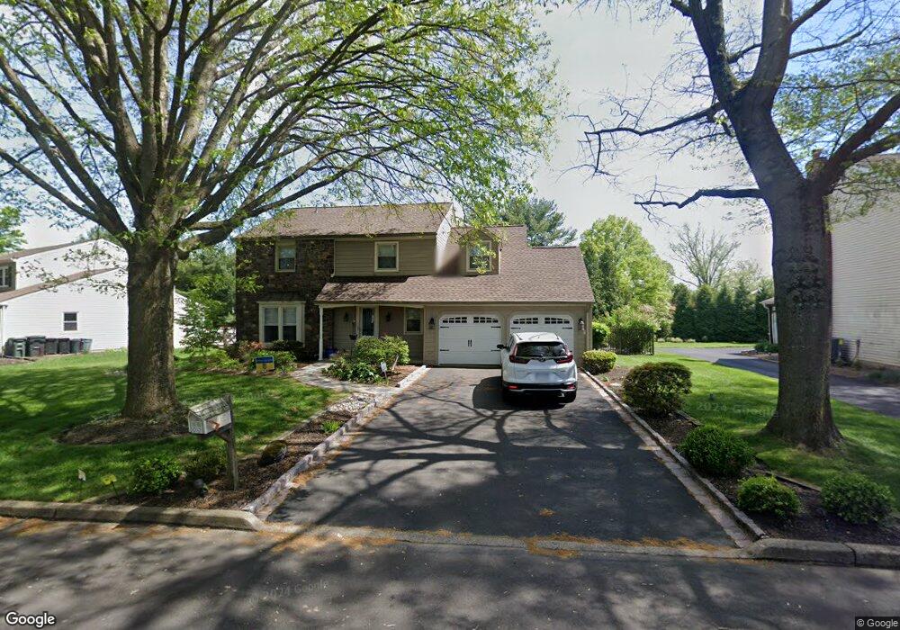
15 Forrest Dr Southampton, PA 18966
Estimated Value: $817,000 - $892,000
4
Beds
3
Baths
3,063
Sq Ft
$280/Sq Ft
Est. Value
About This Home
This home is located at 15 Forrest Dr, Southampton, PA 18966 and is currently estimated at $858,984, approximately $280 per square foot. 15 Forrest Dr is a home located in Bucks County with nearby schools including Hillcrest El School, Holland Middle School, and Council Rock High School - South.
Ownership History
Date
Name
Owned For
Owner Type
Purchase Details
Closed on
Mar 8, 2024
Sold by
Weston Loretta and Ostroff Natalie
Bought by
Weston Loretta and Ostroff Steven
Current Estimated Value
Purchase Details
Closed on
Mar 4, 2024
Sold by
Ostroff Perry
Bought by
Weston Loretta and Ostroff Steven
Purchase Details
Closed on
Jun 18, 1999
Sold by
Klumpp Richard K and Klumpp Margaret A
Bought by
Ostroff Perry and Weston Loretta
Purchase Details
Closed on
Sep 9, 1983
Bought by
Klumpp Richard K and Klumpp Margaret A
Create a Home Valuation Report for This Property
The Home Valuation Report is an in-depth analysis detailing your home's value as well as a comparison with similar homes in the area
Home Values in the Area
Average Home Value in this Area
Purchase History
| Date | Buyer | Sale Price | Title Company |
|---|---|---|---|
| Weston Loretta | -- | None Listed On Document | |
| Weston Loretta | -- | None Listed On Document | |
| Ostroff Perry | $249,000 | -- | |
| Klumpp Richard K | $129,000 | -- |
Source: Public Records
Tax History Compared to Growth
Tax History
| Year | Tax Paid | Tax Assessment Tax Assessment Total Assessment is a certain percentage of the fair market value that is determined by local assessors to be the total taxable value of land and additions on the property. | Land | Improvement |
|---|---|---|---|---|
| 2025 | $10,016 | $52,000 | $7,000 | $45,000 |
| 2024 | $10,016 | $52,000 | $7,000 | $45,000 |
| 2023 | $9,439 | $52,000 | $7,000 | $45,000 |
| 2022 | $9,353 | $52,000 | $7,000 | $45,000 |
| 2021 | $9,057 | $52,000 | $7,000 | $45,000 |
| 2020 | $8,854 | $52,000 | $7,000 | $45,000 |
| 2019 | $8,474 | $52,000 | $7,000 | $45,000 |
| 2018 | $8,324 | $52,000 | $7,000 | $45,000 |
| 2017 | $8,003 | $52,000 | $7,000 | $45,000 |
| 2016 | $8,003 | $52,000 | $7,000 | $45,000 |
| 2015 | -- | $52,000 | $7,000 | $45,000 |
| 2014 | -- | $52,000 | $7,000 | $45,000 |
Source: Public Records
Map
Nearby Homes
- 6 Rolling Hills Dr
- 258 Woodlake Dr
- 41 Grant Dr
- 178 Buckshire Dr
- 27 Rocking Horse Way
- 270 Rocksville Rd
- 29 Langhorne Ave
- 7 Bennett Place
- 147 Watergate Dr
- 21019 Bennett Place Unit 7
- 527 Ashton Cir
- 52 Dalton Way
- 537 Ashton Cir
- 518 Pebble Ridge Ct
- 6 Springwood Place
- 15 Dover Place
- 6 Windy Knoll Dr
- 2604 Beacon Hill Dr Unit 2
- 935 Edgewood Ln
- 415 Fox Hollow Dr