15 Hendrie Ave Riverside, CT 06878
Riverside AreaEstimated Value: $2,919,437 - $4,300,000
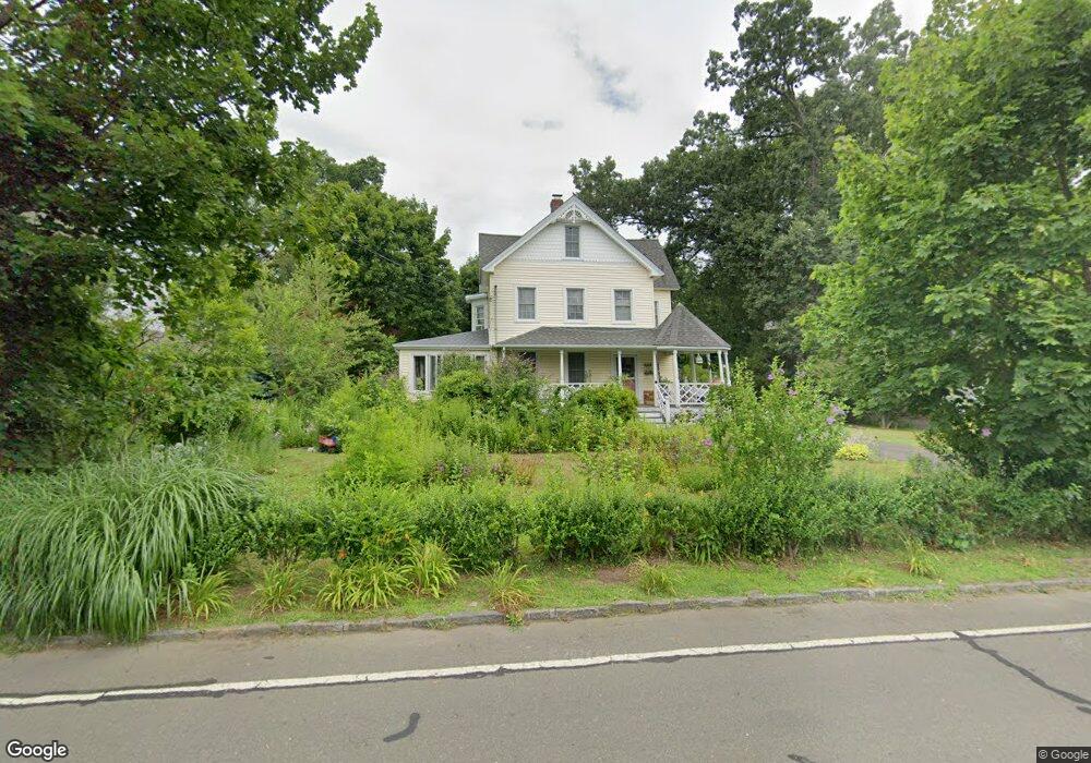
About This Home
This home is located at 15 Hendrie Ave, Riverside, CT 06878 and is currently estimated at $3,400,109, approximately $1,292 per square foot. 15 Hendrie Ave is a home located in Fairfield County with nearby schools including Riverside School, Eastern Middle School, and Greenwich High School.
Ownership History
We collect this data history from publicly available records. To have your information removed, we recommend requesting removal directly through your county’s website.
Purchase Details
Home Values in the Area
Average Home Value in this Area
Purchase History
We collect this data history from publicly available records. To have your information removed, we recommend requesting removal directly through your county’s website.
| Date | Buyer | Sale Price | Title Company |
|---|---|---|---|
| -- | -- |
Mortgage History
We collect this data history from publicly available records. To have your information removed, we recommend requesting removal directly through your county’s website.
| Date | Status | Borrower | Loan Amount |
|---|---|---|---|
| Previous Owner | $300,000 | ||
| Previous Owner | $305,000 | ||
| Previous Owner | $302,000 | ||
| Previous Owner | $317,000 | ||
| Previous Owner | $175,000 |
Tax History
We collect this data history from publicly available records. To have your information removed, we recommend requesting removal directly through your county’s website.
| Year | Tax Paid | Tax Assessment Tax Assessment Total Assessment is a certain percentage of the fair market value that is determined by local assessors to be the total taxable value of land and additions on the property. | Land | Improvement |
|---|---|---|---|---|
| 2025 | $17,605 | $1,424,430 | $1,100,260 | $324,170 |
| 2024 | $17,002 | $1,424,430 | $1,100,260 | $324,170 |
| 2023 | $16,575 | $1,424,430 | $1,100,260 | $324,170 |
| 2022 | $16,424 | $1,424,430 | $1,100,260 | $324,170 |
| 2021 | $14,775 | $1,227,170 | $863,310 | $363,860 |
| 2020 | $14,751 | $1,227,170 | $863,310 | $363,860 |
| 2019 | $14,832 | $1,221,710 | $863,310 | $358,400 |
| 2018 | $14,502 | $1,221,710 | $863,310 | $358,400 |
| 2017 | $14,684 | $1,221,710 | $863,310 | $358,400 |
| 2016 | $14,452 | $1,221,710 | $863,310 | $358,400 |
| 2015 | $13,654 | $1,144,990 | $899,990 | $245,000 |
| 2014 | $13,311 | $1,144,990 | $899,990 | $245,000 |
Map
- 24 Oval Ave
- 14 Bradbury Place
- 93 Summit Rd
- 15 River Rd Unit 205
- 7 Indian Head Rd
- 11 Hearthstone Dr
- 33 Mead Ave
- 7 River Rd Unit Boat Slip C-8
- 7 River Rd Unit Boat Slip A-2
- 7 River Rd Unit Boat Slip E3
- 7 River Rd Unit Boat Slip H3
- 18 Owenoke Way
- 11 Field Rd
- 115 River Rd Unit 3
- 23 Riverside Ln
- 35 Owenoke Way
- 49 Valley Rd Unit C1
- 14 Neil Ln
- 35 Welwyn Rd
- 4 Cos Cob Ave
- 11 Hendrie Ave
- 105 Riverside Ave
- 101 Riverside Ave
- 9 Riverside Ave
- 8 Hendrie Ave
- 99 Riverside Ave
- 19 Hendrie Ave
- 14 Hendrie Ave
- 17 Hendrie Ave
- 109 Riverside Ave
- 6 Hendrie Ave
- 12 Hendrie Ave
- 21 Hendrie Ave
- 12 Lockwood Rd
- 16 Hendrie Ave
- 3 Chapel Ln
- 8 Lockwood Rd
- 16 Lockwood Rd
- 115 Riverside Ave
- 23 Hendrie Ave
Ask me questions while you tour the home.