
Seller's Agent in 2026
Erin Byrd
Jason Mitchell Real Estate Georgia
(470) 967-0120
1 in this area
20 Total Sales
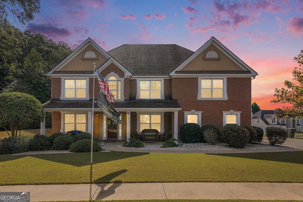
Well-Maintained 5BR/2.5BA Home in Desirable Kings Ridge Subdivision. This home features a spacious floor plan in Kings Ridge, situated on a beautifully landscaped corner lot with a side-entry garage and level driveway. Inside, you'll find 5 bedrooms, 2.5 baths, and numerous recent updates within the last 5 years including interior paint, wood flooring, carpet, and a renovated kitchen. The oversized primary suite includes a sitting area and is located upstairs along with a convenient laundry room. The layout includes a formal living and dining room, connected by a butler's pantry, and a family room with access to the backyard. An office nook sits near the entry, perfect for remote work or study. Additional features include a roof and HVAC system, not even 10 years old and easy access to I-20 and shopping. Move-in ready and a must-see!
Last Agent to Sell the Property
Jason Mitchell Real Estate Georgia License #392609 Listed on: 10/13/2025
| Date | Type | Sale Price | Title Company |
|---|---|---|---|
| Warranty Deed | $370,000 | -- | |
| Warranty Deed | $125,000 | -- | |
| Deed | $249,500 | -- |
| Date | Status | Loan Amount | Loan Type |
|---|---|---|---|
| Previous Owner | $125,000 | VA | |
| Previous Owner | $199,527 | New Conventional |
| Date | Event | Price | List to Sale | Price per Sq Ft |
|---|---|---|---|---|
| 02/18/2026 02/18/26 | Sold | $370,000 | -5.1% | $123 / Sq Ft |
| 01/07/2026 01/07/26 | Pending | -- | -- | -- |
| 12/01/2025 12/01/25 | Price Changed | $390,000 | -4.6% | $130 / Sq Ft |
| 10/29/2025 10/29/25 | Price Changed | $409,000 | -1.4% | $136 / Sq Ft |
| 10/13/2025 10/13/25 | For Sale | $415,000 | -- | $138 / Sq Ft |
| Year | Tax Paid | Tax Assessment Tax Assessment Total Assessment is a certain percentage of the fair market value that is determined by local assessors to be the total taxable value of land and additions on the property. | Land | Improvement |
|---|---|---|---|---|
| 2025 | $670 | $147,120 | $20,000 | $127,120 |
| 2024 | $736 | $143,200 | $20,000 | $123,200 |
| 2023 | $985 | $143,600 | $9,600 | $134,000 |
| 2022 | $169 | $105,320 | $9,600 | $95,720 |
| 2021 | $73 | $90,240 | $9,600 | $80,640 |
| 2020 | $71 | $75,880 | $9,600 | $66,280 |
| 2019 | $71 | $73,880 | $9,600 | $64,280 |
| 2018 | $71 | $64,280 | $9,600 | $54,680 |
| 2017 | $71 | $62,960 | $9,600 | $53,360 |
| 2016 | $71 | $58,160 | $4,800 | $53,360 |
| 2015 | $70 | $54,080 | $4,800 | $49,280 |
| 2014 | $70 | $54,080 | $0 | $0 |
Seller's Agent in 2026
Erin Byrd
Jason Mitchell Real Estate Georgia
(470) 967-0120
1 in this area
20 Total Sales
Buyer's Agent in 2026
Brandy Jones
Better Homes and Gardens Real Estate
(404) 227-9225
1 in this area
6 Total Sales
Source: Georgia MLS
MLS Number: 10623858
APN: 0026H00000001000
Disclaimer: Certain information contained herein is derived from information provided by parties other than Homes.com. All information provided is deemed reliable, but is not guaranteed to be accurate and should be independently verified.
![]() The data relating to real estate for sale on this web site comes in part from the Broker Reciprocity Program of Georgia MLS. Real estate listings held by brokerage firms other than Redfin are marked with the Broker Reciprocity logo and detailed information about them includes the name of the listing brokers. Information deemed reliable but not guaranteed. Copyright 2026 Georgia MLS. All rights reserved.
The data relating to real estate for sale on this web site comes in part from the Broker Reciprocity Program of Georgia MLS. Real estate listings held by brokerage firms other than Redfin are marked with the Broker Reciprocity logo and detailed information about them includes the name of the listing brokers. Information deemed reliable but not guaranteed. Copyright 2026 Georgia MLS. All rights reserved.
Ask me questions while you tour the home.