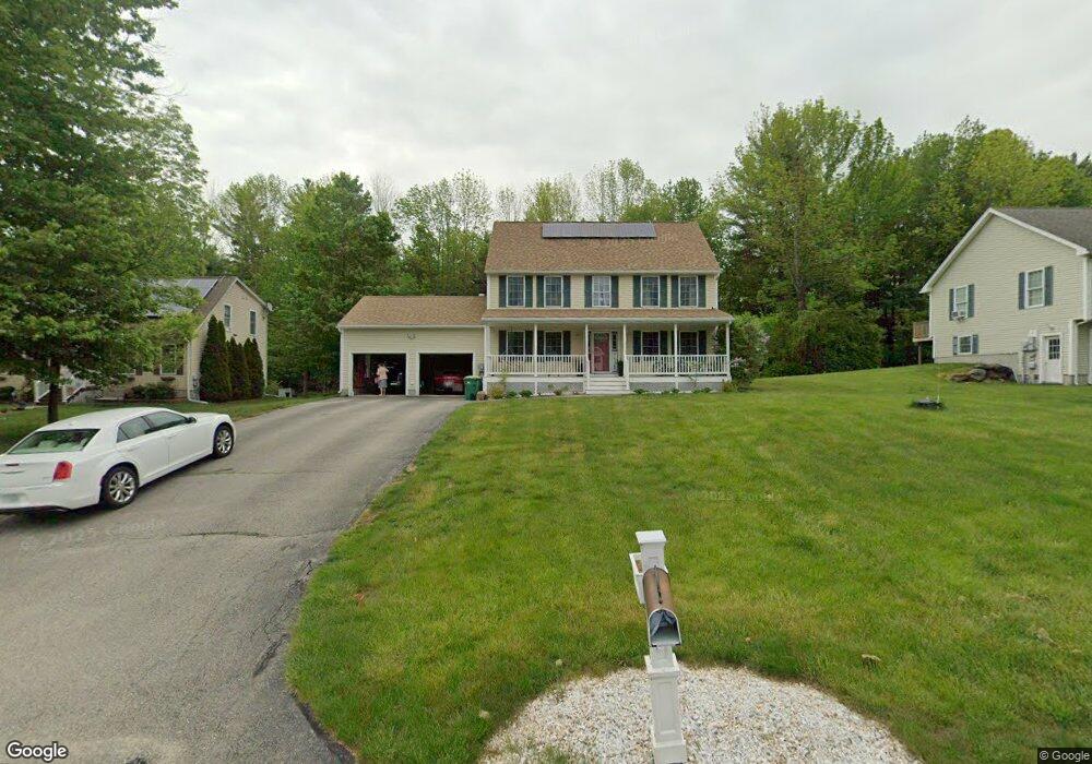
15 Katie Ln Rochester, NH 03868
Estimated Value: $516,000 - $643,000
3
Beds
3
Baths
1,872
Sq Ft
$317/Sq Ft
Est. Value
About This Home
This home is located at 15 Katie Ln, Rochester, NH 03868 and is currently estimated at $593,892, approximately $317 per square foot. 15 Katie Ln is a home located in Strafford County with nearby schools including East Rochester School, Nancy Loud School, and Rochester Middle School.
Ownership History
Date
Name
Owned For
Owner Type
Purchase Details
Closed on
Sep 26, 2008
Sold by
Nk Rt
Bought by
Mccable Donald B
Current Estimated Value
Purchase Details
Closed on
May 12, 2004
Sold by
Salmon Falls Ests Rt
Bought by
Rosie Robert T
Create a Home Valuation Report for This Property
The Home Valuation Report is an in-depth analysis detailing your home's value as well as a comparison with similar homes in the area
Home Values in the Area
Average Home Value in this Area
Purchase History
| Date | Buyer | Sale Price | Title Company |
|---|---|---|---|
| Mccable Donald B | $265,000 | -- | |
| Rosie Robert T | $70,000 | -- |
Source: Public Records
Mortgage History
| Date | Status | Borrower | Loan Amount |
|---|---|---|---|
| Open | Rosie Robert T | $236,000 | |
| Closed | Rosie Robert T | $245,217 | |
| Closed | Rosie Robert T | $243,866 |
Source: Public Records
Tax History Compared to Growth
Tax History
| Year | Tax Paid | Tax Assessment Tax Assessment Total Assessment is a certain percentage of the fair market value that is determined by local assessors to be the total taxable value of land and additions on the property. | Land | Improvement |
|---|---|---|---|---|
| 2024 | $8,436 | $568,100 | $116,700 | $451,400 |
| 2023 | $8,579 | $333,300 | $50,600 | $282,700 |
| 2022 | $8,426 | $333,300 | $50,600 | $282,700 |
| 2021 | $8,216 | $333,300 | $50,600 | $282,700 |
| 2020 | $8,183 | $332,500 | $50,600 | $281,900 |
| 2019 | $8,279 | $332,500 | $50,600 | $281,900 |
| 2018 | $7,633 | $296,700 | $50,600 | $246,100 |
| 2017 | $7,812 | $296,700 | $50,600 | $246,100 |
| 2016 | $8,170 | $289,100 | $50,600 | $238,500 |
| 2015 | $7,522 | $267,200 | $50,600 | $216,600 |
| 2014 | $7,340 | $267,200 | $50,600 | $216,600 |
| 2013 | $6,453 | $244,800 | $59,800 | $185,000 |
| 2012 | $6,286 | $244,800 | $59,800 | $185,000 |
Source: Public Records
Map
Nearby Homes
- 524 Salmon Falls Rd
- 859 Salmon Falls Rd
- 871 Salmon Falls Rd
- 19 Vernon Ave
- 616 Portland St Unit 75
- 17 Maplewood Ave
- 10 Smoke St
- 631 Salmon Falls Rd
- 632 Salmon Falls Rd
- 68 Moose Ln
- 27 Highland St
- 33 Copps Dr
- 21 Copps Dr
- 17 Copps Dr
- 80 Woodland Green
- 3 Freedom Dr Unit 17
- 2 Freedom Dr
- 41 Kinsale Dr
- 39 Ida Cir
- 518 & 532 Portland St
- 19 Katie Ln
- 11 Katie Ln
- 23 Katie Ln
- 7 Katie Ln
- 16 Katie Ln
- 20 Katie Ln
- 12 Katie Ln
- 8 Katie Ln
- 29 Katie Ln
- 518 Salmon Falls Rd
- 514 Salmon Falls Rd
- 508 Salmon Falls Rd
- 709 Portland St
- 703 Portland St
- 713 Portland St
- 699 Portland St
- 717 Portland St
- 532 Salmon Falls Rd
- 500 Salmon Falls Rd
- 517 Salmon Falls Rd