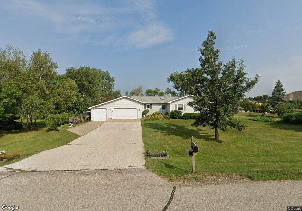
15 Kinson Ct Robins, IA 52328
Estimated Value: $319,000 - $349,578
4
Beds
3
Baths
1,380
Sq Ft
$240/Sq Ft
Est. Value
About This Home
This home is located at 15 Kinson Ct, Robins, IA 52328 and is currently estimated at $331,395, approximately $240 per square foot. 15 Kinson Ct is a home located in Linn County with nearby schools including Nixon Elementary School, Harding Middle School, and John F. Kennedy High School.
Ownership History
Date
Name
Owned For
Owner Type
Purchase Details
Closed on
Jul 30, 2001
Sold by
Morrison Dale W and Morrison Leesa L
Bought by
Kromminga Garry R and Kromminga Willene K
Current Estimated Value
Home Financials for this Owner
Home Financials are based on the most recent Mortgage that was taken out on this home.
Original Mortgage
$65,000
Interest Rate
7.14%
Create a Home Valuation Report for This Property
The Home Valuation Report is an in-depth analysis detailing your home's value as well as a comparison with similar homes in the area
Home Values in the Area
Average Home Value in this Area
Purchase History
| Date | Buyer | Sale Price | Title Company |
|---|---|---|---|
| Kromminga Garry R | $164,000 | -- |
Source: Public Records
Mortgage History
| Date | Status | Borrower | Loan Amount |
|---|---|---|---|
| Closed | Kromminga Garry R | $65,000 |
Source: Public Records
Tax History
| Year | Tax Paid | Tax Assessment Tax Assessment Total Assessment is a certain percentage of the fair market value that is determined by local assessors to be the total taxable value of land and additions on the property. | Land | Improvement |
|---|---|---|---|---|
| 2025 | $3,470 | $343,300 | $36,600 | $306,700 |
| 2024 | $3,470 | $283,300 | $36,600 | $246,700 |
| 2023 | $3,470 | $283,300 | $36,600 | $246,700 |
| 2022 | $3,694 | $240,000 | $36,600 | $203,400 |
| 2021 | $3,644 | $240,000 | $36,600 | $203,400 |
| 2020 | $3,644 | $220,200 | $36,600 | $183,600 |
| 2019 | $3,646 | $224,000 | $54,900 | $169,100 |
Source: Public Records
Map
Nearby Homes
- 9124 Grand Oaks Dr NE
- 8932 Norway Dr NE
- 8926 Norway Dr NE
- 165 Timber Ln
- 625 Freeseway Dr
- 8608 Flatbush Ct NE
- 0 Maple St
- 70.78 Acres M L Quass Rd
- 345 Dutch Dr
- 8201 Council St NE
- 804 Palmyra Dr NE
- 1623 Petrus Dr NE
- 929 Messina Dr NE
- 3230 N Center Point Rd Unit Lot 3
- 1319 Ashford Ct NE
- 620 Hampton St
- 570 Hampton St
- 540 Hampton St
- 560 Hampton St
- 590 Hampton St
- 25 Kinson Ct
- 10 Charlotte Ct
- 10 Kinson Ct
- 30 Charlotte Ct
- 35 Kinson Ct
- 945 Robins Square Dr
- 20 Kinson Ct
- 30 Kinson Ct
- 25 Charlotte Ct
- 900 E Main St
- 950 E Main St
- 975 E Main St
- 40 Kinson Ct
- 45 Kinson Ct
- 15 Charlotte Ct
- 0 Robins Square Dr Unit 1802073
- 0 Robins Square Dr Unit 1700672
- 0 Robins Square Dr Unit 1902838
- 0 Robins Square Dr Unit 1807636
- 9106 Grand Oaks Dr NE
Your Personal Tour Guide
Ask me questions while you tour the home.