Estimated Value: $515,000 - $614,000
3
Beds
2
Baths
1,664
Sq Ft
$341/Sq Ft
Est. Value
About This Home
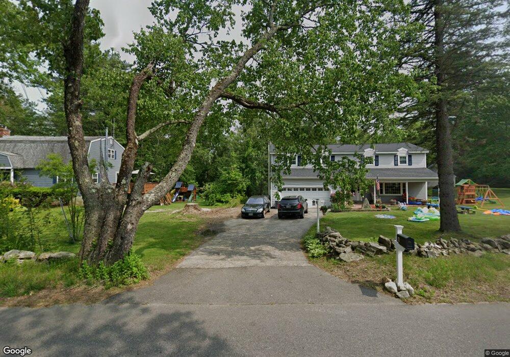
This home is located at 15 Lawrence Rd, Derry, NH 03038 and is currently estimated at $567,163, approximately $340 per square foot. 15 Lawrence Rd is a home located in Rockingham County with nearby schools including Derry Village School, West Running Brook Middle School, and Pinkerton Academy.
Ownership History
Date
Name
Owned For
Owner Type
Purchase Details
Closed on
May 16, 2025
Sold by
Bourque Christopher A and Bourque Lauren M
Bought by
Bourque Ft and Bourque
Current Estimated Value
Purchase Details
Closed on
Dec 1, 2011
Sold by
Ethier Joan E and Ethier James S
Bought by
Bourque Christopher A and Evans Lauren M
Home Financials for this Owner
Home Financials are based on the most recent Mortgage that was taken out on this home.
Original Mortgage
$146,197
Interest Rate
4.1%
Mortgage Type
Purchase Money Mortgage
Purchase Details
Closed on
Feb 20, 1998
Sold by
Rose Irene P
Bought by
Deleo Joan E
Home Financials for this Owner
Home Financials are based on the most recent Mortgage that was taken out on this home.
Original Mortgage
$88,000
Interest Rate
6.9%
Create a Home Valuation Report for This Property
The Home Valuation Report is an in-depth analysis detailing your home's value as well as a comparison with similar homes in the area
Home Values in the Area
Average Home Value in this Area
Purchase History
| Date | Buyer | Sale Price | Title Company |
|---|---|---|---|
| Bourque Ft | -- | None Available | |
| Bourque Ft | -- | None Available | |
| Bourque Christopher A | $150,000 | -- | |
| Bourque Christopher A | $150,000 | -- | |
| Deleo Joan E | $110,000 | -- | |
| Deleo Joan E | $110,000 | -- |
Source: Public Records
Mortgage History
| Date | Status | Borrower | Loan Amount |
|---|---|---|---|
| Previous Owner | Deleo Joan E | $146,197 | |
| Previous Owner | Deleo Joan E | $88,000 |
Source: Public Records
Tax History Compared to Growth
Tax History
| Year | Tax Paid | Tax Assessment Tax Assessment Total Assessment is a certain percentage of the fair market value that is determined by local assessors to be the total taxable value of land and additions on the property. | Land | Improvement |
|---|---|---|---|---|
| 2024 | $8,584 | $459,300 | $205,100 | $254,200 |
| 2023 | $7,827 | $378,500 | $174,300 | $204,200 |
| 2022 | $7,172 | $376,700 | $174,300 | $202,400 |
| 2021 | $6,903 | $278,800 | $134,200 | $144,600 |
| 2020 | $6,786 | $278,800 | $134,200 | $144,600 |
| 2019 | $6,640 | $254,200 | $104,600 | $149,600 |
| 2018 | $6,617 | $254,200 | $104,600 | $149,600 |
| 2017 | $6,698 | $232,100 | $99,600 | $132,500 |
| 2016 | $6,327 | $233,800 | $99,600 | $134,200 |
| 2015 | $6,387 | $218,500 | $99,600 | $118,900 |
| 2014 | $6,428 | $218,500 | $99,600 | $118,900 |
| 2013 | $6,389 | $202,900 | $91,600 | $111,300 |
Source: Public Records
Map
Nearby Homes
- 43 Lampton Dr
- 139 Rockingham Rd Unit 21
- 144 Rockingham Rd
- 13 Kilrea Rd Unit L
- 8 Blueberry Rd Unit U: R
- 242 Rockingham Rd
- 2 Brown Rd
- 30 Kendall Pond Rd Unit 77
- 30 Kendall Pond Rd Unit 87
- 7 Dexter St
- 46 Goodhue Rd
- 26 Partridge Rd
- 6 Michael Ave
- 23 Oak St
- 42 Kendall Pond Rd
- 8 Birch St
- 37 Highland Ave Unit 1
- 84 E Broadway
- 7 Chester Rd Unit 212
- 29 Central St