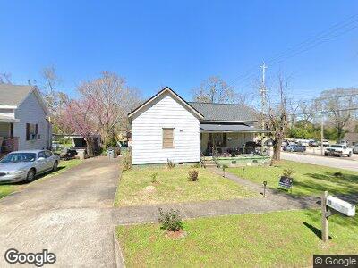
15 Louise St Lagrange, GA 30241
Estimated Value: $92,581 - $192,000
3
Beds
1
Bath
1,500
Sq Ft
$94/Sq Ft
Est. Value
About This Home
This home is located at 15 Louise St, Lagrange, GA 30241 and is currently estimated at $141,145, approximately $94 per square foot. 15 Louise St is a home located in Troup County with nearby schools including Hollis Hand Elementary School, Franklin Forest Elementary School, and Ethel W. Kight Elementary School.
Ownership History
Date
Name
Owned For
Owner Type
Purchase Details
Closed on
Mar 6, 1996
Sold by
Thelma Shelnutt
Bought by
Shelnutt Steven J
Current Estimated Value
Purchase Details
Closed on
Mar 1, 1996
Sold by
Patricia Phillips Brister
Bought by
Thelma Shelnutt
Purchase Details
Closed on
Jan 4, 1993
Sold by
Thelma Louise Phillips
Bought by
Patricia Phillips Brister
Purchase Details
Closed on
Jan 19, 1990
Sold by
Henry Lewis Cole and Henry Betty B
Bought by
Thelma Louise Phillips
Purchase Details
Closed on
Jan 1, 1966
Sold by
Russell W Simpson
Bought by
Henry Lewis Cole and Henry Betty B
Create a Home Valuation Report for This Property
The Home Valuation Report is an in-depth analysis detailing your home's value as well as a comparison with similar homes in the area
Home Values in the Area
Average Home Value in this Area
Purchase History
| Date | Buyer | Sale Price | Title Company |
|---|---|---|---|
| Shelnutt Steven J | $29,500 | -- | |
| Thelma Shelnutt | -- | -- | |
| Patricia Phillips Brister | -- | -- | |
| Thelma Louise Phillips | -- | -- | |
| Henry Lewis Cole | -- | -- |
Source: Public Records
Tax History Compared to Growth
Tax History
| Year | Tax Paid | Tax Assessment Tax Assessment Total Assessment is a certain percentage of the fair market value that is determined by local assessors to be the total taxable value of land and additions on the property. | Land | Improvement |
|---|---|---|---|---|
| 2024 | $422 | $17,476 | $1,840 | $15,636 |
| 2023 | $2 | $1,942 | $0 | $1,942 |
| 2022 | $336 | $14,036 | $1,840 | $12,196 |
| 2021 | $287 | $11,504 | $1,840 | $9,664 |
| 2020 | $287 | $11,504 | $1,840 | $9,664 |
| 2019 | $263 | $10,704 | $1,864 | $8,840 |
| 2018 | $263 | $10,704 | $1,864 | $8,840 |
| 2017 | $263 | $10,704 | $1,864 | $8,840 |
| 2016 | $253 | $10,380 | $1,864 | $8,516 |
| 2015 | $271 | $10,940 | $1,864 | $9,076 |
| 2014 | $257 | $10,463 | $1,864 | $8,599 |
| 2013 | -- | $11,130 | $1,864 | $9,266 |
Source: Public Records
Map
Nearby Homes
- 4 Louise St
- 13 Fulton St
- 21 Barnard Ave
- 5 Curran Ave
- 914 Greenville St
- 1206 Pool Mill St
- 902 Georgia Ave
- 106 Shenandoah Ln Unit E26
- 45 N Cary St
- 124 Shenandoah Ln
- 114 Shenandoah Ln Unit E30
- 122 Shenandoah Ln
- 122 Shenandoah Ln Unit 64
- 713 Windstream Dr Unit B-58
- 211 Rutland Cir
- 205 Freshwater Ct
- 203 Freshwater Ct Unit E32
- 205 Freshwater Ct Unit E33
- 1010 Motley St
- 722 Windstream Dr Unit A-12