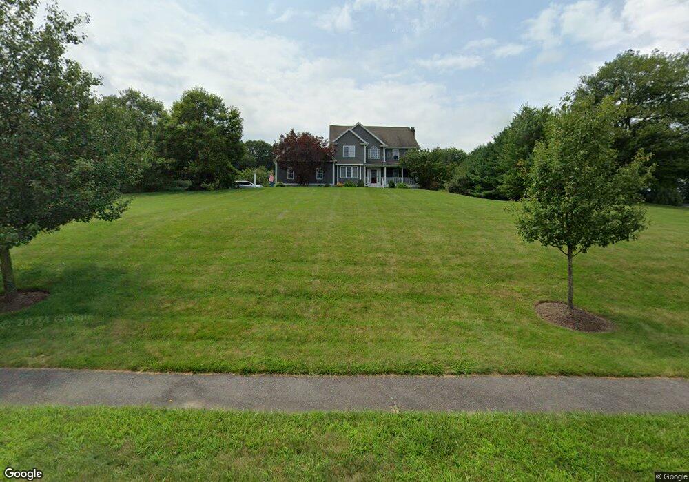
15 Macdougald Dr Wrentham, MA 02093
West Wrentham NeighborhoodEstimated Value: $1,143,000 - $1,426,000
4
Beds
5
Baths
3,706
Sq Ft
$344/Sq Ft
Est. Value
About This Home
This home is located at 15 Macdougald Dr, Wrentham, MA 02093 and is currently estimated at $1,274,837, approximately $343 per square foot. 15 Macdougald Dr is a home located in Norfolk County with nearby schools including Delaney Elementary School, Charles E Roderick, and Benjamin Franklin Classical Charter Public School.
Ownership History
Date
Name
Owned For
Owner Type
Purchase Details
Closed on
Feb 13, 1998
Sold by
Bailey & Zahner Bldrs
Bought by
Balog Robert J and Balog Deborah S
Current Estimated Value
Home Financials for this Owner
Home Financials are based on the most recent Mortgage that was taken out on this home.
Original Mortgage
$316,000
Outstanding Balance
$55,692
Interest Rate
6.95%
Mortgage Type
Purchase Money Mortgage
Estimated Equity
$1,219,145
Create a Home Valuation Report for This Property
The Home Valuation Report is an in-depth analysis detailing your home's value as well as a comparison with similar homes in the area
Home Values in the Area
Average Home Value in this Area
Purchase History
| Date | Buyer | Sale Price | Title Company |
|---|---|---|---|
| Balog Robert J | $399,531 | -- |
Source: Public Records
Mortgage History
| Date | Status | Borrower | Loan Amount |
|---|---|---|---|
| Open | Balog Robert J | $316,000 |
Source: Public Records
Tax History Compared to Growth
Tax History
| Year | Tax Paid | Tax Assessment Tax Assessment Total Assessment is a certain percentage of the fair market value that is determined by local assessors to be the total taxable value of land and additions on the property. | Land | Improvement |
|---|---|---|---|---|
| 2025 | $12,260 | $1,057,800 | $331,200 | $726,600 |
| 2024 | $11,604 | $967,000 | $331,200 | $635,800 |
| 2023 | $11,883 | $941,600 | $301,200 | $640,400 |
| 2022 | $11,235 | $821,900 | $281,300 | $540,600 |
| 2021 | $10,454 | $743,000 | $245,500 | $497,500 |
| 2020 | $10,898 | $764,800 | $218,500 | $546,300 |
| 2019 | $10,450 | $740,100 | $218,500 | $521,600 |
| 2018 | $9,824 | $689,900 | $196,400 | $493,500 |
| 2017 | $9,586 | $672,700 | $192,600 | $480,100 |
| 2016 | $9,393 | $657,800 | $187,000 | $470,800 |
| 2015 | $9,598 | $640,700 | $179,800 | $460,900 |
| 2014 | $9,647 | $630,100 | $172,900 | $457,200 |
Source: Public Records
Map
Nearby Homes
- 60 Grant Ave
- 2095 West St
- 50 Wamsutta Way
- 50 Heather Ln
- 180 Pine Swamp Rd
- 56 Pine Swamp Rd
- 236 Williams St
- 25 Nature View Dr
- 20 Nature View Dr
- 39 Sumner Brown Rd
- 9 Pebble Cir Unit 9
- 219 Dawn Blvd
- 245 W Wrentham Rd
- 65 Palmetto Dr Unit 65
- 300 Tower Hill Rd
- 21 Palmetto Dr Unit 21
- 24 Palmetto Dr Unit 24
- 4022 Diamond Hill Rd
- 2 Duhamel Way
- 10 Stoneham Dr
- 20 Macdougald Dr
- 25 Macdougald Dr
- 5 Macdougald Dr
- 10 Macdougald Dr
- 30 Macdougald Dr
- 85 Summer St
- 95 Summer St
- 75 Summer St
- 115 Summer St
- 40 Macdougald Dr
- 105 Summer St
- 35 Macdougald Dr
- 8 Macdougald Dr
- 65 Summer St
- 170 Autumn Rd
- 1 Macdougald Dr
- 180 Autumn Rd
- 55 Summer St
- 18 Grant Ave
- 45 Macdougald Dr