M
Seller's Agent in 2025
Maureen Pelletier
Berkshire Hathaway Home Services
(860) 575-6971
3 in this area
9 Total Sales
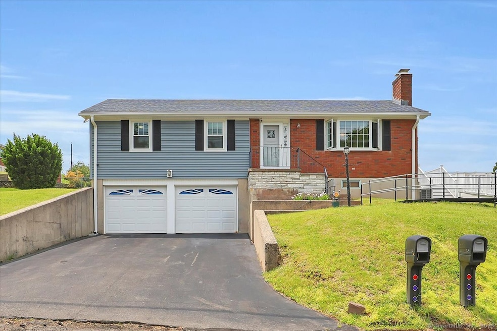
Immaculate home on beautiful piece of land. Stunning brazilian cherry hardwood floors that catch your eye the moment you walk through the door. Living room with fireplace. Three bedrooms Kitchen with french doors opening to a large wrap around deck. ram access to deck .Many new upgrades. new roof new windows ,new siding 2023. New furnace, Upgrade to 200 amp service 2021.new appliances 2023, new bilco door 2021. Alarm & camera system. two car garage. This is a home that you can move right into. Convenient location and lovely setting on 15 Margarite Road
Last Agent to Sell the Property
Berkshire Hathaway NE Prop. License #REB.0790311 Listed on: 06/07/2025

| Date | Type | Sale Price | Title Company |
|---|---|---|---|
| Executors Deed | $340,000 | -- | |
| Warranty Deed | $113,900 | -- | |
| Warranty Deed | $113,900 | -- |
| Date | Status | Loan Amount | Loan Type |
|---|---|---|---|
| Previous Owner | $160,000 | Stand Alone Second | |
| Previous Owner | $192,000 | No Value Available | |
| Previous Owner | $98,000 | No Value Available | |
| Previous Owner | $105,000 | Purchase Money Mortgage |
| Date | Event | Price | List to Sale | Price per Sq Ft |
|---|---|---|---|---|
| 07/30/2025 07/30/25 | Sold | $340,000 | +0.6% | $284 / Sq Ft |
| 07/16/2025 07/16/25 | Pending | -- | -- | -- |
| 07/04/2025 07/04/25 | Price Changed | $338,000 | -5.8% | $283 / Sq Ft |
| 06/07/2025 06/07/25 | For Sale | $359,000 | -- | $300 / Sq Ft |
| Year | Tax Paid | Tax Assessment Tax Assessment Total Assessment is a certain percentage of the fair market value that is determined by local assessors to be the total taxable value of land and additions on the property. | Land | Improvement |
|---|---|---|---|---|
| 2025 | $6,257 | $169,050 | $66,360 | $102,690 |
| 2024 | $5,986 | $169,050 | $66,360 | $102,690 |
| 2023 | $5,682 | $169,050 | $66,360 | $102,690 |
| 2022 | $5,010 | $121,440 | $44,240 | $77,200 |
| 2021 | $4,988 | $121,440 | $44,240 | $77,200 |
| 2020 | $4,979 | $121,440 | $44,240 | $77,200 |
| 2019 | $484 | $121,440 | $44,240 | $77,200 |
| 2018 | $4,703 | $118,210 | $44,240 | $73,970 |
| 2017 | $4,694 | $121,350 | $51,840 | $69,510 |
| 2016 | $4,600 | $121,350 | $51,840 | $69,510 |
| 2015 | $4,498 | $121,350 | $51,840 | $69,510 |
| 2014 | $4,494 | $121,350 | $51,840 | $69,510 |
M
Seller's Agent in 2025
Maureen Pelletier
Berkshire Hathaway Home Services
(860) 575-6971
3 in this area
9 Total Sales
Buyer's Agent in 2025
Mary Jean Agostini
RE/MAX
(860) 995-9665
5 in this area
317 Total Sales
Source: SmartMLS
MLS Number: 24101434
APN: MTWN-000038-000000-000143
Disclaimer: Certain information contained herein is derived from information provided by parties other than Homes.com. All information provided is deemed reliable, but is not guaranteed to be accurate and should be independently verified.
![]() IDX information is provided exclusively for personal, non-commercial use, and may not be used for any purpose other than to identify prospective properties consumers may be interested in purchasing. Information is deemed reliable but not guaranteed.
IDX information is provided exclusively for personal, non-commercial use, and may not be used for any purpose other than to identify prospective properties consumers may be interested in purchasing. Information is deemed reliable but not guaranteed.
Ask me questions while you tour the home.