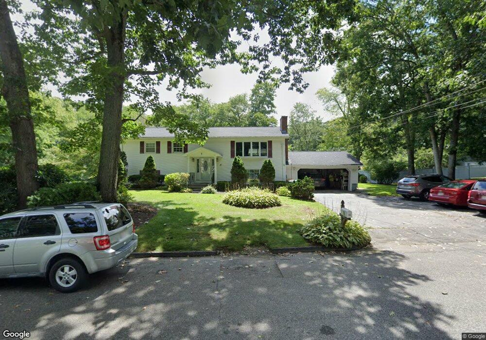
15 Mcgovern Ln Webster, MA 01570
Estimated Value: $565,902
3
Beds
2
Baths
1,378
Sq Ft
$411/Sq Ft
Est. Value
About This Home
This home is located at 15 Mcgovern Ln, Webster, MA 01570 and is currently estimated at $565,902, approximately $410 per square foot. 15 Mcgovern Ln is a home located in Worcester County with nearby schools including Park Avenue Elementary School, Webster Middle School, and Bartlett High School.
Ownership History
Date
Name
Owned For
Owner Type
Purchase Details
Closed on
Jul 28, 2006
Sold by
Harding Christopher W and Harding Marie A
Bought by
Life Skills Inc and Southern Worcester Reh
Current Estimated Value
Home Financials for this Owner
Home Financials are based on the most recent Mortgage that was taken out on this home.
Original Mortgage
$200,000
Outstanding Balance
$117,611
Interest Rate
6.67%
Mortgage Type
Purchase Money Mortgage
Estimated Equity
$448,291
Purchase Details
Closed on
Jun 23, 1999
Sold by
Sidebottom Edmund S and Sidebottom Doris E
Bought by
Barszcz Stanley A and Barszcz Helen R
Home Financials for this Owner
Home Financials are based on the most recent Mortgage that was taken out on this home.
Original Mortgage
$72,000
Interest Rate
7.09%
Mortgage Type
Purchase Money Mortgage
Create a Home Valuation Report for This Property
The Home Valuation Report is an in-depth analysis detailing your home's value as well as a comparison with similar homes in the area
Home Values in the Area
Average Home Value in this Area
Purchase History
| Date | Buyer | Sale Price | Title Company |
|---|---|---|---|
| Life Skills Inc | $310,000 | -- | |
| Barszcz Stanley A | $197,900 | -- |
Source: Public Records
Mortgage History
| Date | Status | Borrower | Loan Amount |
|---|---|---|---|
| Open | Life Skills Inc | $200,000 | |
| Previous Owner | Barszcz Stanley A | $255,000 | |
| Previous Owner | Barszcz Stanley A | $229,500 | |
| Previous Owner | Barszcz Stanley A | $72,000 |
Source: Public Records
Tax History
| Year | Tax Paid | Tax Assessment Tax Assessment Total Assessment is a certain percentage of the fair market value that is determined by local assessors to be the total taxable value of land and additions on the property. | Land | Improvement |
|---|---|---|---|---|
| 2025 | -- | $433,900 | $68,100 | $365,800 |
| 2024 | -- | $422,000 | $65,500 | $356,500 |
| 2023 | $0 | $380,100 | $62,400 | $317,700 |
| 2022 | $0 | $342,700 | $60,600 | $282,100 |
| 2021 | $0 | $316,100 | $60,600 | $255,500 |
| 2020 | $0 | $307,800 | $60,600 | $247,200 |
| 2019 | $0 | $282,000 | $60,600 | $221,400 |
| 2018 | $0 | $269,000 | $60,600 | $208,400 |
| 2017 | $0 | $252,600 | $59,300 | $193,300 |
| 2016 | -- | $241,800 | $59,300 | $182,500 |
| 2015 | -- | $230,000 | $66,500 | $163,500 |
Source: Public Records
Map
Nearby Homes
- 1350 Thompson Rd
- 45 Point Pleasant Rd
- 53-55 Point Pleasant Rd
- 0 Thompson Rd
- 13 S Point Rd
- 38 Colonial Rd
- 16 Black Point Rd
- 7 Nipmuck Dr
- 36 Lake Pkwy
- 125 Birch Island Rd
- 12 Cedar Dr
- 10 Indian Point Rd
- 2 Mary Rd
- 00 Juniper Ln
- 51 &52 lot Oscar Rd
- 0 Porter Plain Rd
- 23 Stefaniak Ave Unit 1
- 24 Cooper Rd
- 192 Stawicki Rd
- 5 Summit St
Your Personal Tour Guide
Ask me questions while you tour the home.