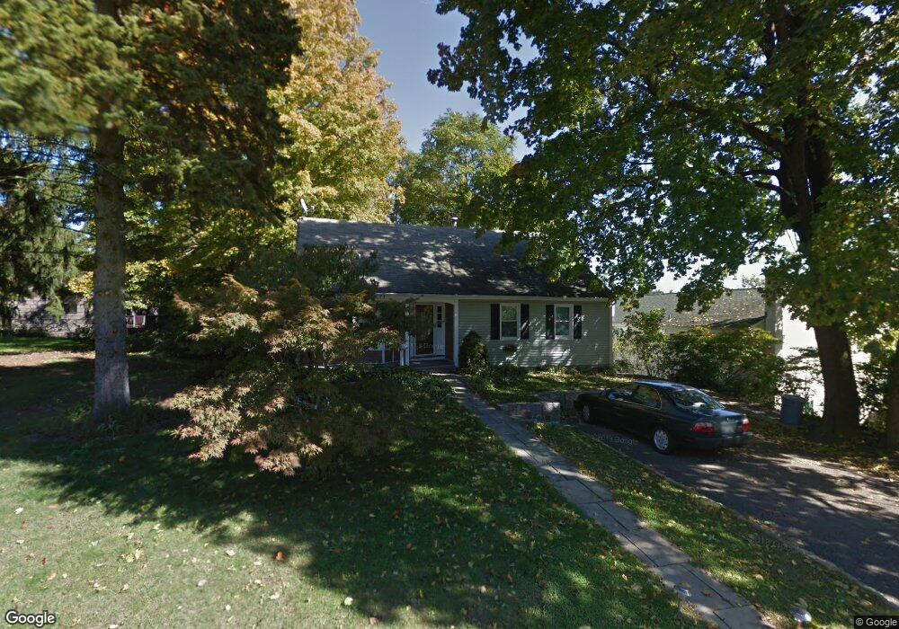
15 Michael St Danbury, CT 06810
Estimated Value: $449,000 - $529,000
4
Beds
2
Baths
1,845
Sq Ft
$272/Sq Ft
Est. Value
About This Home
This home is located at 15 Michael St, Danbury, CT 06810 and is currently estimated at $502,718, approximately $272 per square foot. 15 Michael St is a home located in Fairfield County with nearby schools including South Street School, Rogers Park Middle School, and Danbury High School.
Ownership History
Date
Name
Owned For
Owner Type
Purchase Details
Closed on
Dec 7, 2009
Sold by
Santos Carlos Bernardo and Santos Maria Fatima
Bought by
Osman Shananu Seidu and Swallah Nihad
Current Estimated Value
Home Financials for this Owner
Home Financials are based on the most recent Mortgage that was taken out on this home.
Original Mortgage
$245,000
Interest Rate
5.01%
Purchase Details
Closed on
Jan 11, 1990
Sold by
Trattner Jeffrey
Bought by
Pereira Maria
Home Financials for this Owner
Home Financials are based on the most recent Mortgage that was taken out on this home.
Original Mortgage
$119,000
Interest Rate
9.61%
Create a Home Valuation Report for This Property
The Home Valuation Report is an in-depth analysis detailing your home's value as well as a comparison with similar homes in the area
Home Values in the Area
Average Home Value in this Area
Purchase History
| Date | Buyer | Sale Price | Title Company |
|---|---|---|---|
| Osman Shananu Seidu | $310,000 | -- | |
| Pereira Maria | $169,000 | -- |
Source: Public Records
Mortgage History
| Date | Status | Borrower | Loan Amount |
|---|---|---|---|
| Open | Pereira Maria | $228,000 | |
| Closed | Pereira Maria | $245,000 | |
| Previous Owner | Pereira Maria | $119,000 | |
| Previous Owner | Pereira Maria | $40,000 |
Source: Public Records
Tax History Compared to Growth
Tax History
| Year | Tax Paid | Tax Assessment Tax Assessment Total Assessment is a certain percentage of the fair market value that is determined by local assessors to be the total taxable value of land and additions on the property. | Land | Improvement |
|---|---|---|---|---|
| 2025 | $6,103 | $244,230 | $60,480 | $183,750 |
| 2024 | $5,969 | $244,230 | $60,480 | $183,750 |
| 2023 | $5,698 | $244,230 | $60,480 | $183,750 |
| 2022 | $5,015 | $177,700 | $64,700 | $113,000 |
| 2021 | $4,905 | $177,700 | $64,700 | $113,000 |
| 2020 | $4,905 | $177,700 | $64,700 | $113,000 |
| 2019 | $4,905 | $177,700 | $64,700 | $113,000 |
| 2018 | $4,905 | $177,700 | $64,700 | $113,000 |
| 2017 | $4,840 | $167,200 | $61,600 | $105,600 |
| 2016 | $4,795 | $167,200 | $61,600 | $105,600 |
| 2015 | $4,725 | $167,200 | $61,600 | $105,600 |
| 2014 | $4,615 | $167,200 | $61,600 | $105,600 |
Source: Public Records
Map
Nearby Homes
- 17 Casper St
- 51 Wildman St Unit A312
- 47 Liberty Ave
- 127 Triangle St
- 163 South St Unit 72
- 22 Main St Unit 2-13
- 22 Main St Unit 2-14
- 63 Grand St
- 35 Briarwood Dr
- 8 Briarwood Dr
- 67 Garfield Ave
- 136 Deer Hill Ave Unit 11
- 24 Homestead Ave
- 81 Coalpit Hill Rd Unit B
- 63A Main St
- 28 Homestead Ave Unit 2
- 29 William St
- 29 William St
- 25 E Cross Trail Unit 25
- 22 Brentwood Cir Unit 22